Colonie dates to 1895, and 45 of its places are on the National Register
More historic than 53% of U.S. towns · #653 of 758 in New York. What drives it
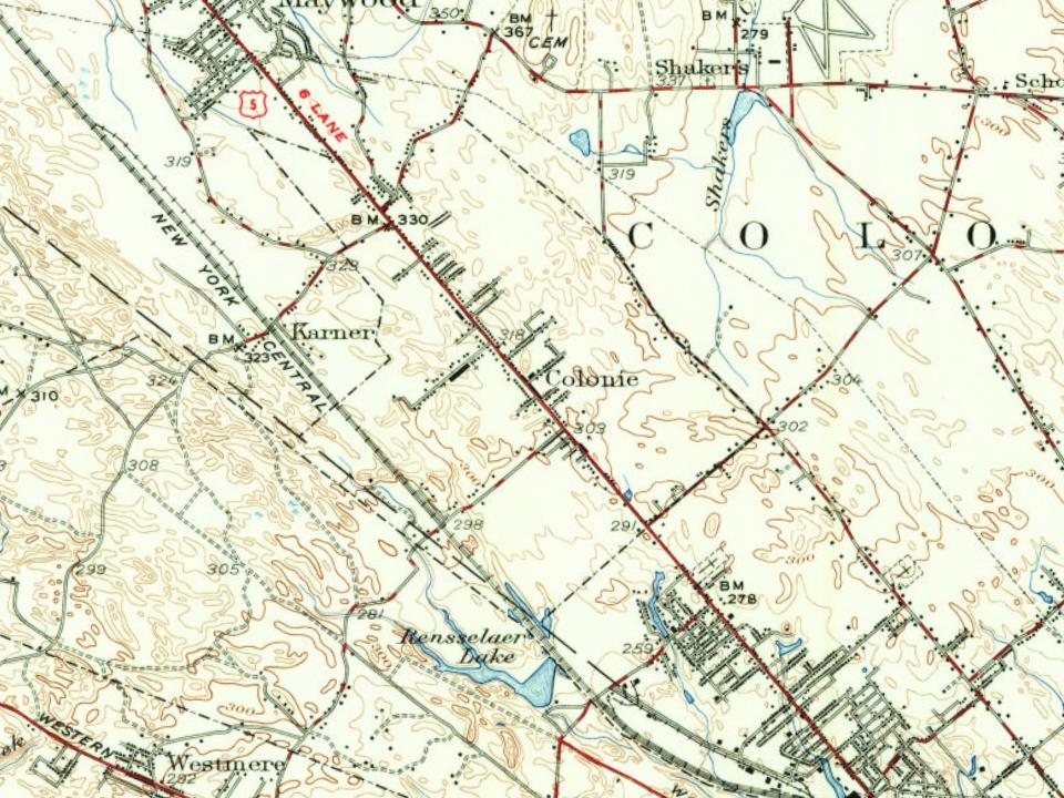
Most of Colonie was built recently: 9% of its homes predate 1940 and the median home dates from 1971. 45 places in town are on the National Register, among them four historic districts with 68 buildings between them. Below: 4 old photos and papers, maps from 1893 on, and the census since 1810.
Founding year: Wikidata. First post office: 1776.The full story ↓
History grade
What drives Colonie’s History grade
On its age, its old homes and the National Register, Colonie is more historic than 53% of U.S. towns, #653 of 758 in New York. Its National Register listings hold the grade up; its age pulls it down.
B−
HistoryA character grade: shown, never part of Colonie’s overall grade.
New York towns list more on the Register than most of the country (a typical New York town has 12.3 per 10,000 residents, the U.S. 2.4), so Colonie’s 15.9 sits near the middle of its state (53% of New York towns have fewer) while its 137 historic buildings outnumber those of 91% of U.S. towns.
NoteThe founding year comes from Wikidata alone; no second source gives 1895.
How sure. Graded on any two of the three inputs instead, the letter would range from C to B. The pre-1940 share (±1.2 points) is firm at this size.
Founding year: Wikidata (other dates in Quick answers). Homes: Census ACS 2020–24. National Register: National Park Service, May 2026 list; each listing counted once (boundary changes and added documentation belong to their listing), and a historic district counts its contributing buildings. How TownRatings grades history →
What stands out about Colonie’s past
Read from the archive, the National Register and the record. The page puts what stands out first.
National Park Service, National Register of Historic Places. Photos from Wikimedia Commons, credited on each place’s page.
Places that used to be
Lost post offices, old corners, places now gone and burying grounds
Seven other post offices opened and closed inside today’s town.
Albany
1776–today
Lishas Kill
1829–1902
Ireland Corners
1850–1871
Boght
1851–1861
Newtonville
1851–today
Loudonville
1871–1955
Shakers
1871–1904
Karner
1881–1912
Verdoy
1895–1901
Latham
1899–today
17701900today
Hamlets and corners on the map
Ballards Mobile Home CourtBoght CornersCentral Square Mobile Home ParkCrescent StationDunsbach FerryKarnerLathamLatham Mobile Home CourtLisha KillLone Pine Community Mobile Home ParkLoudon HeightsLoudonvilleMaywoodMenandsMohawk ViewNewtonvilleNorton Street Mobile Home ParkRoesslevilleShakersSunnyside Trailer CourtTen Oaks Mobile Home ParkVerdoyWackmans Mobile Home ParkWhitney Estates
Gone or out of use
Airport SchoolschoolAlbany-Schenectady Road Sewage Disposal PlantlocaleLatham Drive-InlocaleMenands Drive-InlocaleMohawk Drive-InlocaleNewtonville SchoolschoolPine Bush SchoolschoolSaint Colman's SchoolschoolSaratoga Drive-InlocaleSchool Number 21schoolSchool Number 6schoolTri-City Drive-Inlocale
14cemeteries and burying grounds inside Colonie
Albany RuralAlbany Rural Cemetery Soldiers' LotBeth EmethEvergreen MemorialImmaculate ConceptionMaplewoodMemory GardensOur Lady of AngelsSaint AgnesSaint Johns LutheranSaint NicholasSaint PatrickSickerWolf - Kemp
US Post Offices dataset (Blevins & Helbock, CC0). Places and cemeteries from the USGS Geographic Names Information System (2021).
Help out
Start Colonie’s collection
The first neighbors to add old photos shape how Colonie’s history is told.
Decades since 1900 with photos
00s10s20s30s40s50s60s70s80s90s
2 of 10 decades. The empty ones are waiting for someone’s album.
This area was once part of the Rensselaerwyck manor. The town of Colonie was formed in 1895 after the rural residents of the town of Watervliet opposed the state's proposal to transform the entire town into the city of Watervliet. The town and village of Green Island was also split off as a town from the town of Watervliet a year later and the village of West Troy that remained became the current city of Watervliet. All debts from the original town were divided proportionally between Green Island, Watervliet, and Colonie. Several lawsuits worked their way through the court system from the results of division. The original town of Watervliet was the "mother of towns" in Albany County, having once been all the land outside of the city of Albany within the county. All current towns either were formed directly or indirectly from a town formed from Watervliet. The central part of the town wa…
Nothing in the archives for these yearsWeddings on Main Street, storms, parades, school pictures, the old store. If it’s in your family album, it belongs here.
Nothing in the archives for these yearsWeddings on Main Street, storms, parades, school pictures, the old store. If it’s in your family album, it belongs here.
In 1895, according to Wikidata. Colonie’s post office opened in 1776, and the census of 1810 counted 1,406 people here.
How does Colonie rank for history?
Colonie is more historic than 53% of U.S. towns, #653 of 758 in New York. The History grade combines the town’s founding era, the share of homes built before 1940 and its National Register listings. It’s a character grade, so it isn’t part of the overall grade. How it works.
What is on the National Register in Colonie?
45 listings: 40 buildings, 4 historic districts with 68 contributing buildings, and 1 site. 137 historic buildings in all.
How old are the homes in Colonie?
9% of Colonie’s homes were built before 1940 (Census estimate, ±1.2 points), against a typical 27% for a New York town; the median home was built in 1971.
Founding dates: Wikidata, Wikipedia, the U.S. post office records of Blevins & Helbock (CC0) and the Census. Homes by year built: Census ACS 2020–24. National Register of Historic Places: National Park Service (list of May 22, 2026). Old photos, postcards and papers: Wikimedia Commons, the Library of Congress and other public archives, credited on each item’s page. Maps: U.S. Geological Survey historical topographic maps (via Esri) and Sanborn fire-insurance maps (Library of Congress). History text and census tables: Wikipedia (CC BY-SA 4.0). Places that used to be: USGS Geographic Names Information System (2021).
From Wikimedia Commons (11), the National Register of Historic Places (45), Wikipedia, Wikidata and Wikipedia for famous people, U.S. Geological Survey historical maps, U.S. Census counts (via Wikipedia), the US Post Offices dataset (Blevins & Helbock) and the USGS Geographic Names Information System. Archive images are copied here with their credits and licenses, shown on each photo’s page. Refreshed monthly.




 1968
 2007
 2007
 2007
 2007
 2004
 2004
 2004