Rochester dates to 1672, and 19% of its homes were built before 1940
More historic than 97% of U.S. towns · #90 of 758 in New York. What drives it
31 places in town are on the National Register, among them the Lake Mohonk Mountain House Complex, a National Historic Landmark, and five historic districts with 311 buildings between them. Below: 22 old photos and papers, maps from 1901 on, and the census since 1820.
Founding year: Wikidata; Wikipedia’s history section gives the same year. First post office: 1818.The full story ↓
History grade
What drives Rochester’s History grade
On its age, its old homes and the National Register, Rochester is more historic than 97% of U.S. towns, #90 of 758 in New York. All 3 inputs are above most U.S. towns; its age ranks highest and its share of homes from before 1940 lowest.
A+
HistoryA character grade: shown, never part of Rochester’s overall grade.
New York towns list more on the Register than most of the country (a typical New York town has 12.3 per 10,000 residents, the U.S. 2.4), so Rochester’s 524 sits above most of its state (92% of New York towns have fewer) while its 386 historic buildings outnumber those of 96% of U.S. towns.
How sure. Graded on any two of the three inputs instead, the letter would range from A to A+. The pre-1940 share is a Census survey estimate (±4.7 points). Two sources give 1672.
Founding year: Wikidata (other dates in Quick answers). Homes: Census ACS 2020–24. National Register: National Park Service, May 2026 list; each listing counted once (boundary changes and added documentation belong to their listing), and a historic district counts its contributing buildings. How TownRatings grades history →
What stands out about Rochester’s past
Read from the archive, the National Register and the record. The page puts what stands out first.
National Park Service, National Register of Historic Places. Photos from Wikimedia Commons, credited on each place’s page.
Places that used to be
Lost post offices, old corners, places now gone and burying grounds
Rochester had its own post office from 1820 to 1826. 11 other post offices opened and closed inside today’s town.
Pine Bush
1818–1852
Rochester
1820–1826
Accord
1826–today
Kyserike
1832–1954
Mombaccus
1872–1914
Mettacahonts
1881–1913
Tabasco
1883–1913
Pataukunk
1890–1914
Leibhardt
1891–1928
Whitfield
1891–1913
18101920today
Hamlets and corners on the map
AccordAlligervilleAtkins Mobile Home ParkCherrytownFantinekillGraniteGranite Road Mobile Home ParkHidden Forest Mobile Home ParkKyserikeLiebhardtMettacahontsMill HookMombaccusPalentownPataukunkPine BushPottervilleRiggsvilleSaint JosenTabascoWhitfieldYagerville
Gone or out of use
Alligerville Union SchoolschoolCherrytown SchoolschoolFather Divine LodgebuildingMettacahonts SchoolschoolMombaccus SchoolschoolPataukunk SchoolschoolPinebush SchoolschoolRochester Center SchoolschoolRochester SchoolschoolRochester SchoolschoolRock Hill SchoolschoolTabasco SchoolschoolWhitfield Schoolschool
Mombaccus was the Dutch name for the area that became the town of Rochester. It was first settled by Europeans in 1672. The name Rochester began with the issuance of a land patent in 1703. It became a town in 1788, and the formal establishment of the town of Rochester occurred in 1803.
Parts of Rochester were used to create the towns of Middletown in 1798 (now in Delaware County), Neversink in 1798 (now in Sullivan County), Wawarsing in 1806, and Gardiner in 1853.
Passages that mention Rochester, cut from the printed page as they were published.
Mattapoisett and Old Rochester, Massachusetts1907 · page 47Read the page →
Read the text
ure united. At a town meeting held June 4, 1700, "The inhabitance had before them the accompts of some of the chang that necessarily is coming and hath been in sd town of Rochester, and being sensable of the necessity of mony to be Received for a town stock or Treasury, the inhabitance voted that a Rat of thirty shillings be raised to defray the necessary chang arising in sd town of Rochester, in the year 1700."
Text read by machine from the scan; it may contain errors.
Mattapoisett and Old Rochester, Massachusetts1907 · page 78Read the page →
Read the text
78 Mattapoisett and Old Rochester The second parish division in Old Rochester took place July 6, 1739, when the town of Wareham was incorporated. The same year a church was established there, consisting of thirty-three members dismissed from the First Church of Rochester.
Text read by machine from the scan; it may contain errors.
Scans and text from the Internet Archive. Books published in 1930 or earlier, which are in the public domain.
Timeline
Rochester, 1672 to 2010
Woven from the archive, old maps, post office records, the National Register and the people born here.
Nothing in the archives for these yearsWeddings on Main Street, storms, parades, school pictures, the old store. If it’s in your family album, it belongs here.
In 1672, according to Wikidata and Wikipedia’s history of the town. Rochester’s post office opened in 1818, and the census of 1820 counted 2,063 people here.
How does Rochester rank for history?
Rochester is more historic than 97% of U.S. towns, #90 of 758 in New York. The History grade combines the town’s founding era, the share of homes built before 1940 and its National Register listings. It’s a character grade, so it isn’t part of the overall grade. How it works.
What is on the National Register in Rochester?
31 listings: 26 buildings and 5 historic districts with 311 contributing buildings. 386 historic buildings in all.
How old are the homes in Rochester?
19% of Rochester’s homes were built before 1940 (Census estimate, ±4.7 points), against a typical 27% for a New York town; the median home was built in 1975.
Founding dates: Wikidata, Wikipedia, the U.S. post office records of Blevins & Helbock (CC0) and the Census. Homes by year built: Census ACS 2020–24. National Register of Historic Places: National Park Service (list of May 22, 2026). Old photos, postcards and papers: Wikimedia Commons, the Library of Congress and other public archives, credited on each item’s page. Maps: U.S. Geological Survey historical topographic maps (via Esri) and Sanborn fire-insurance maps (Library of Congress). History text and census tables: Wikipedia (CC BY-SA 4.0). Places that used to be: USGS Geographic Names Information System (2021).
From Wikimedia Commons (5), the Library of Congress (17), the National Register of Historic Places (31), Wikipedia, U.S. Geological Survey historical maps, U.S. Census counts (via Wikipedia), the US Post Offices dataset (Blevins & Helbock), the USGS Geographic Names Information System and old county and town histories (Internet Archive). Archive images are copied here with their credits and licenses, shown on each photo’s page. Refreshed monthly.


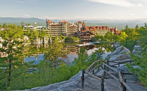 ★ Landmark


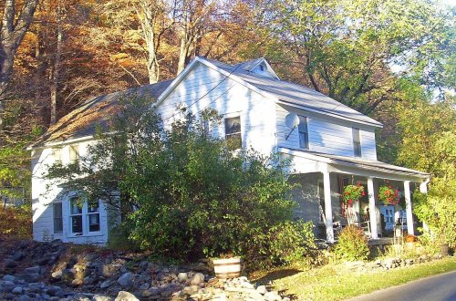


 1795
 1795
 1795
 1905
 1908
 1908
 1910
 1910
 1910
 1910
 1911
 1943
 1943
 1943
 1943
 1943


