San Diego dates to 1769, and 92 of its places are on the National Register
More historic than 88% of U.S. towns · #11 of 847 in California. What drives it
Most of San Diego was built recently: 6% of its homes predate 1940 and the median home dates from 1979. 92 places in town are on the National Register, among them 9 National Historic Landmarks and ten historic districts with 1,055 buildings between them. Below: 14 old photos and papers, maps from 1887 on, and the census since 1850.
Founding year: Wikidata. First post office: 1849.The full story ↓
History grade
What drives San Diego’s History grade
On its age, its old homes and the National Register, San Diego is more historic than 88% of U.S. towns, #11 of 847 in California. Its age holds the grade up; its share of homes from before 1940 pulls it down.
A
HistoryA character grade: shown, never part of San Diego’s overall grade.
Among the 400 U.S. cities of 100,000 or more, San Diego ranks #76 on History.
Few California towns list much on the Register (a typical California town has 0.0 per 10,000 residents, the U.S. 2.4), so San Diego’s 8.2 sits above most of its state (90% of California towns have fewer) while its 1,141 historic buildings outnumber those of 99% of U.S. towns.
NoteThe founding year comes from Wikidata alone; no second source gives 1769.
How sure. Graded on any two of the three inputs instead, the letter would range from B+ to A+. The pre-1940 share (±0.3 points) is firm at this size. A citywide figure averages neighborhoods that differ a lot.
Founding year: Wikidata (other dates in Quick answers). Homes: Census ACS 2020–24. National Register: National Park Service, May 2026 list; each listing counted once (boundary changes and added documentation belong to their listing), and a historic district counts its contributing buildings. How TownRatings grades history →
What stands out about San Diego’s past
Read from the archive, the National Register and the record. The page puts what stands out first.
The country’s official list of buildings and places worth saving. 9 are National Historic Landmarks, the highest tier. Boundary changes and added documentation are counted with their listing.
National Park Service, National Register of Historic Places. Photos from Wikimedia Commons, credited on each place’s page.
Places that used to be
Lost post offices, old corners, places now gone and burying grounds
San Diego’s post office has been open since 1849. 22 other post offices opened and closed inside today’s town.
San Diego
1849–today
South San Diego
1869–1876
North San Diego
1870–1943
Bernardo
1872–1918
San Pasqual
1874–1901
Tia Juana
1876–1904
Emery
1882–1887
Linda Vista
1886–1945
Black Mountain
1888–1903
El Nido
1888–1900
18401930today
Hamlets and corners on the map
Allied GardensBarrio LoganBay ParkBayside VillageBrooklyn HeightsCampland on the Bay Trailer ParkChollas CreekChollas ViewClairemontCollege HeightsDe Anza Trailer HarborDel CerroEast San DiegoEaster CrossElviraEmerald HillsEncantoFiesta ShoresFive PointsFleetridgeFort RosecransFruitdaleGolden HillGrant Hill
Gone or out of use
Battery CalefmilitaryBattery FettermanmilitaryBattery McGrathmilitaryBattery WhistlermilitaryBattery WhitemilitaryBattery WilkesonmilitaryBrown Military AcademyschoolCamp CallanmilitaryCarroll Canyon QuarrymineClairmont Community HospitalhospitalCulvarwells WharflocaleDel Mar AirportairportFort GuijarrosmilitaryFort Pio PicomilitaryFort StocktonmilitaryHarborview Medical CenterhospitalHoward RanchlocaleLa Jolla Hospitalhospital
17cemeteries and burying grounds inside San Diego
All Souls Episcopal Church ColumbariumCalvaryCarmel ValleyCypress View MausoleumEl Camino Memorial ParkEl Campo SantoFirst United Methodist Church ColumbariumFort Rosecrans NationalGreenwoodHoly CrossHome of PeaceMiramar NationalMount HopeMount OlivetPresidio HillSaint Dunstan's Episcopal Church ColumbariumSan Pasqual Indian
US Post Offices dataset (Blevins & Helbock, CC0). Places and cemeteries from the USGS Geographic Names Information System (2021).
What has been referred to as the San Dieguito complex was established in the area at least 9,000 years ago. The Kumeyaay may have culturally evolved from this complex or migrated into the area around 1000 C.E. Archaeologist Malcolm Rogers hypothesized that the early cultures of San Diego were separate from the Kumeyaay, but this claim is disputed. Rogers later reevaluated his claims, yet they were influential in shaping historical tellings of early San Diego history.
Passages that mention San Diego, cut from the printed page as they were published.
An illustrated history of Southern California1890Read the page →
Read the text
stockholder of the College Hill Land Association. He is a stockholder of the Coronado Beach Company. He was one of the incorporators of the San Diego National Bank, and the Bank of Escondido, and a stockholder in the Bank of Elsinore and the Exchange Bank of Elsinore. He was one of the incorporators and is a director in the Coronado Ferry Company,
Text read by machine from the scan; it may contain errors.
The city and county of San Diego1888 · page 194Read the page →
Read the text
one of the most active and public-spirited of San Diego's citizens He has been the leading spirit in most of the important enterprises that have been organized here. He was one of the original incorporators ot the San Diego Street Railroad Co., of the San Diego and Coronado Ferry Co., of the San Diego Lumber Co., of the West Coast Lumber Co. , and of the San Diego and Old Town Railroad Co. He has also been largely interested in a great many land companies, including Escondido Land Co., the San Marcos Land Co. , the Cottage Hill Land
Text read by machine from the scan; it may contain errors.
An illustrated history of Southern California1890Read the page →
Read the text
with nearly all the public enterprises inaugurated in San Diego; among others may be mentioned the San Diego & Gila Kailroad Company, which in 1856 made the first survey from Sun Diego to the Colorado river; the San Diego & Los Angeles Railroad Company, which made the first railroad survey between San Diego and Los Angeles; the Fort Yuma wagon road, built
Text read by machine from the scan; it may contain errors.
Scans and text from the Internet Archive. Books published in 1930 or earlier, which are in the public domain.
Timeline
San Diego, 1769 to 1961
Woven from the archive, old maps, post office records, the National Register and the people born here.
Nothing in the archives for these yearsWeddings on Main Street, storms, parades, school pictures, the old store. If it’s in your family album, it belongs here.
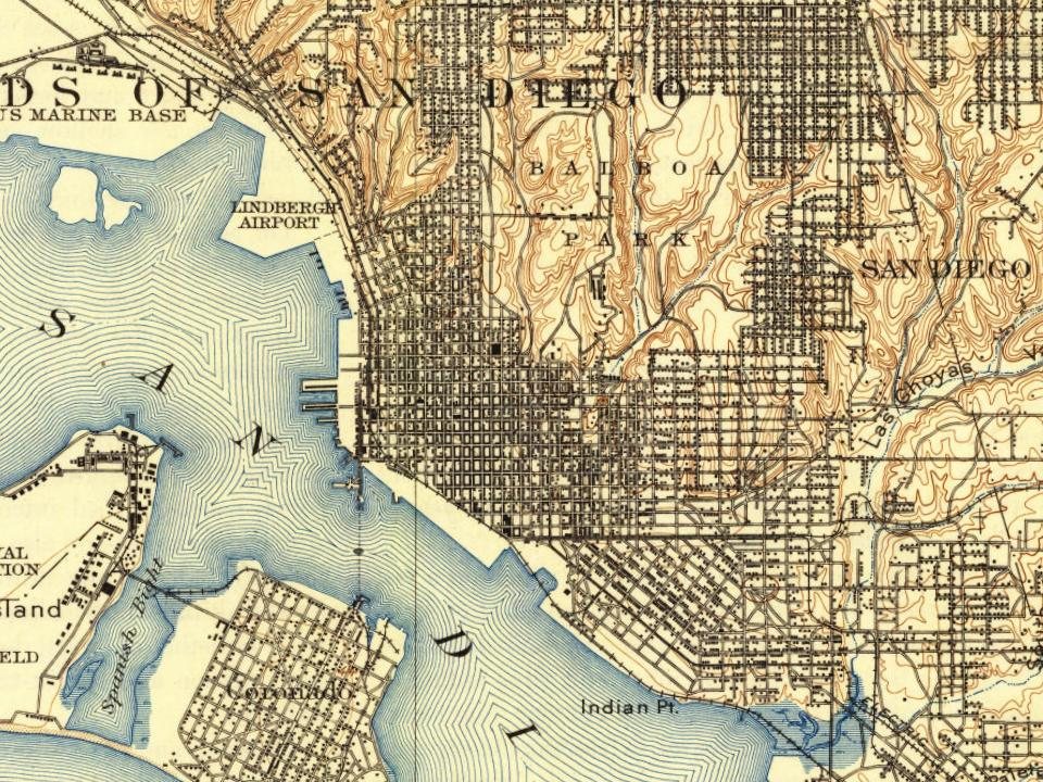
Every edition of the U.S. Geological Survey’s map of San Diego. Tap a year, or press play to watch the town change.
1904San Diego sheet · 1:62,500
U.S. Geological Survey historical topographic maps (public domain), via Esri’s collection of the scans. The red ring marks the center of San Diego.
Every building
San Diego, building by building, 1887–1921
Fire insurance maps drew every building, what it was made of and what it was used for, so insurers could price the risk of fire. Pick a year, then a sheet.
In 1769, according to Wikidata. San Diego’s post office opened in 1849, and the census of 1850 counted 500 people here.
How does San Diego rank for history?
San Diego is more historic than 88% of U.S. towns, #11 of 847 in California. The History grade combines the town’s founding era, the share of homes built before 1940 and its National Register listings. It’s a character grade, so it isn’t part of the overall grade. How it works.
What is on the National Register in San Diego?
92 listings, 9 of them National Historic Landmarks: 60 buildings, 17 historic districts with 1,055 contributing buildings, 3 sites, and 12 structures. 1,141 historic buildings in all.
How old are the homes in San Diego?
6% of San Diego’s homes were built before 1940 (Census estimate), against a typical 3.4% for a California town; the median home was built in 1979.
Founding dates: Wikidata, Wikipedia, the U.S. post office records of Blevins & Helbock (CC0) and the Census. Homes by year built: Census ACS 2020–24. National Register of Historic Places: National Park Service (list of May 22, 2026). Old photos, postcards and papers: Wikimedia Commons, the Library of Congress and other public archives, credited on each item’s page. Maps: U.S. Geological Survey historical topographic maps (via Esri) and Sanborn fire-insurance maps (Library of Congress). History text and census tables: Wikipedia (CC BY-SA 4.0). Places that used to be: USGS Geographic Names Information System (2021).
From Wikimedia Commons (5), the Library of Congress (9), Wikidata (17), the National Register of Historic Places (92), Wikipedia, Wikidata and Wikipedia for famous people, U.S. Geological Survey historical maps, U.S. Census counts (via Wikipedia), the US Post Offices dataset (Blevins & Helbock), the USGS Geographic Names Information System, Sanborn fire insurance maps (Library of Congress) and old county and town histories (Internet Archive). Archive images are copied here with their credits and licenses, shown on each photo’s page. Refreshed monthly.


 ★ Landmark
 ★ Landmark
 ★ Landmark
 ★ Landmark
 ★ Landmark
 ★ Landmark
 ★ Landmark
 ★ Landmark




 1895
 1898
 1902
 1904
 1905
 1905
 1906
 1913
 1915
 1915