19% of North Smithfield’s homes were built before 1940
More historic than 88% of U.S. towns · #18 of 38 in Rhode Island. What drives it
9 places in town are on the National Register, among them four historic districts with 234 buildings between them. Below: 5 old photos and papers, maps from 1889 on, and the census since 1870.
On its age, its old homes and the National Register, North Smithfield is more historic than 88% of U.S. towns, #18 of 38 in Rhode Island. All 2 inputs are above most U.S. towns; its National Register listings ranks highest and its share of homes from before 1940 lowest.
A
HistoryA character grade: shown, never part of North Smithfield’s overall grade.
Rhode Island towns list more on the Register than most of the country (a typical Rhode Island town has 94.7 per 10,000 residents, the U.S. 2.4), so North Smithfield’s 195 sits above most of its state (71% of Rhode Island towns have fewer) while its 248 historic buildings outnumber those of 94% of U.S. towns.
How sure. Graded on two of the three inputs, so a change in either one moves the letter more than it would with three. The pre-1940 share is a Census survey estimate (±4.6 points).
Founding year: our sources. Homes: Census ACS 2020–24. National Register: National Park Service, May 2026 list; each listing counted once (boundary changes and added documentation belong to their listing), and a historic district counts its contributing buildings. How TownRatings grades history →
What stands out about North Smithfield’s past
Read from the archive, the National Register and the record. The page puts what stands out first.
National Park Service, National Register of Historic Places. Photos from Wikimedia Commons, credited on each place’s page.
On the map
North Smithfield on the map, 1889 to 1999
Every edition of the U.S. Geological Survey’s map of North Smithfield. Tap a year, or press play to watch the town change.
1889Burrillville sheet · 1:62,500
U.S. Geological Survey historical topographic maps (public domain), via Esri’s collection of the scans. The red ring marks the center of North Smithfield.
Places that used to be
Lost post offices, old corners and burying grounds
Another post office, Slater's Village, opened and closed inside today’s town.
20cemeteries and burying grounds inside North Smithfield
Ananias Mowry LotBuxtonCaptain James BuxtonElijah Smith LotGideon Sayles LotIsreal Aldrich LotJashub Wing LotJoseph Inman LotMann - Holley LotsMorrison - Streeter LotMowry - Hall LotOld Aldrich Burial GroundsOld TownRichard Mowry LotSaint John'sSlatersvilleSmith LotStephen Mowry LotSterry Young LotUnion
See all 20
Ananias Mowry Lot · Buxton Cemetery · Captain James Buxton Cemetery · Elijah Smith Lot · Gideon Sayles Lot · Isreal Aldrich Lot · Jashub Wing Lot · Joseph Inman Lot · Mann - Holley Lots · Morrison - Streeter Lot · Mowry - Hall Lot · Old Aldrich Burial Grounds · Old Town Burial Ground · Richard Mowry Lot · Saint John's Cemetery · Slatersville Cemetery · Smith Lot · Stephen Mowry Lot · Sterry Young Lot · Union Cemetery
US Post Offices dataset (Blevins & Helbock, CC0). Places and cemeteries from the USGS Geographic Names Information System (2021).
In the 17th century British colonists settled in North Smithfield developing a farming community that they named after Smithfield, London in England. The town was part of Smithfield, Rhode Island until it was incorporated as North Smithfield in 1871. The first colonization occurred after a Native American, "William Minnian" (also known as "Quashawannamut") a Praying Indian from Punkkupage Massachusetts Bay, on May 14, 1666, and again in 1669 with the permission of King Philip, deeded approximately 2,000 acres" to John Mowry and Edward Inman who partnered with Nathaniel Mowry, John Steere, and Thomas Walling in dividing up the purchased tract. During King Philip's War in 1676 Connecticut militia forces killed the last Narragansett sachem, Queen Quaiapen, and Stonewall John in Mattity Swamp in what is now North Smithfield in the Second Battle of Nipsachuck. In the early 18th century, a Q…
Passages that mention North Smithfield, cut from the printed page as they were published.
History of Providence County, Rhode Island1891Read the page →
Read the text
thus indicating the large amount flowing into the United States Treasury from the entire county. Mr. Mowry was elected to the Rhode Island house of representatives in 1868, and served continuously until 1871. He represented the town of North Smithfield in questions arising from a division of the town of Smithfield, and was elected a committee to act jointly with others from the towns of Lincoln, Smithfield and Woonsocket to prepare a written history of the old town of Smithfield. Mr. Mowry on a division of above town be-
Text read by machine from the scan; it may contain errors.
History of Providence County, Rhode Island1891 · page 486Read the page →
Read the text
The town of North Smithfield, being the northernmost of the towns carved out of old Smithfield, comprises about 25 square miles, and its valuation, in the act of division, was $1,762,443. Within its limits is that portion of the Waterf ord Woolen Mills which lie in Rhode Island, a valuable but unimproved water power at Branch Village, the Forestdale Cotton Mills, the village of Slatersville with its busy mills, and the beautiful Union Village, which, although now deserted by trade,
Text read by machine from the scan; it may contain errors.
Scans and text from the Internet Archive. Books published in 1930 or earlier, which are in the public domain.
Timeline
North Smithfield, 1820 to 1980
Woven from the archive, old maps, post office records, the National Register and the people born here.
Nothing in the archives for these yearsWeddings on Main Street, storms, parades, school pictures, the old store. If it’s in your family album, it belongs here.
North Smithfield is more historic than 88% of U.S. towns, #18 of 38 in Rhode Island. The History grade combines the town’s founding era, the share of homes built before 1940 and its National Register listings. It’s a character grade, so it isn’t part of the overall grade. How it works.
What is on the National Register in North Smithfield?
9 listings: 5 buildings and 4 historic districts with 234 contributing buildings. 248 historic buildings in all.
How old are the homes in North Smithfield?
19% of North Smithfield’s homes were built before 1940 (Census estimate, ±4.6 points), against a typical 20% for a Rhode Island town; the median home was built in 1972.
Founding dates: Wikidata, Wikipedia, the U.S. post office records of Blevins & Helbock (CC0) and the Census. Homes by year built: Census ACS 2020–24. National Register of Historic Places: National Park Service (list of May 22, 2026). Old photos, postcards and papers: Wikimedia Commons, the Library of Congress and other public archives, credited on each item’s page. Maps: U.S. Geological Survey historical topographic maps (via Esri) and Sanborn fire-insurance maps (Library of Congress). History text and census tables: Wikipedia (CC BY-SA 4.0). Places that used to be: USGS Geographic Names Information System (2021).
From Wikimedia Commons (12), the National Register of Historic Places (9), Wikipedia, Wikidata and Wikipedia for famous people, U.S. Geological Survey historical maps, U.S. Census counts (via Wikipedia), the US Post Offices dataset (Blevins & Helbock), the USGS Geographic Names Information System and old county and town histories (Internet Archive). Archive images are copied here with their credits and licenses, shown on each photo’s page. Refreshed monthly.


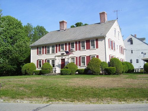
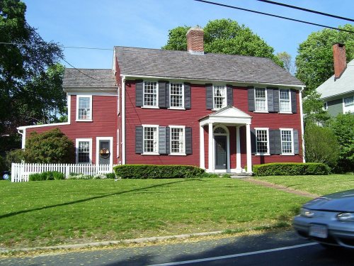


 c. 1975
 1977
 1977
 1977
 2008
 2008
 2008
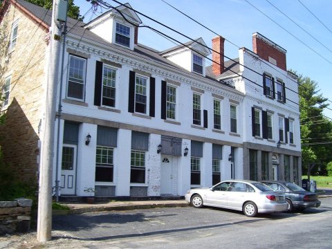 2008
 2008
 2007
 2006
