Woonsocket dates to 1867, and 41% of its homes were built before 1940
More historic than 80% of U.S. towns · #26 of 38 in Rhode Island. What drives it
43 places in town are on the National Register, among them ten historic districts with 405 buildings between them. Below: 28 old photos and papers, maps from 1889 on, and the census since 1870.
Founding year: Wikidata. First post office: 1827.The full story ↓
History grade
What drives Woonsocket’s History grade
On its age, its old homes and the National Register, Woonsocket is more historic than 80% of U.S. towns, #26 of 38 in Rhode Island. Its share of homes from before 1940 holds the grade up; its age pulls it down.
A−
HistoryA character grade: shown, never part of Woonsocket’s overall grade.
Rhode Island towns list more on the Register than most of the country (a typical Rhode Island town has 94.7 per 10,000 residents, the U.S. 2.4), so Woonsocket’s 104 sits near the middle of its state (53% of Rhode Island towns have fewer) while its 452 historic buildings outnumber those of 97% of U.S. towns.
How sure. Graded on any two of the three inputs instead, the letter would range from B to A. The pre-1940 share is a Census survey estimate (±3.5 points). Two sources give 1867.
Founding year: Wikidata (other dates in Quick answers). Homes: Census ACS 2020–24. National Register: National Park Service, May 2026 list; each listing counted once (boundary changes and added documentation belong to their listing), and a historic district counts its contributing buildings. How TownRatings grades history →
What stands out about Woonsocket’s past
Read from the archive, the National Register and the record. The page puts what stands out first.
Nothing in the archives for these yearsWeddings on Main Street, storms, parades, school pictures, the old store. If it’s in your family album, it belongs here.
Before the arrival of European settlers in northern Rhode Island during the 17th century, today's Woonsocket region was inhabited by three Native American tribes: the Nipmuc (Cowesett), Wampanoag, and Narragansett. In 1661, the English theologian Roger Williams purchased the area from the "Coweset and Nipmucks", and in a letter referred to modern day Woonsocket as Niswosakit.
Other possible derivations of the name include several Nipmuc geographic names from nearby Massachusetts. These include Woonksechocksett, from Worcester County meaning "fox country", and Wannashowatuckqut, also from Worcester County, meaning "at the fork of the river". Another theory proposes that the city was named after Woonsocket Hill in neighboring North Smithfield.
Passages that mention Woonsocket, cut from the printed page as they were published.
History of Providence County, Rhode Island1891 · page 208Read the page →
Read the text
At the June town meeting, 1870, it was voted that "a committee consisting of five persons be appointed to confer with the committee from the town of Woonsocket in the matter of setting off and annexing to said town of Woonsocket a portion of the town of Smithfield." A vote was taken on this subject, there being 42 in favor, and 193 opposed. January 21st, 1871, the question of dividing the town of Smithfield into three towns was voted for, there being 111 in favor and 33 opposed.
Text read by machine from the scan; it may contain errors.
History of Providence County, Rhode Island1891 · page 283Read the page →
Read the text
reverted to the former owners of the land. It is said that by the above sale the holders of canal stock realized their only dividend, about one dollar per share. ^ Through the town of Woonsocket the course of this almost-forgotten thoroughfare was, when not in the channel of the stream, mainly on the north side of the river. It thus passed out of the stream, after leaving the Massachusetts line, at Buffum's bridge, thence by trench to a point above the Doctor Ballou bridge, where it again entered the
Text read by machine from the scan; it may contain errors.
Scans and text from the Internet Archive. Books published in 1930 or earlier, which are in the public domain.
Timeline
Woonsocket, 1761 to 1977
Woven from the archive, old maps, post office records, the National Register and the people born here.
Every edition of the U.S. Geological Survey’s map of Woonsocket. Tap a year, or press play to watch the town change.
1889Blackstone sheet · 1:62,500
U.S. Geological Survey historical topographic maps (public domain), via Esri’s collection of the scans. The red ring marks the center of Woonsocket.
Every building
Woonsocket, building by building, 1892–1911
Fire insurance maps drew every building, what it was made of and what it was used for, so insurers could price the risk of fire. Pick a year, then a sheet.
In 1867, according to Wikidata. Woonsocket’s post office opened in 1827, and the census of 1870 counted 11,527 people here.
How does Woonsocket rank for history?
Woonsocket is more historic than 80% of U.S. towns, #26 of 38 in Rhode Island. The History grade combines the town’s founding era, the share of homes built before 1940 and its National Register listings. It’s a character grade, so it isn’t part of the overall grade. How it works.
What is on the National Register in Woonsocket?
43 listings: 31 buildings, 10 historic districts with 405 contributing buildings, 2 structures, and 1 object. 452 historic buildings in all.
How old are the homes in Woonsocket?
41% of Woonsocket’s homes were built before 1940 (Census estimate, ±3.5 points), against a typical 20% for a Rhode Island town; the median home was built in 1952.
Founding dates: Wikidata, Wikipedia, the U.S. post office records of Blevins & Helbock (CC0) and the Census. Homes by year built: Census ACS 2020–24. National Register of Historic Places: National Park Service (list of May 22, 2026). Old photos, postcards and papers: Wikimedia Commons, the Library of Congress and other public archives, credited on each item’s page. Maps: U.S. Geological Survey historical topographic maps (via Esri) and Sanborn fire-insurance maps (Library of Congress). History text and census tables: Wikipedia (CC BY-SA 4.0). Places that used to be: USGS Geographic Names Information System (2021).
From Wikimedia Commons (10), the Library of Congress (20), Wikidata (6), the National Register of Historic Places (44), Wikipedia, Wikidata and Wikipedia for famous people, U.S. Geological Survey historical maps, U.S. Census counts (via Wikipedia), the US Post Offices dataset (Blevins & Helbock), the USGS Geographic Names Information System, Sanborn fire insurance maps (Library of Congress) and old county and town histories (Internet Archive). Archive images are copied here with their credits and licenses, shown on each photo’s page. Refreshed monthly.




 1855
 c. 1860
 1886
 1886
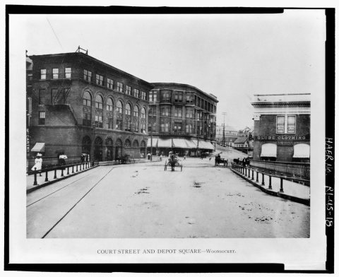 1896
 1896
 1912
 1940
 1940
 1940
 1940
 1940
 1940
 1940
 1940
 1940
 1940
 1940
 1940
 1940
 1940
 1940
 1940
 1940
 1940
 1940
 1978
 1978
 2005
 2005