Lewiston’s post office opened in 1807, and 12% of its homes were built before 1940
More historic than 65% of U.S. towns · #566 of 758 in New York. What drives it
3 places in town are on the National Register, among them a historic district with 2 buildings. Below: 11 old photos and papers, maps from 1894 on, and the census since 1820.
The Lewiston post office opened in 1807, the earliest record of the town by name. Wikidata gives 1818. Two smaller post offices, Dickersonville (1851) and Modeltown (1894), opened inside today’s town and later closed.
First census: 869 in 18202020 census: 15,944219 years
How historic is Lewiston?
B
More historic than 65% of U.S. towns, on its age, its old homes and the National Register.
Founding year: the first Lewiston post office (Blevins & Helbock, CC0). Wikidata: 1818.The full story ↓
History grade
What drives Lewiston’s History grade
On its age, its old homes and the National Register, Lewiston is more historic than 65% of U.S. towns, #566 of 758 in New York. Its age holds the grade up; its National Register listings pull it down.
B
HistoryA character grade: shown, never part of Lewiston’s overall grade.
New York towns list more on the Register than most of the country (a typical New York town has 12.3 per 10,000 residents, the U.S. 2.4), so Lewiston’s 2.5 sits below most of its state (27% of New York towns have fewer) while its 4 historic buildings outnumber those of 68% of U.S. towns.
How sure. Graded on any two of the three inputs instead, the letter would range from B− to B+. The pre-1940 share (±2.3 points) is firm at this size. The founding year is the first post office, not a stated founding date; Wikidata’s 1818 falls in the same era, so the grade doesn’t depend on which one is used.
Founding year: the first post office (other dates in Quick answers). Homes: Census ACS 2020–24. National Register: National Park Service, May 2026 list; each listing counted once (boundary changes and added documentation belong to their listing), and a historic district counts its contributing buildings. How TownRatings grades history →
What stands out about Lewiston’s past
Read from the archive, the National Register and the record. The page puts what stands out first.
Lost post offices, old corners, places now gone and burying grounds
Lewiston’s post office has been open since 1807. Two other post offices opened and closed inside today’s town.
Lewiston
1807–today
Dickersonville
1851–1877
Niagara University
1887–today
Modeltown
1894–1946
Stella Niagara
1910–today
Model City
1946–today
18001910today
Hamlets and corners on the map
Colonial VillageDickersonvilleEscarpmentLewiston HeightsModel CityRiverside ManorsRumsey RidgeStella NiagaraVarsity Village
Gone or out of use
Nike Site NF-03CmilitarySchool Number 11schoolSchool Number 12schoolSchool Number 2schoolSchool Number 3schoolSchool Number 4schoolSchool Number 5schoolSchool Number 9school
7cemeteries and burying grounds inside Lewiston
Gate of HeavenHoly TrinityLewiston VillageRiverdaleSaint MichaelsStella Niagara Sisters of Saint FrancisTemple Beth Israel
US Post Offices dataset (Blevins & Helbock, CC0). Places and cemeteries from the USGS Geographic Names Information System (2021).
On the map
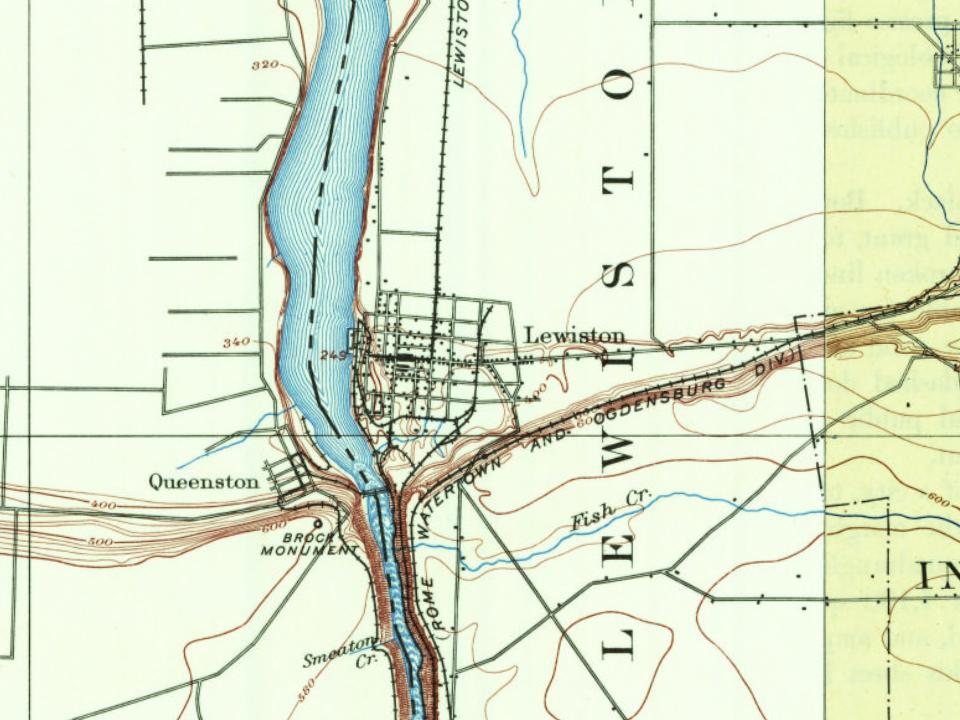
Lewiston on the map, 1894 to 1980
Every edition of the U.S. Geological Survey’s map of Lewiston. Tap a year, or press play to watch the town change.
1894Niagara Falls sheet · 1:62,500
U.S. Geological Survey historical topographic maps (public domain), via Esri’s collection of the scans. The red ring marks the center of Lewiston.
Timeline
Lewiston, 1807 to 1995
Woven from the archive, old maps, post office records, the National Register and the people born here.
The Town of Lewiston was formed in 1818 from the town of Cambria. Lewiston was the first European settlement in Western New York. A French explorer by the name of Étienne Brûlé arrived in 1615.
Passages that mention Lewiston, cut from the printed page as they were published.
History of Niagara county, N. Y., with illustrations descriptive of its scenery, private residences, public buildings, fine blocks, and important manufactories, and portraits of old pioneers and prominent residents1878 · page 262Read the page →
Read the text
Lewiston village was incorporated April iSth, 1843, the following being a copy of the act : "The district of country in the county of Niagara comprised within the town of Lewiston and bounded as follows: Bounded on the north by lot number twenty of the Niagara tract; on the east by lots number forty-one and forty-two, township fourteen, ninth range, of the Holland Land Company's land; on the south by lot number
Text read by machine from the scan; it may contain errors.
History of Niagara county, N. Y., with illustrations descriptive of its scenery, private residences, public buildings, fine blocks, and important manufactories, and portraits of old pioneers and prominent residents1878 · page 256Read the page →
Read the text
running southerly on the west line of said section thirtytwo in a direct line to the south bounds of said town of Cambria, be and is hereby erected into a separate town by the name of Lewiston, and the first town meeting in the said town of Lewiston shall be held at the house of Sparrow Sage; and that the remainder of the said town of Cambria shall be and remain a separate town by the name of Cambria, and the next town meeting shall be
Text read by machine from the scan; it may contain errors.
Souvenir history of Niagara County, New York1902 · page 188Read the page →
Read the text
Avenue, while below the hill this present avenue was known as Spring Street. That section of the present Main Street in the former village of Suspension Bridge was known as Lewiston Avenue, while in the village of Niagara Falls it was known as Ontario Street. Up to 1850 all the business of the village of Suspension Bridge was on Spring Street, but in the next few years it began to creep up the hill.
Text read by machine from the scan; it may contain errors.
Souvenir history of Niagara County, New York1902 · page 184Read the page →
Read the text
from Lockport building the wing extending to the north, and the Buffalo line building a wing that extended east, but which has since been changed. The company that built the railroad to Lewiston was incorporated September 9, 1852, and was known as the Niagara Falls & Lake Ontario Railroad Company, its inspiration being to reach the lake at Youngstown. The work of this company commanded much attention because of the great cut it made through the rock
Text read by machine from the scan; it may contain errors.
Scans and text from the Internet Archive. Books published in 1930 or earlier, which are in the public domain.
By decade
Lewiston, decade by decade
2 decades in the archive, from the 1870s to the 1900s. Scroll each row; tap a photo for its story.
Nothing in the archives for these yearsWeddings on Main Street, storms, parades, school pictures, the old store. If it’s in your family album, it belongs here.
The Lewiston post office opened in 1807, the earliest record of the town by name (U.S. post office records). Wikidata gives 1818.
How does Lewiston rank for history?
Lewiston is more historic than 65% of U.S. towns, #566 of 758 in New York. The History grade combines the town’s founding era, the share of homes built before 1940 and its National Register listings. It’s a character grade, so it isn’t part of the overall grade. How it works.
What is on the National Register in Lewiston?
Three places: the Frontier House (listed 1974), the Niagara Power Project Historic District (2017) and the First Presbyterian Church of Lewiston and Lewiston Village Cemetery (2019).
How old are the homes in Lewiston?
12% of Lewiston’s homes were built before 1940 (Census estimate, ±2.3 points), against a typical 27% for a New York town; the median home was built in 1968.
Founding dates: Wikidata, Wikipedia, the U.S. post office records of Blevins & Helbock (CC0) and the Census. Homes by year built: Census ACS 2020–24. National Register of Historic Places: National Park Service (list of May 22, 2026). Old photos, postcards and papers: Wikimedia Commons, the Library of Congress and other public archives, credited on each item’s page. Maps: U.S. Geological Survey historical topographic maps (via Esri) and Sanborn fire-insurance maps (Library of Congress). History text and census tables: Wikipedia (CC BY-SA 4.0). Places that used to be: USGS Geographic Names Information System (2021).
From Wikimedia Commons (1), the Library of Congress (10), the National Register of Historic Places (3), Wikipedia, Wikidata and Wikipedia for famous people, U.S. Geological Survey historical maps, U.S. Census counts (via Wikipedia), the US Post Offices dataset (Blevins & Helbock), the USGS Geographic Names Information System, Sanborn fire insurance maps (Library of Congress) and old county and town histories (Internet Archive). Archive images are copied here with their credits and licenses, shown on each photo’s page. Refreshed monthly.




 1900
 1900
 1900
 Date?
 Date?
 Date?
 Date?
 Date?
 Date?


