More historic than 40% of U.S. towns · #706 of 758 in New York. What drives it
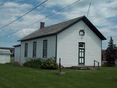
Its Register listing is the Town of Niagara District School No. 2. Most of Niagara was built recently: 9% of its homes predate 1940 and the median home dates from 1967. Below: 2 old photos and papers, maps from 1897 on, and the census since 1820.
On its age, its old homes and the National Register, Niagara is more historic than 40% of U.S. towns, #706 of 758 in New York. Its National Register listings hold the grade up; its share of homes from before 1940 pulls it down.
C+
HistoryA character grade: shown, never part of Niagara’s overall grade.
New York towns list more on the Register than most of the country (a typical New York town has 12.3 per 10,000 residents, the U.S. 2.4), so Niagara’s 2.6 sits below most of its state (27% of New York towns have fewer) while its 2 historic buildings outnumber those of 60% of U.S. towns.
How sure. Graded on two of the three inputs, so a change in either one moves the letter more than it would with three. The pre-1940 share is a Census survey estimate (±3.3 points).
Founding year: our sources. Homes: Census ACS 2020–24. National Register: National Park Service, May 2026 list; each listing counted once (boundary changes and added documentation belong to their listing), and a historic district counts its contributing buildings. How TownRatings grades history →
What stands out about Niagara’s past
Read from the archive, the National Register and the record. The page puts what stands out first.
The Town of Niagara was founded in 1812 (originally as the "Town of Schlosser" after the local fortification Fort Schlosser and its first commander Captain Joseph Schlosser, a German officer in the British Army from the Town of Cambria. In 1836 eastern parts of the town were organized as the Town of Wheatfield, New York.
In 1892, the City of Niagara Falls was formed from the western end of town, taking about half of its land. In 1897, the Village of LaSalle was incorporated in what was then the southeast corner of the town. LaSalle was in turn annexed by the City of Niagara Falls in 1927, reducing the size of the Town of Niagara to 9.4 square miles (24 km2). Its borders have remained the same since.
Passages that mention Niagara, cut from the printed page as they were published.
History of the Genesee country (western New York) comprising the counties of Allegany, Cattaraugus, Chautauqua, Chemung, Erie, Genesee, Livingston, Monroe, Niagara, Ontario, Orleans, Schuyler, Steuben, Wayne, Wyoming and Yates1925 · page 1167Read the page →
Read the text
The present city of Niagara Falls was formed by the consoli¬ dation of the villages of Niagara Falls and Suspension Bridge. On Champlain’s map of 1632 is shown the location of the great cataract from which the city of Niagara Falls derives its name.
Text read by machine from the scan; it may contain errors.
History of the Genesee country (western New York) comprising the counties of Allegany, Cattaraugus, Chautauqua, Chemung, Erie, Genesee, Livingston, Monroe, Niagara, Ontario, Orleans, Schuyler, Steuben, Wayne, Wyoming and Yates1925 · page 1169Read the page →
Read the text
After 1870 the growth of the village was of a more perma¬ nent character. By 1890 the village of Suspension Bridge had expanded until it and the village of Niagara Falls were practi¬ cally one. On December 6, 1890 the Business Men’s Association of Niagara Falls appointed a committee to prepare a city charter.
Text read by machine from the scan; it may contain errors.
Official record of the Niagara Falls Memorial Commission, in succession to the William B. Rankine Memorial Commission1920 · page 48Read the page →
Read the text
was united in marriage to Helen I. Sherwood of Niagara Falls, who passed away in 1903. They had three daughters, namely: Cora M., who is the wife of Morris Cohn, one of the leading attorneys of Niagara county; Flora B., who is the wife of George F. Nye, a prominent business man of the city, and Miss Alice B.
Text read by machine from the scan; it may contain errors.
Official record of the Niagara Falls Memorial Commission, in succession to the William B. Rankine Memorial Commission1920 · page 29Read the page →
Read the text
With the chartering by the New York Legislature of "The Niagara River Hydraulic Tunnel, Power and Sewer Company of Niagara Falls, New York," the predecessor of the Niagara Falls Power Company, proprietor now of the world s greatest hydro-electric power plant, and the presentation of the plan of Thomas Fvershed, engineer, eminent in the State because of his genius and high class, there appeared upon the horizon the man whose name will be forever attached to the "Power
Text read by machine from the scan; it may contain errors.
Scans and text from the Internet Archive. Books published in 1930 or earlier, which are in the public domain.
Timeline
Niagara, 1797 to 1897
Woven from the archive, old maps, post office records, the National Register and the people born here.
Niagara is more historic than 40% of U.S. towns, #706 of 758 in New York. The History grade combines the town’s founding era, the share of homes built before 1940 and its National Register listings. It’s a character grade, so it isn’t part of the overall grade. How it works.
What is on the National Register in Niagara?
One place: the Town of Niagara District School No. 2 (listed 2005).
How old are the homes in Niagara?
9% of Niagara’s homes were built before 1940 (Census estimate, ±3.3 points), against a typical 27% for a New York town; the median home was built in 1967.
Founding dates: Wikidata, Wikipedia, the U.S. post office records of Blevins & Helbock (CC0) and the Census. Homes by year built: Census ACS 2020–24. National Register of Historic Places: National Park Service (list of May 22, 2026). Old photos, postcards and papers: Wikimedia Commons, the Library of Congress and other public archives, credited on each item’s page. Maps: U.S. Geological Survey historical topographic maps (via Esri) and Sanborn fire-insurance maps (Library of Congress). History text and census tables: Wikipedia (CC BY-SA 4.0). Places that used to be: USGS Geographic Names Information System (2021).
From Wikimedia Commons (6), the National Register of Historic Places (1), Wikipedia, Wikidata and Wikipedia for famous people, U.S. Geological Survey historical maps, U.S. Census counts (via Wikipedia), the US Post Offices dataset (Blevins & Helbock), the USGS Geographic Names Information System and old county and town histories (Internet Archive). Archive images are copied here with their credits and licenses, shown on each photo’s page. Refreshed monthly.


 2023
 2023
 2021
 2006