Porter’s post office opened in 1831, and 28% of its homes were built before 1940
More historic than 87% of U.S. towns · #312 of 758 in New York. What drives it
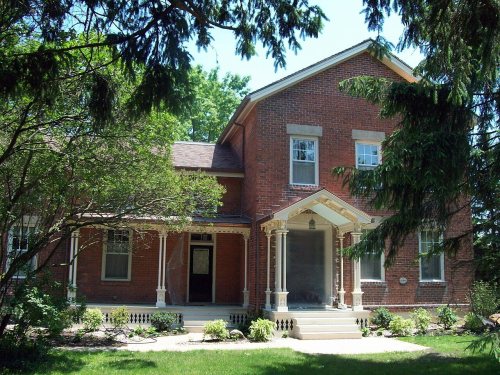
4 places in town are on the National Register, among them the Old Fort Niagara-Colonial Niagara Historic District, a National Historic Landmark, and a historic district with 6 buildings. Below: 1 old photo or paper, maps from 1949 on, and the census since 1820.
Founding year: the first Porter post office (Blevins & Helbock, CC0).The full story ↓
History grade
What drives Porter’s History grade
On its age, its old homes and the National Register, Porter is more historic than 87% of U.S. towns, #312 of 758 in New York. All 3 inputs are above most U.S. towns; its share of homes from before 1940 ranks highest and its National Register listings lowest.
A
HistoryA character grade: shown, never part of Porter’s overall grade.
New York towns list more on the Register than most of the country (a typical New York town has 12.3 per 10,000 residents, the U.S. 2.4), so Porter’s 17.0 sits near the middle of its state (54% of New York towns have fewer) while its 11 historic buildings outnumber those of 76% of U.S. towns.
How sure. Graded on any two of the three inputs instead, the letter would range from A− to A. The pre-1940 share is a Census survey estimate (±5.7 points). The founding year is the first post office, not a stated founding date.
Founding year: the first post office (other dates in Quick answers). Homes: Census ACS 2020–24. National Register: National Park Service, May 2026 list; each listing counted once (boundary changes and added documentation belong to their listing), and a historic district counts its contributing buildings. How TownRatings grades history →
What stands out about Porter’s past
Read from the archive, the National Register and the record. The page puts what stands out first.
Lost post offices, old corners, places now gone and burying grounds
Porter had its own post office from 1831 to 1834.
Youngstown
1815–today
Porter
1831–1834
Ransomville
1833–today
18101920today
Hamlets and corners on the map
BlairvilleCollingwood EstatesFort Niagara BeachHarrison GrovePorter CenterRansomvilleTowers CornersTryonvilleUneeda BeachYoungstownYoungstown EstatesYoungstown Mobile Home Park
Gone or out of use
Dolansky Landing StripairportFort NiagaramilitaryLake Ontario Ordnance WorksmilitaryNike Site NF-03LmilitarySchool Number 10schoolSchool Number 5schoolSchool Number 7schoolSchool Number 8schoolSchool Number 9schoolScott Memorial YMCA Camplocale
8cemeteries and burying grounds inside Porter
Fort NiagaraFort Niagara PostHalstedOaklandRansomville Curtiss PioneerSaint BernardsSaint John Lutheran ChurchTowers
US Post Offices dataset (Blevins & Helbock, CC0). Places and cemeteries from the USGS Geographic Names Information System (2021).
On the National Register
4 historic places in Porter
The country’s official list of buildings and places worth saving. One is a National Historic Landmark, the highest tier.
For thousands of years, the area was inhabited by various cultures of indigenous peoples. At the time of European encounter, this was the territory of the powerful Iroquois Confederacy, based in present-day New York state.
Permanent European-American settlement did not take place until after the American Revolution, about 1801, after most of the Iroquois had been forced to cede their lands to New York and had emigrated across the Niagara River to Upper Canada.
A and B from Michigan and St. Louis; C, G and K from Cincinnati, and D. E and F from North Missouri. Two companies were afterwards joined, but not until after the Porter campaign. Major Clopper's command was stationed at Sturgeon, on the North Missouri Railroad, and when the order was given to take the field against Porter the Fayette detachment was ordered to Clopper, and with four companies strong we took the field. I had just been promoted from sec-
Text read by machine from the scan; it may contain errors.
When we crossed the Chariton, Colonel Porter had some large trees cut so the enemy could not get out with their cannon. He then stationed Captain Jim Porter with one hundred men to give the Federals a gentle surprise — and Jim Porter was the man to do it. Wlien they came to cross, the river was swift and high. They rode right in and were letting their horses drink and were having a good time in the thought that the rebs were gone. Their good
Text read by machine from the scan; it may contain errors.
There was but one Porter living in "Frankfort Town, Hancock Coxmty", in 1790 — or rather but one head of fandly of that name! That was "Robert Porter who, rightly or wrongly, I have assumed was the father of the Robert and Iphraim Porter who liv-
Text read by machine from the scan; it may contain errors.
Scans and text from the Internet Archive. Books published in 1930 or earlier, which are in the public domain.
Timeline
Porter, 1678 to 1960
Woven from the archive, old maps, post office records, the National Register and the people born here.
The Porter post office opened in 1831, the earliest record of the town by name (U.S. post office records).
How does Porter rank for history?
Porter is more historic than 87% of U.S. towns, #312 of 758 in New York. The History grade combines the town’s founding era, the share of homes built before 1940 and its National Register listings. It’s a character grade, so it isn’t part of the overall grade. How it works.
What is on the National Register in Porter?
4 listings: 3 buildings and 1 historic district, the Old Fort Niagara-Colonial Niagara Historic District, with 6 contributing buildings. 11 historic buildings in all.
How old are the homes in Porter?
28% of Porter’s homes were built before 1940 (Census estimate, ±5.7 points), against a typical 27% for a New York town; the median home was built in 1959.
Founding dates: Wikidata, Wikipedia, the U.S. post office records of Blevins & Helbock (CC0) and the Census. Homes by year built: Census ACS 2020–24. National Register of Historic Places: National Park Service (list of May 22, 2026). Old photos, postcards and papers: Wikimedia Commons, the Library of Congress and other public archives, credited on each item’s page. Maps: U.S. Geological Survey historical topographic maps (via Esri) and Sanborn fire-insurance maps (Library of Congress). History text and census tables: Wikipedia (CC BY-SA 4.0). Places that used to be: USGS Geographic Names Information System (2021).
From Wikimedia Commons (5), Wikidata (1), the National Register of Historic Places (4), Wikipedia, Wikidata and Wikipedia for famous people, U.S. Geological Survey historical maps, U.S. Census counts (via Wikipedia), the US Post Offices dataset (Blevins & Helbock), the USGS Geographic Names Information System and old county and town histories (Internet Archive). Archive images are copied here with their credits and licenses, shown on each photo’s page. Refreshed monthly.


 ★ Landmark




 2020
 2018
 2018
 2006


