10 of Fishkill’s places are on the National Register
More historic than 66% of U.S. towns · #553 of 758 in New York. What drives it
Most of Fishkill was built recently: 7% of its homes predate 1940 and the median home dates from 1980. Below: 12 old photos and papers, maps from 1893 on, and the census since 1870.
On its age, its old homes and the National Register, Fishkill is more historic than 66% of U.S. towns, #553 of 758 in New York. Its National Register listings hold the grade up; its share of homes from before 1940 pulls it down.
B+
HistoryA character grade: shown, never part of Fishkill’s overall grade.
New York towns list more on the Register than most of the country (a typical New York town has 12.3 per 10,000 residents, the U.S. 2.4), so Fishkill’s 57.1 sits above most of its state (70% of New York towns have fewer) while its 131 historic buildings outnumber those of 91% of U.S. towns.
How sure. Graded on two of the three inputs, so a change in either one moves the letter more than it would with three. The pre-1940 share (±2.4 points) is firm at this size.
Founding year: our sources. Homes: Census ACS 2020–24. National Register: National Park Service, May 2026 list; each listing counted once (boundary changes and added documentation belong to their listing), and a historic district counts its contributing buildings. How TownRatings grades history →
What stands out about Fishkill’s past
Read from the archive, the National Register and the record. The page puts what stands out first.
Lost post offices, old corners, places now gone and burying grounds
Fishkill’s post office has been open since 1777. Five other post offices opened and closed inside today’s town.
Fishkill
1777–today
Fishkill Landing
1803–1864
Glenham
1839–today
Brinckerhoffville
1872–1891
Dutchess Junction
1876–1934
Brinckerhoff
1891–1932
Brockway
1901–1932
17701900today
Hamlets and corners on the map
Beacon HillsBrinckerhoffBrockwayDutchess JunctionFishkill LandingGlenhamGrovevilleOak Meadows Mobile Home Park
Gone or out of use
Bannerman's Island ArsenalmilitaryDutchess Mall Shopping CenterlocaleFishkill Drive-InlocaleFishkill Supply DepotmilitaryNew York State Hospitalhospital
3cemeteries and burying grounds inside Fishkill
First Reformed Protestant DutchFishkillRombout Rural
US Post Offices dataset (Blevins & Helbock, CC0). Places and cemeteries from the USGS Geographic Names Information System (2021).
On the National Register
10 listings protect 131 historic buildings
The country’s official list of buildings and places worth saving.
Fishkill is located in the former territory of the Wappinger people. It was part of the Rombout Patent granted to Francis Rombouts, Gulian VerPlanck, and Stephanus Van Cortlandt of New Amsterdam in 1685. The name "Fishkill" evolved from two Dutch words, vis (fish) and kil (stream or creek). In 1714, Dutch immigrants settled in the area. The village of Fishkill was a significant crossroads in the overland transportation network in the 18th and 19th centuries. The Queen's Highway, connecting Albany to New York City, intersected with a major overland route from New England to the Hudson River. Among the first to occupy the land now within the village limits were Johannes Ter Boss and Henry Rosecrance.
Passages that mention Fishkill, cut from the printed page as they were published.
The history of Dutchess County, New York1909 · page 770Read the page →
Read the text
Mr. Smith served several years on the Board of Education and as trustee of the village of Fishkill Landing and was president of the village from 1877 to 1882. Prom 1882 to 1886 he represented the town of Fishkill in the Board of Supervisors and was twice elected Chairman of the Board.
Text read by machine from the scan; it may contain errors.
The history of Dutchess County, New York1909 · page 636Read the page →
Read the text
The next pastor of the parish was the Rev. Terence P. Kelly, who was installed on the 1st day of December, 1890. During his pastorate the parish continued to expand and the number of the faithful having so increased in the town of Fishkill that it was decided to establish a new parish. Accordingly on the 26th day of April, 1891, the corner stone of St. John's Church was laid in the Village of Fishkill-on-the-Hudson. The Rev. T. F. Kelly having been transferred to Villa Nova he was succeeded by the Rev. J. H. Briody, who is pas-
Text read by machine from the scan; it may contain errors.
Scans and text from the Internet Archive. Books published in 1930 or earlier, which are in the public domain.
Timeline
Fishkill, 1732 to 1931
Woven from the archive, old maps, post office records, the National Register and the people born here.
Nothing in the archives for these yearsWeddings on Main Street, storms, parades, school pictures, the old store. If it’s in your family album, it belongs here.
Fishkill is more historic than 66% of U.S. towns, #553 of 758 in New York. The History grade combines the town’s founding era, the share of homes built before 1940 and its National Register listings. It’s a character grade, so it isn’t part of the overall grade. How it works.
What is on the National Register in Fishkill?
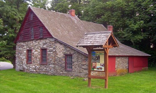
10 listings: 4 buildings, among them the Van Wyck-Wharton House (listed 1972, the first), 3 historic districts, the Fishkill Village District, the Mount Gulian and the Reformed Dutch Church of Fishkill Landing, with 111 contributing buildings, 1 site, and 2 structures. 131 historic buildings in all.
How old are the homes in Fishkill?
7% of Fishkill’s homes were built before 1940 (Census estimate, ±2.4 points), against a typical 27% for a New York town; the median home was built in 1980.
Founding dates: Wikidata, Wikipedia, the U.S. post office records of Blevins & Helbock (CC0) and the Census. Homes by year built: Census ACS 2020–24. National Register of Historic Places: National Park Service (list of May 22, 2026). Old photos, postcards and papers: Wikimedia Commons, the Library of Congress and other public archives, credited on each item’s page. Maps: U.S. Geological Survey historical topographic maps (via Esri) and Sanborn fire-insurance maps (Library of Congress). History text and census tables: Wikipedia (CC BY-SA 4.0). Places that used to be: USGS Geographic Names Information System (2021).
From Wikimedia Commons (10), the Library of Congress (2), the National Register of Historic Places (10), Wikipedia, Wikidata and Wikipedia for famous people, U.S. Geological Survey historical maps, U.S. Census counts (via Wikipedia), the US Post Offices dataset (Blevins & Helbock), the USGS Geographic Names Information System and old county and town histories (Internet Archive). Archive images are copied here with their credits and licenses, shown on each photo’s page. Refreshed monthly.






 1821
 1821
 1825
 1876
 1876
 1907


