Founding year: Wikidata. First post office: 1811.The full story ↓
History grade
What drives Cornwall’s History grade
On its age, its old homes and the National Register, Cornwall is more historic than 97% of U.S. towns, #92 of 758 in New York. All 3 inputs are above most U.S. towns; its age ranks highest and its National Register listings lowest.
A+
HistoryA character grade: shown, never part of Cornwall’s overall grade.
New York towns list more on the Register than most of the country (a typical New York town has 12.3 per 10,000 residents, the U.S. 2.4), so Cornwall’s 53.3 sits above most of its state (69% of New York towns have fewer) while its 68 historic buildings outnumber those of 87% of U.S. towns.
NoteThe founding year comes from Wikidata alone; no second source gives 1685.
How sure. Graded on any two of the three inputs instead, the letter would range from A to A+. The pre-1940 share is a Census survey estimate (±4.6 points).
Founding year: Wikidata (other dates in Quick answers). Homes: Census ACS 2020–24. National Register: National Park Service, May 2026 list; each listing counted once (boundary changes and added documentation belong to their listing), and a historic district counts its contributing buildings. How TownRatings grades history →
What stands out about Cornwall’s past
Read from the archive, the National Register and the record. The page puts what stands out first.
When the explorer Henry Hudson visited the region in 1609, the land was occupied by the Waoraneck Indians. In 1685—which is regarded as the establishment date of Cornwall on local signage—a colony of twenty-five Scottish families settled around the mouth of the Moodna Creek, led by the soldier Major Patrick McGregor and his brother-in-law, David Toiseach, the laird of Monzievaird. In the ensuing 50 years, English and Scottish families came to the fertile tableland above the river meadows naming it "new Cornwall" because of the marked similarity to the County of Cornwall, England, It is believed that the hamlet of Canterbury was the site of this settlement. The first recorded town meeting was held in April 1765, shortly after the Precinct of Cornwall was created in 1764. "New Cornwall" first appears on maps and censi in 1788, after Orange County was subdivided into numerous townships. Th…
Passages that mention Cornwall, cut from the printed page as they were published.
The history of Cornwall, from the earlist records and traditions, to the present time1824 · page 683Read the page →
Read the text
The situation of this last parish in Cornwall, according to our alphabetical arrangement, is in the deanery and west division of the hundred of Penwith. I lies on the north-west coast of Cornwall, about four miles south-south-west from St. Ives, aud about seven north from Penzance. Its principal villages are the church-town, Boswednack, Treen, and Trewy.
Text read by machine from the scan; it may contain errors.
The parochial history of Cornwall, founded on the manuscript histories of Mr. Hals and Mr. Tonkin1838 · page 522Read the page →
Read the text
446 Population of Cornwall, App. II. iv. 178. Of all the parishes in Cornwall from the last pariiamentary statements 177. For several years from 1700 to 1831,178 return for Helston, ii. 161 Porkellia, neighbourhood produced
Text read by machine from the scan; it may contain errors.
The history of Cornwall, from the earlist records and traditions, to the present time1824 · page 702Read the page →
Read the text
I shall close this account of the Seilly Islands by stating, that their importance as a naval station having been pointed out to persons in authority, an order was issued in the ytear 1808, to Mr. Tucker, surveyor-general of the dutchy of Cornwall, to make a report on the subject. This he did most satisfactorily in favour of Seilly, having shewn the disadvantages which attach to every port in the channel to the westward of the Isle of Wight, during the prevalence of certain winds, and the great anperiority which these islands possess as a station for vessels bound to the westward.
Text read by machine from the scan; it may contain errors.
Scans and text from the Internet Archive. Books published in 1930 or earlier, which are in the public domain.
Timeline
Cornwall, 1685 to 1953
Woven from the archive, old maps, post office records, the National Register and the people born here.
Nothing in the archives for these yearsWeddings on Main Street, storms, parades, school pictures, the old store. If it’s in your family album, it belongs here.
Every edition of the U.S. Geological Survey’s map of Cornwall. Tap a year, or press play to watch the town change.
1902Schunemunk sheet · 1:62,500
U.S. Geological Survey historical topographic maps (public domain), via Esri’s collection of the scans. The red ring marks the center of Cornwall.
Every building
Cornwall, building by building, 1887–1905
Fire insurance maps drew every building, what it was made of and what it was used for, so insurers could price the risk of fire. Pick a year, then a sheet.
In 1685, according to Wikidata. Cornwall’s post office opened in 1811, and the first U.S. census counted 4,225 people here in 1790.
How does Cornwall rank for history?
Cornwall is more historic than 97% of U.S. towns, #92 of 758 in New York. The History grade combines the town’s founding era, the share of homes built before 1940 and its National Register listings. It’s a character grade, so it isn’t part of the overall grade. How it works.
What is on the National Register in Cornwall?
36 listings: 33 buildings, among them the Amelia Barr House (listed 1982, the first), and 3 structures. 68 historic buildings in all.
How old are the homes in Cornwall?
29% of Cornwall’s homes were built before 1940 (Census estimate, ±4.6 points), against a typical 27% for a New York town; the median home was built in 1960.
Founding dates: Wikidata, Wikipedia, the U.S. post office records of Blevins & Helbock (CC0) and the Census. Homes by year built: Census ACS 2020–24. National Register of Historic Places: National Park Service (list of May 22, 2026). Old photos, postcards and papers: Wikimedia Commons, the Library of Congress and other public archives, credited on each item’s page. Maps: U.S. Geological Survey historical topographic maps (via Esri) and Sanborn fire-insurance maps (Library of Congress). History text and census tables: Wikipedia (CC BY-SA 4.0). Places that used to be: USGS Geographic Names Information System (2021).
From Wikimedia Commons (20), the Library of Congress (5), Wikidata (5), the National Register of Historic Places (36), Wikipedia, Wikidata and Wikipedia for famous people, U.S. Geological Survey historical maps, U.S. Census counts (via Wikipedia), the US Post Offices dataset (Blevins & Helbock), the USGS Geographic Names Information System, Sanborn fire insurance maps (Library of Congress) and old county and town histories (Internet Archive). Archive images are copied here with their credits and licenses, shown on each photo’s page. Refreshed monthly.


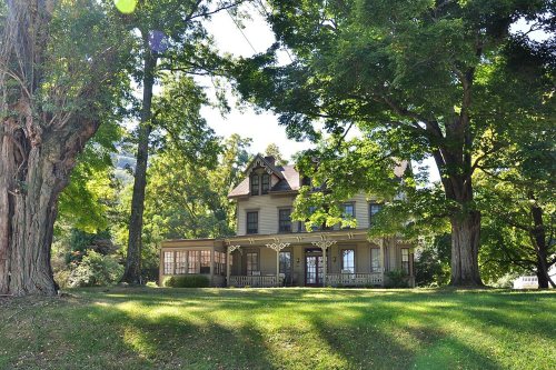


 c. 1880
 1906
 1906
 1906
 1906
 2007
 2007
 2007
 2007
 2007
 2007
 2007
 2007
 2007
 2007
 2007
 2007
 2007
 2006
 2006
 2005


