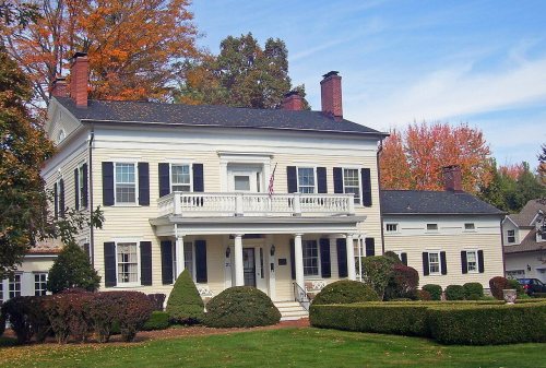
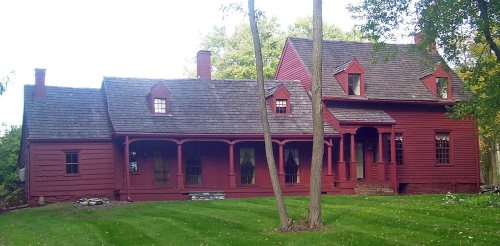
East Fishkill dates to 1849, and 3 of its places are on the National Register
More historic than 55% of U.S. towns · #642 of 758 in New York. What drives it
Most of East Fishkill was built recently: 6% of its homes predate 1940 and the median home dates from 1980. Its Register listings are the Bykenhulle, the Storm-Adriance-Brinckerhoff House and the Hopewell Junction Depot. Below: 11 old photos and papers, maps from 1893 on, and the census since 1850.
On its age, its old homes and the National Register, East Fishkill is more historic than 55% of U.S. towns, #642 of 758 in New York. Its age holds the grade up; its share of homes from before 1940 pulls it down.
B−
HistoryA character grade: shown, never part of East Fishkill’s overall grade.
New York towns list more on the Register than most of the country (a typical New York town has 12.3 per 10,000 residents, the U.S. 2.4), so East Fishkill’s 1.7 sits below most of its state (24% of New York towns have fewer) while its 5 historic buildings outnumber those of 70% of U.S. towns.
How sure. Graded on any two of the three inputs instead, the letter would range from C+ to B. The pre-1940 share (±1.5 points) is firm at this size. Two sources give 1849.
Founding year: Wikipedia (other dates in Quick answers). Homes: Census ACS 2020–24. National Register: National Park Service, May 2026 list; each listing counted once (boundary changes and added documentation belong to their listing), and a historic district counts its contributing buildings. How TownRatings grades history →
What stands out about East Fishkill’s past
Read from the archive, the National Register and the record. The page puts what stands out first.
Lost post offices, old corners, places now gone and burying grounds
East Fishkill had its own post office from 1852 to 1909. Five other post offices opened and closed inside today’s town.
Fishkill Plains
1826–1903
Stormville
1826–today
Shenandoah
1829–1909
Johnsville
1832–1902
Pecksville
1832–1854
East Fishkill
1852–1909
Hopewell Junction
1870–today
Wiccopee
1902–1909
18201920today
Hamlets and corners on the map
Charlotte Grove Mobile CourtFishkill PlainsHillside LakeHopewell JunctionLomalaMoorgate Mobile Home ParkPecksvilleShenandoahStormvilleWiccopee
Gone or out of use
Mid-Hudson Helicopter Service Heliportairport
6cemeteries and burying grounds inside East Fishkill
Ballard - Milltown RoadBethel BaptistMeadSaint DenisVan WyckWiccopee Community Church
US Post Offices dataset (Blevins & Helbock, CC0). Places and cemeteries from the USGS Geographic Names Information System (2021).
On the map
East Fishkill on the map, 1893 to 1981
Every edition of the U.S. Geological Survey’s map of East Fishkill. Tap a year, or press play to watch the town change.
1893Poughkeepsie sheet · 1:62,500
U.S. Geological Survey historical topographic maps (public domain), via Esri’s collection of the scans. The red ring marks the center of East Fishkill.
Timeline
East Fishkill, 1800 to 1991
Woven from the archive, old maps, post office records, the National Register and the people born here.
The Wiccopee, a sub-tribe of the Wappinger Native Americans, once lived in what is now the East Fishkill hamlet of Wiccopee. One early European settler arrived around 1759.
Platt Rogers Spencer, the inventor of the leading U.S. business-handwriting style of the 19th Century, was born in the area in 1800.
The town of East Fishkill was established in 1849 from the eastern part of the town of Fishkill. Its name comes from Fishkill Creek, known as the Vis Kille (Fish Creek) to the Dutch settlers in the area.
Passages that mention East Fishkill, cut from the printed page as they were published.
The history of Dutchess County, New York1909 · page 759Read the page →
Read the text
R. Co. In 1857 Mr. Rapelje purchased a farm in the town of East Fishkill upon which the village of Hopewell Junction was subsequently built. In addition to his agricultural pursuits he became interested in many public enterprises. He was one of the organizers and early directors of the Poughkeepsie Bridge Co., the Dutchess & Columbia R. R. Co., a director of the Dutchess Mutual Insurance Co., etc.
Text read by machine from the scan; it may contain errors.
The history of Dutchess County, New York1909 · page 732Read the page →
Read the text
In 1861 he moved to the town of East Fishkill, and engaged in general mercantile business which he has successfully continued to the present time. Mr. Horton was elected to the office of Supervisor of the town of East Fishkill, 1871-'73, and again in 1880. He has also served several terms as Postmaster.
Text read by machine from the scan; it may contain errors.
Scans and text from the Internet Archive. Books published in 1930 or earlier, which are in the public domain.
By decade
East Fishkill, decade by decade
2 decades in the archive, from the 1870s to the 1940s. Scroll each row; tap a photo for its story.
Nothing in the archives for these yearsWeddings on Main Street, storms, parades, school pictures, the old store. If it’s in your family album, it belongs here.
In 1849, according to Wikipedia’s history of the town. East Fishkill’s post office opened in 1826, and the census of 1850 counted 2,610 people here.
How does East Fishkill rank for history?
East Fishkill is more historic than 55% of U.S. towns, #642 of 758 in New York. The History grade combines the town’s founding era, the share of homes built before 1940 and its National Register listings. It’s a character grade, so it isn’t part of the overall grade. How it works.
What is on the National Register in East Fishkill?
Three places: the Bykenhulle (listed 1991), the Storm-Adriance-Brinckerhoff House (2008) and the Hopewell Junction Depot (2021).
How old are the homes in East Fishkill?
6% of East Fishkill’s homes were built before 1940 (Census estimate, ±1.5 points), against a typical 27% for a New York town; the median home was built in 1980.
Founding dates: Wikidata, Wikipedia, the U.S. post office records of Blevins & Helbock (CC0) and the Census. Homes by year built: Census ACS 2020–24. National Register of Historic Places: National Park Service (list of May 22, 2026). Old photos, postcards and papers: Wikimedia Commons, the Library of Congress and other public archives, credited on each item’s page. Maps: U.S. Geological Survey historical topographic maps (via Esri) and Sanborn fire-insurance maps (Library of Congress). History text and census tables: Wikipedia (CC BY-SA 4.0). Places that used to be: USGS Geographic Names Information System (2021).
From Wikimedia Commons (18), the National Register of Historic Places (3), Wikipedia, Wikidata and Wikipedia for famous people, U.S. Geological Survey historical maps, U.S. Census counts (via Wikipedia), the US Post Offices dataset (Blevins & Helbock), the USGS Geographic Names Information System and old county and town histories (Internet Archive). Archive images are copied here with their credits and licenses, shown on each photo’s page. Refreshed monthly.


 1876
 1946
 1946
 1946
 1946
 1946
 1946
 1946
 1946
 2010
 2010
 2008
 2008
 2008
 2006
 2004