Clarence dates to 1808, and 2 of its places are on the National Register
More historic than 56% of U.S. towns · #635 of 758 in New York. What drives it
Most of Clarence was built recently: 8% of its homes predate 1940 and the median home dates from 1989. Its Register listings are the Eshelman, J., and Company Store and the Automobile Club of Buffalo. Below: 12 old photos and papers, maps from 1905 on, and the census since 1820.
Founding year: Wikidata. First post office: 1810.The full story ↓
History grade
What drives Clarence’s History grade
On its age, its old homes and the National Register, Clarence is more historic than 56% of U.S. towns, #635 of 758 in New York. Its age holds the grade up; its share of homes from before 1940 pulls it down.
B
HistoryA character grade: shown, never part of Clarence’s overall grade.
New York towns list more on the Register than most of the country (a typical New York town has 12.3 per 10,000 residents, the U.S. 2.4), so Clarence’s 0.9 sits below most of its state (22% of New York towns have fewer) while its 3 historic buildings outnumber those of 65% of U.S. towns.
How sure. Graded on any two of the three inputs instead, the letter would range from C+ to B. The pre-1940 share (±1.7 points) is firm at this size. Two sources give 1808.
Founding year: Wikidata (other dates in Quick answers). Homes: Census ACS 2020–24. National Register: National Park Service, May 2026 list; each listing counted once (boundary changes and added documentation belong to their listing), and a historic district counts its contributing buildings. How TownRatings grades history →
What stands out about Clarence’s past
Read from the archive, the National Register and the record. The page puts what stands out first.
Lost post offices, old corners, places now gone and burying grounds
Clarence’s post office has been open since 1810. Four other post offices opened and closed inside today’s town.
Clarence
1810–today
Harris Hill
1842–1902
Clarence Centre
1849–today
East Clarence
1867–1903
Wolcottsburg
1873–1902
Millersport
1874–1902
18101920today
Hamlets and corners on the map
Clarence CenterEast AmherstEast ClarenceHarris HillHunts CornersMillersportRock Oak Estates Mobile Home ParkWolcottsburg
Gone or out of use
School Number 10schoolSchool Number 11schoolSchool Number 12schoolSchool Number 17schoolSchool Number 18schoolSchool Number 5schoolSchool Number 6schoolSchool Number 8school
The local Native Americans called the area Ta-Num-No-Ga-O, which means "Place of Hickory Bark". In modern Seneca, it is known as Tanönogeo’.
Clarence was the first town to be established in Erie County (1808), and many other towns, villages, and cities have been formed from parts of this original town. In 1810, the town of Buffalo, from which the city of Buffalo later originated, was separated from Clarence. Then in 1823, Newstead and Alden were formed respectively from the east and southeast parts of Clarence. Then finally in 1833, Lancaster was also formed from the town. The defunct town of Willink was also a source of new towns, primarily in the south part of the county, being completely partitioned for this purpose.
Passages that mention Clarence, cut from the printed page as they were published.
History of the original town of Concord1883 · page 403Read the page →
Read the text
in the battles of Bunker Hill and Saratoga. He drew a soldier's right for land of the Government, located it in Cayuga county and settled on the same. His father was a physician and settled in the town of Clarence, afterward Newstead, in 1816, and here Lorenzo spent his boyhood days and received his education. When he lived in Clarence he lived in the same neighborhood and was acquainted with Asa Ransom, Sr., Archibald S. Clark, Peter Vandeventer, Col. James Cronk, Elias
Text read by machine from the scan; it may contain errors.
History of the original town of Concord1883 · page 563Read the page →
Read the text
Peter Pratt and family, who were pioneers of Clarence, having come from Taunton, Mass., in 1806, to that town, were the next settlers, and I cheerfully allow m)- venerable friend, John Pratt, of Bagdad, to tell his story: " In the F'all of 1810, my father and brother, Luther, came out from Clarence and built a log house on the Derby lot (this is now part of the Emer\' Bond farm in Concord), and the next PY'bruary following, he moved his family out by way of Boston and over
Text read by machine from the scan; it may contain errors.
Scans and text from the Internet Archive. Books published in 1930 or earlier, which are in the public domain.
Timeline
Clarence, 1808 to 2020
Woven from the archive, old maps, post office records, the National Register and the people born here.
Nothing in the archives for these yearsWeddings on Main Street, storms, parades, school pictures, the old store. If it’s in your family album, it belongs here.
Nothing in the archives for these yearsWeddings on Main Street, storms, parades, school pictures, the old store. If it’s in your family album, it belongs here.
In 1808, according to Wikidata. Clarence’s post office opened in 1810, and the census of 1820 counted 3,278 people here.
How does Clarence rank for history?
Clarence is more historic than 56% of U.S. towns, #635 of 758 in New York. The History grade combines the town’s founding era, the share of homes built before 1940 and its National Register listings. It’s a character grade, so it isn’t part of the overall grade. How it works.
What is on the National Register in Clarence?
Two places: the Eshelman, J., and Company Store (listed 1982) and the Automobile Club of Buffalo (2012).
How old are the homes in Clarence?
8% of Clarence’s homes were built before 1940 (Census estimate, ±1.7 points), against a typical 27% for a New York town; the median home was built in 1989.
Founding dates: Wikidata, Wikipedia, the U.S. post office records of Blevins & Helbock (CC0) and the Census. Homes by year built: Census ACS 2020–24. National Register of Historic Places: National Park Service (list of May 22, 2026). Old photos, postcards and papers: Wikimedia Commons, the Library of Congress and other public archives, credited on each item’s page. Maps: U.S. Geological Survey historical topographic maps (via Esri) and Sanborn fire-insurance maps (Library of Congress). History text and census tables: Wikipedia (CC BY-SA 4.0). Places that used to be: USGS Geographic Names Information System (2021).
From Wikimedia Commons (24), the National Register of Historic Places (2), Wikipedia, Wikidata and Wikipedia for famous people, U.S. Geological Survey historical maps, U.S. Census counts (via Wikipedia), the US Post Offices dataset (Blevins & Helbock), the USGS Geographic Names Information System and old county and town histories (Internet Archive). Archive images are copied here with their credits and licenses, shown on each photo’s page. Refreshed monthly.


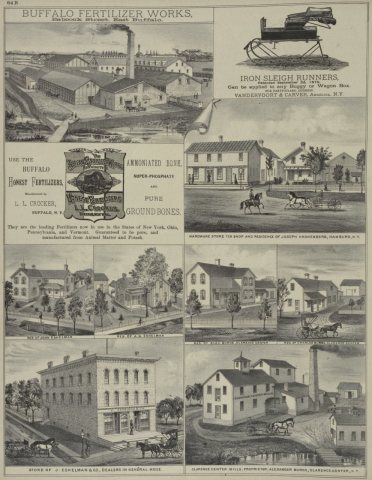


 1866
 1880
 1880
 1880
 1880
 1880
 1986
 1988
 1989
 2015
 2013
 2012
 2012
 2012
 2010
 2010
 2010
 2010
 2010
 2010
 2006


