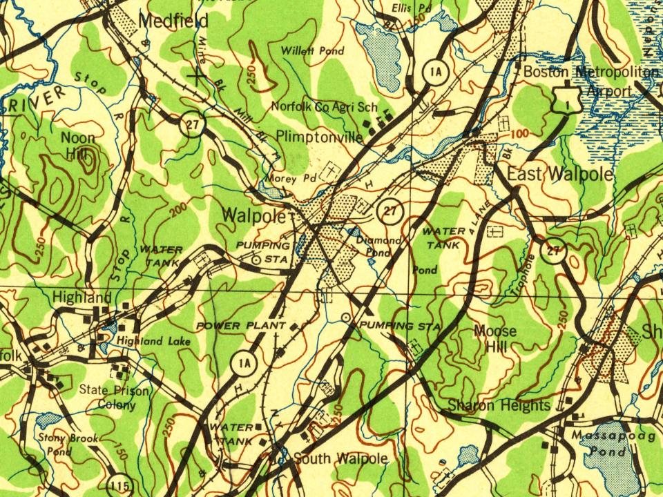
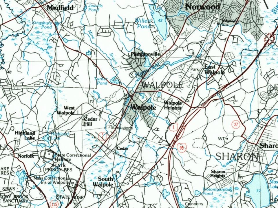
Walpole dates to 1659, and 13% of its homes were built before 1940
More historic than 72% of U.S. towns · #250 of 283 in Massachusetts. What drives it
Its Register listings are the Deacon Willard Lewis House, the Walpole Town Hall and the Union Station. Below: 6 old photos and papers, maps from 1894 on, and the census since 1790.
Founding year: Wikidata; Wikipedia’s history section gives the same year. First post office: 1820.The full story ↓
History grade
What drives Walpole’s History grade
On its age, its old homes and the National Register, Walpole is more historic than 72% of U.S. towns, #250 of 283 in Massachusetts. Its age holds the grade up; its National Register listings pull it down.
B+
HistoryA character grade: shown, never part of Walpole’s overall grade.
Massachusetts towns list more on the Register than most of the country (a typical Massachusetts town has 46.0 per 10,000 residents, the U.S. 2.4), so Walpole’s 1.1 sits below most of its state (10% of Massachusetts towns have fewer) while its 3 listings outnumber those of 65% of U.S. towns.
How sure. Graded on any two of the three inputs instead, the letter would range from C+ to A−. The pre-1940 share (±2.8 points) is firm at this size. Two sources give 1659.
Founding year: Wikidata (other dates in Quick answers). Homes: Census ACS 2020–24. National Register: National Park Service, May 2026 list; each listing counted once (boundary changes and added documentation belong to their listing), and a historic district counts its contributing buildings. How TownRatings grades history →
What stands out about Walpole’s past
Read from the archive, the National Register and the record. The page puts what stands out first.
US Post Offices dataset (Blevins & Helbock, CC0). Places and cemeteries from the USGS Geographic Names Information System (2021).
Every building
Walpole, building by building, 1894–1927
Fire insurance maps drew every building, what it was made of and what it was used for, so insurers could price the risk of fire. Pick a year, then a sheet.
It started out as a territory that was claimed by the Neponset band of the Massachusett Native American tribe. The Neponset tribe officially claimed the area that is now Walpole, and some of its surrounding territory, in 1635. The town of Dedham was not included in this claim, so they began to negotiate with the Neponset tribe to gain land. In 1636, a deal was made between the town of Dedham and the Neponsets to grant Dedham lands that now comprise the towns of Walpole, Norwood, Westwood, Medfield, Norfolk and Dover as well as Dedham. The land given to Dedham in this deal currently includes parts of 16 different towns.
Passages that mention Walpole, cut from the printed page as they were published.
History of Norfolk County, Massachusetts, 1622-19181918Read the page →
Read the text
EARLY HISTORY When the Town of Dedham was incorporated in 1636 it included the territory now comprising the Town of Walpole, and for nearly a century the history of Walpole is part of the history of Dedham. There is abundant evidence that settlements were made within the limits of Walpole at an early date. The cedar swamp frequently mentioned in the early Dedham records is generally conceded to be the cedar swamp "lying between the plain and South Walpole." In May, 1658, Eleazer Lusher and Joshua Fisher were granted a privilege to erect a saw
Text read by machine from the scan; it may contain errors.
Meeting House and Minister rT'*HOUGH at the setting off of Walpole the theocratic government founded by the Puritans no longer flourished in its pristine strength, minister and meeting house still re¬ mained the centres around which the life of the community revolved. Perhaps no more conclusive evidence of this can be offered than
Text read by machine from the scan; it may contain errors.
Just how many of the French Neutrals were now left in Walpole is not clear and the press of time does not allow of a study of the problem. From somewhere two additional Dantromonts appeared on the scene; so that when a reap¬ portionment of the Acadians was made in the summer of 1760 we find Margaret, Paul and Benoni “Dautromont” left in Walpole, and
Text read by machine from the scan; it may contain errors.
History of Norfolk County, Massachusetts, 1622-19181918Read the page →
Read the text
Walpole has a bank, a weekly newspaper (the Enterprise), a fine public library, six public school buildings, parks and playgrounds, well kept streets, a number of manufacturing establishments with an invested capital of over five millions of dollars, electric light, telephone connections with the surrounding towns and the City of Boston, three postoffices — Walpole, East Walpole and South Walpole — and a number of well tilled farms. Two lines of the New York, New Haven & Hartford railway system pass through the town, crossing each other at Walpole Junction, and there are electric lines to the adjoining towns. Evidence of pros-
Text read by machine from the scan; it may contain errors.
Scans and text from the Internet Archive. Books published in 1930 or earlier, which are in the public domain.
By decade
Walpole, decade by decade
4 decades in the archive, from the 1870s to the 1940s. Scroll each row; tap a photo for its story.
Nothing in the archives for these yearsWeddings on Main Street, storms, parades, school pictures, the old store. If it’s in your family album, it belongs here.
In 1659, according to Wikidata and Wikipedia’s history of the town. Walpole’s post office opened in 1820, and the first U.S. census counted 1,005 people here in 1790.
How does Walpole rank for history?
Walpole is more historic than 72% of U.S. towns, #250 of 283 in Massachusetts. The History grade combines the town’s founding era, the share of homes built before 1940 and its National Register listings. It’s a character grade, so it isn’t part of the overall grade. How it works.
What is on the National Register in Walpole?
Three places: the Deacon Willard Lewis House (listed 1975), the Walpole Town Hall (1981) and the Union Station (2016).
How old are the homes in Walpole?
13% of Walpole’s homes were built before 1940 (Census estimate, ±2.8 points), against a typical 21% for a Massachusetts town; the median home was built in 1977.
Founding dates: Wikidata, Wikipedia, the U.S. post office records of Blevins & Helbock (CC0) and the Census. Homes by year built: Census ACS 2020–24. National Register of Historic Places: National Park Service (list of May 22, 2026). Old photos, postcards and papers: Wikimedia Commons, the Library of Congress and other public archives, credited on each item’s page. Maps: U.S. Geological Survey historical topographic maps (via Esri) and Sanborn fire-insurance maps (Library of Congress). History text and census tables: Wikipedia (CC BY-SA 4.0). Places that used to be: USGS Geographic Names Information System (2021).
From Wikimedia Commons (12), the National Register of Historic Places (3), Wikipedia, Wikidata and Wikipedia for famous people, U.S. Geological Survey historical maps, U.S. Census counts (via Wikipedia), the US Post Offices dataset (Blevins & Helbock), the USGS Geographic Names Information System, Sanborn fire insurance maps (Library of Congress) and old county and town histories (Internet Archive). Archive images are copied here with their credits and licenses, shown on each photo’s page. Refreshed monthly.




 1876
 1888
 2010
 2009
 2008
 2008
 2008
 2006