Dover’s post office opened in 1828, and 10% of its homes were built before 1940
More historic than 66% of U.S. towns · #260 of 283 in Massachusetts. What drives it
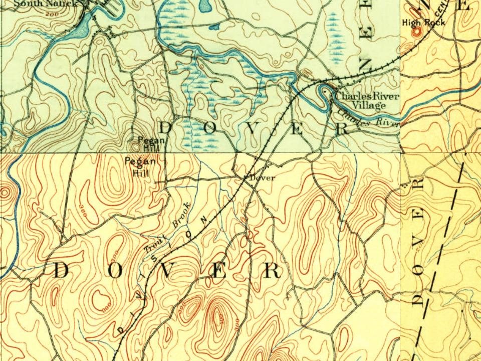
2 places in town are on the National Register, among them a historic district with 7 buildings. Below: 2 old photos and papers, maps from 1889 on, and the census since 1790.
Founding year: the first Dover post office (Blevins & Helbock, CC0).The full story ↓
History grade
What drives Dover’s History grade
On its age, its old homes and the National Register, Dover is more historic than 66% of U.S. towns, #260 of 283 in Massachusetts. Its age holds the grade up; its share of homes from before 1940 pulls it down.
B+
HistoryA character grade: shown, never part of Dover’s overall grade.
Massachusetts towns list more on the Register than most of the country (a typical Massachusetts town has 46.0 per 10,000 residents, the U.S. 2.4), so Dover’s 15.2 sits below most of its state (33% of Massachusetts towns have fewer) while its 9 historic buildings outnumber those of 75% of U.S. towns.
How sure. Graded on any two of the three inputs instead, the letter would range from B− to B+. The pre-1940 share is a Census survey estimate (±3.5 points). The founding year is the first post office, not a stated founding date.
Founding year: the first post office (other dates in Quick answers). Homes: Census ACS 2020–24. National Register: National Park Service, May 2026 list; each listing counted once (boundary changes and added documentation belong to their listing), and a historic district counts its contributing buildings. How TownRatings grades history →
What stands out about Dover’s past
Read from the archive, the National Register and the record. The page puts what stands out first.
The first recorded settlement of Dover was in 1640. It was later established as the Springfield Parish of Dedham in 1748, and incorporated as District Dedham in 1784. Dover was officially incorporated as a town in 1836.
The Benjamin Caryl House, at 107 Dedham St., dates from about 1777 and was the home of Dover's first minister, Benjamin Caryl, his son George, who was the town's first doctor, and their descendants until 1897. It has been owned by the town and operated by the Historical Society since 1920. The house retains its architectural integrity and has been carefully restored to reflect life in the 1790s when the first two Caryl families lived and worked there together.
azure on a mount vert a meeting-house, without steeple, proper ; crest, a plough and garb, crosswise, proper ; motto, "Incorporated 1836," surrounded by a circle inscribed in chief "Town of Dover," and in base "Massachusetts," divided on the dexter side by "Parish 1748 " and the sinister side by " District 1784."
Text read by machine from the scan; it may contain errors.
Be it therefore enacted by the Senate and House of Representatives in the General Court assembled, and by the authority of the same, that the said Fourth Precinct in Dedham be and it hereby is incorporated into a district by the name of Dover, with all the powers, privileges, and immunities of incorporated districts [the bounds having been given in a previous chapter are here omitted], provided that the freeholders and inhabitants of the said district of Dover shall pay their proportion of all taxes
Text read by machine from the scan; it may contain errors.
The genealogical history of Dover, Massachusetts1917 · page 88Read the page →
Read the text
is unknown. He was admitted a freeman in Dedham January I, 1645. The bridge across Charles river in the east part of the town was named for this family. All of the Day settlements in Dover were made on the river and extend from the bridge west as far as the farm of Frederic H. Curtiss. Children: Elizabeth, b. Jan. 27, 1710; m. Jan. i, 1732, John Herring, Wallingford. Conn.
Text read by machine from the scan; it may contain errors.
The genealogical history of Dover, Massachusetts1917 · page 88Read the page →
Read the text
is unknown. He was admitted a freeman in Dedham January I, 1645. The bridge across Charles river in the east part of the town was named for this family. All of the Day settlements in Dover were made on the river and extend from the bridge west as far as the farm of Frederic H. Curtiss. Children : Elizabeth, b. Jan. 27, 1710; m. Jan. i, 1732, John Herring, Wal- Hngford, Conn.
Text read by machine from the scan; it may contain errors.
Scans and text from the Internet Archive. Books published in 1930 or earlier, which are in the public domain.
By decade
Dover, decade by decade
2 decades in the archive, from the 1890s to the 1940s. Scroll each row; tap a photo for its story.
Nothing in the archives for these yearsWeddings on Main Street, storms, parades, school pictures, the old store. If it’s in your family album, it belongs here.
Nothing in the archives for these yearsWeddings on Main Street, storms, parades, school pictures, the old store. If it’s in your family album, it belongs here.
The Dover post office opened in 1828, the earliest record of the town by name (U.S. post office records).
How does Dover rank for history?
Dover is more historic than 66% of U.S. towns, #260 of 283 in Massachusetts. The History grade combines the town’s founding era, the share of homes built before 1940 and its National Register listings. It’s a character grade, so it isn’t part of the overall grade. How it works.
What is on the National Register in Dover?
Two places: the Elm Bank (listed 1987) and the Benjamin Caryl House (2000).
How old are the homes in Dover?
10% of Dover’s homes were built before 1940 (Census estimate, ±3.5 points), against a typical 21% for a Massachusetts town; the median home was built in 1970.
Founding dates: Wikidata, Wikipedia, the U.S. post office records of Blevins & Helbock (CC0) and the Census. Homes by year built: Census ACS 2020–24. National Register of Historic Places: National Park Service (list of May 22, 2026). Old photos, postcards and papers: Wikimedia Commons, the Library of Congress and other public archives, credited on each item’s page. Maps: U.S. Geological Survey historical topographic maps (via Esri) and Sanborn fire-insurance maps (Library of Congress). History text and census tables: Wikipedia (CC BY-SA 4.0). Places that used to be: USGS Geographic Names Information System (2021).
From Wikimedia Commons (6), the National Register of Historic Places (2), Wikipedia, U.S. Geological Survey historical maps, U.S. Census counts (via Wikipedia), the US Post Offices dataset (Blevins & Helbock), the USGS Geographic Names Information System and old county and town histories (Internet Archive). Archive images are copied here with their credits and licenses, shown on each photo’s page. Refreshed monthly.





 2013
 2011
 2010
 2010