Guest, Sign inJoin

Post to Hazel Green

We’ll email a one-tap link to publish your post. No password, and nothing is public until you click it.
Already a member? Sign in
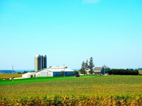
Hazel Green Municipal Hall - panoramioPhoto: Corey Coyle · CC BY 3.0
–Not graded
History · Hazel Green

26% of Hazel Green’s homes were built before 1940

Below: 3 old photos and papers, maps from 1952 on, and the census since 1870.

0on the National Register
26%homes built before 1940
3old photos & papers
4famous people
From Hazel Green’s archive · credits on each photo

What stands out about Hazel Green’s past

Read from the archive, the National Register and the record. The page puts what stands out first.

★ What stands out · Help out

Start Hazel Green’s collection

The first neighbors to add old photos shape how Hazel Green’s history is told.

Decades since 1900 with photos
00s10s20s30s40s50s60s70s80s90s
1 of 10 decades. The empty ones are waiting for someone’s album.
People over time

Hazel Green, census by census

02004006008001,0001,2001,40018801900192019401960198020002020723 in 1870Low: 426

Lost a third of its people between 1870 and 1890, then more than doubled.

16 censuses, 1870–2020.

U.S. Census Bureau decennial counts, from the census table on Hazel Green’s Wikipedia page.

The story

How Hazel Green came to be

From Wikipedia’s history of Hazel Green.

Read it all →

In 1825, the village was named from dense growth of American Hazelnut near the town site.

In 1876, a tornado struck Hazel Green; nine died, many were injured, and property loss was approximately $40,000 to $50,000 (equivalent to $1.21 million to $1.51 million in 2025).

Text from Wikipedia, licensed CC BY-SA 4.0.

From the old history books

What they wrote about Hazel Green, 1881–1900

Passages that mention Hazel Green, cut from the printed page as they were published.

dences which were erected in Rood's Addition went up about this time, and Lewisburg, a town of great ambition, but slender prospects, was beginning to come into notice. This projected municipality was surveyed and platted in 1846 by Henry C. Wiltse, on the Curtis farm, a mile north of Hazel Green, …
[History of Grant County, Wisconsin, preceded by a history of Wisconsin1881 · page 738Read the page →
Read the text

dences which were erected in Rood's Addition went up about this time, and Lewisburg, a town of great ambition, but slender prospects, was beginning to come into notice. This projected municipality was surveyed and platted in 1846 by Henry C. Wiltse, on the Curtis farm, a mile north of Hazel Green, and named after Lewis Curtis, who will be remembered as an arrival here in 1827. It was thought that the enterprise might, in time, either neutralize the influence and importance of Hazel Green, or become a valuable addition to that place. Lots were laid out, streets designated and named, and other improvements proposed, but they were never realized, nor were the ambitions of its founders ; the village that was to be failed to attract visitors ;

Text read by machine from the scan; it may contain errors.
The following diggings are in the village of Hazel Green, but not on the lands of the Hazel Green Mining Company : McBrien & Co. — This is an east-and-west sheet, connected with a quartering one averaging about an inch thick, situated on the land of Dr. McBrien, on the northwest quarter of Section …
History of Grant County Wisconsin1900 · page 234Read the page →
Read the text

The following diggings are in the village of Hazel Green, but not on the lands of the Hazel Green Mining Company : McBrien & Co. — This is an east-and-west sheet, connected with a quartering one averaging about an inch thick, situated on the land of Dr. McBrien, on the northwest quarter of Section 25, Town 1, Range 1 west. The range was worked in 1844, and the ore taken out to the water-level. The water having become much reduced by the Hazel Green Company’s level, work was recommenced in 1871, since which

Text read by machine from the scan; it may contain errors.
St. Joseph’s Church , Sinsinawa Mound. — This parish, in the town of Hazel Green, is situated at “the Mound,” four miles west erf the vil¬ lage. From 1837 until 1842 Rev. Father Samuel Mazzuchelli said mass in the houses of anumber of the settlers about the Mound. In the latter year a log church wa…
History of Grant County Wisconsin1900 · page 557Read the page →
Read the text

St. Joseph’s Church , Sinsinawa Mound. — This parish, in the town of Hazel Green, is situated at “the Mound,” four miles west erf the vil¬ lage. From 1837 until 1842 Rev. Father Samuel Mazzuchelli said mass in the houses of anumber of the settlers about the Mound. In the latter year a log church was built on the land of Kieran Murray, half a mile south of the Mound. In 1845 this building was moved to the Mound. In 1882 the present St. Joseph’s church was built threequarters of a mile east of the Mound. The pastors of the church have

Text read by machine from the scan; it may contain errors.

Scans and text from the Internet Archive. Books published in 1930 or earlier, which are in the public domain.

Timeline

Hazel Green, 1839 to 1980

Woven from the archive, old maps, post office records, the National Register and the people born here.

  1. 19th century
  2. 1839Post officeThe Sinsinawa Mound post office opens
  3. 1851Born hereHenry Olerich is born here
  4. 1872Born hereLeroy D. Eastman is born here
  5. 1883Post officeThe Sinsinawa Mound post office closes
  6. 1883Post officeThe Sinsinawa post office opens
  7. 20th century
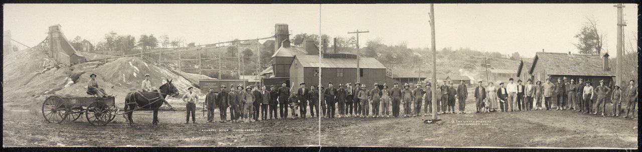
  8. 1915In the archiveCleveland Mine, Hazel Green, Wis
  9. 1935Born hereBurton A. Scott is born here
  10. 1947Born hereJohn W. Cox, Jr. is born here
  11. 1952On the mapFirst mapped by the U.S. Geological Survey
  12. 1980CensusPopulation peaks at 1,282
By decade

Hazel Green, decade by decade

One decade in the archive so far: the 1910s. Scroll each row; tap a photo for its story.

On the map

Hazel Green on the map in 1952

The U.S. Geological Survey’s map of Hazel Green.

Hazel Green on the 1952 USGS map1952Cuba City sheet · 1:24,000

U.S. Geological Survey historical topographic maps (public domain), via Esri’s collection of the scans. The red ring marks the center of Hazel Green.

Then & now

Stand where they stood

No then-and-now pairs yet. Take a photo from the same spot as an old one and they appear here side by side.

Cleveland Mine, Hazel Green, Wis
Retake this viewCleveland Mine, Hazel Green, Wis, 1915

Find the spot, match the angle, and add your photo. It becomes the first then-and-now pair on Hazel Green’s page.

Retake this view · +15
Famous people

4 famous people were born in Hazel Green

Writers, athletes, leaders and more, ranked by how widely they’re known.

See all →
Places that used to be

Lost post offices, old corners and burying grounds

Another post office, Sinsinawa Mound, opened and closed inside today’s town.

Sinsinawa Mound
1839–1883
Sinsinawa
1883–today
18301930today
Hamlets and corners on the map
Prairie CornersSinsinawa
2cemeteries and burying grounds inside Hazel Green
Saint DominicSaint Joseph

US Post Offices dataset (Blevins & Helbock, CC0). Places and cemeteries from the USGS Geographic Names Information System (2021).

Stories next door

History across the town line

Each neighbor’s History grade, on the same three inputs.

Questions about Hazel Green’s history

Memory lane

What the archives can’t tell you, neighbors can.

Town Square →
Start a conversation
Sources

Where this page comes from

Founding dates: Wikidata, Wikipedia, the U.S. post office records of Blevins & Helbock (CC0) and the Census. Homes by year built: Census ACS 2020–24. National Register of Historic Places: National Park Service (list of May 22, 2026). Old photos, postcards and papers: Wikimedia Commons, the Library of Congress and other public archives, credited on each item’s page. Maps: U.S. Geological Survey historical topographic maps (via Esri) and Sanborn fire-insurance maps (Library of Congress). History text and census tables: Wikipedia (CC BY-SA 4.0). Places that used to be: USGS Geographic Names Information System (2021). How TownRatings grades history →

From Wikimedia Commons (9), the Library of Congress (2), Wikidata (1), Wikipedia, Wikidata and Wikipedia for famous people, U.S. Geological Survey historical maps, U.S. Census counts (via Wikipedia), the US Post Offices dataset (Blevins & Helbock), the USGS Geographic Names Information System and old county and town histories (Internet Archive). Archive images are copied here with their credits and licenses, shown on each photo’s page. Refreshed monthly.