Troy dates to 1787, and 55% of its homes were built before 1940
More historic than 98% of U.S. towns · #43 of 758 in New York. What drives it
66 places in town are on the National Register, among them 4 National Historic Landmarks and ten historic districts with 1,512 buildings between them. Below: 6 old photos and papers, maps from 1885 on, and the census since 1820.
Founding year: Wikidata. First post office: 1792.The full story ↓
History grade
What drives Troy’s History grade
On its age, its old homes and the National Register, Troy is more historic than 98% of U.S. towns, #43 of 758 in New York. All 3 inputs are above most U.S. towns; its share of homes from before 1940 ranks highest and its age lowest.
A+
HistoryA character grade: shown, never part of Troy’s overall grade.
New York towns list more on the Register than most of the country (a typical New York town has 12.3 per 10,000 residents, the U.S. 2.4), so Troy’s 315 sits above most of its state (87% of New York towns have fewer) while its 1,605 historic buildings outnumber those of 99% of U.S. towns.
NoteThe founding year comes from Wikidata alone; no second source gives 1787.
How sure. Graded on any two of the three inputs instead, the letter would range from A to A+. The pre-1940 share (±2.2 points) is firm at this size.
Founding year: Wikidata (other dates in Quick answers). Homes: Census ACS 2020–24. National Register: National Park Service, May 2026 list; each listing counted once (boundary changes and added documentation belong to their listing), and a historic district counts its contributing buildings. How TownRatings grades history →
What stands out about Troy’s past
Read from the archive, the National Register and the record. The page puts what stands out first.
The country’s official list of buildings and places worth saving. 4 are National Historic Landmarks, the highest tier. Boundary changes and added documentation are counted with their listing.
Prior to the arrival of Europeans, the Mohican Indians had a number of settlements along the Hudson River near its confluence with the Mohawk River. The land comprising the Poesten Kill and Wynants Kill areas—"kill" being the Dutch word for "creek" or small stream—were owned by two Mohican groups. The land around the Poesten Kill was owned by Skiwias and was called Panhooseck. The area around the Wynants Kill, known as Paanpack, was owned by Peyhaunet. The land between the creeks, which makes up most of today's downtown and South Troy neighborhood along the Hudson River, was owned by Annape. South of the Wynants Kill and into present-day Town of North Greenbush, the land was owned by Pachquolapiet. These parcels of land were sold to the Dutch between 1630 and 1657, and each purchase was overseen and signed by Skiwias, the sachem—the political leader of the Indigenous people—at the time.…
Passages that mention Troy, cut from the printed page as they were published.
Troy and Paeonia, with glimpses of ancient Balkan history and religion1925 · page 50Read the page →
Read the text
6 Homerische Poetik, I. p. 210. Drerup assumes that songs of Troy were composed by wandering singers, who were entertained at the “Mycenaean” court of Troy or had fought together with their compatriots before the walls of Troy.
Text read by machine from the scan; it may contain errors.
Troy and Paeonia, with glimpses of ancient Balkan history and religion1925 · page 19Read the page →
Read the text
Why and how did the Lykians from the Xanthus come to Troy? It is easy to see why the Danubian allies, the Paeonians, came from two hundred miles away along the old highway of trading that led from Serbia to Troy.
Text read by machine from the scan; it may contain errors.
The astonishing history of Troy town1913 · page 247Read the page →
Read the text
If we take the town of Troy as a base, lying north and south, this sign-post forms the apex of a triangle which has two high-roads for its remaining sides — the one road entering Troy from the north by the hill which Sam had just ascended, the other running south-
Text read by machine from the scan; it may contain errors.
Scans and text from the Internet Archive. Books published in 1930 or earlier, which are in the public domain.
Timeline
Troy, 1787 to 1989
Woven from the archive, old maps, post office records, the National Register and the people born here.
Fire insurance maps drew every building, what it was made of and what it was used for, so insurers could price the risk of fire. Pick a year, then a sheet.
Lost post offices, old corners, places now gone and burying grounds
Troy’s post office has been open since 1795. Another post office, Lansingburg, opened and closed inside today’s town.
Lansingburg
1792–1882
Troy
1795–today
17901910today
Hamlets and corners on the map
Frear ParkHudson River Mobile Home ParkLansingburghPine View EstatesSouth Troy
Gone or out of use
American TheatrebuildingImmaculate Conception MonasteryschoolLansingburgh High SchoolschoolLeonard HospitalhospitalLeonard HospitalhospitalMarshall HospitalhospitalMemorial United Methodist ChurchchurchOxford TheatrebuildingPalace TheatrebuildingPowers Public SchoolschoolProctor's TheatrebuildingPublic School Number 10schoolPublic School Number 14schoolPublic School Number 2schoolPublic School Number 5schoolSaint Lawrence Ruthenian Catholic ChurchchurchState TheatrebuildingTrinity Methodist Episcopal Churchchurch
10cemeteries and burying grounds inside Troy
Elmwood HillNew Mount IdaOakwoodOld Mount IdaSaint JohnSaint JosephSaint MarysSaint NicholasSaint PetersTemple Beth El
US Post Offices dataset (Blevins & Helbock, CC0). Places and cemeteries from the USGS Geographic Names Information System (2021).
Help out
Finish Troy’s story
Most archives stop around 1920. The photos from after that are in family albums, not libraries.
Decades since 1900 with photos
00s10s20s30s40s50s60s70s80s90s
0 of 10 decades. The empty ones are waiting for someone’s album.
In 1787, according to Wikidata. Troy’s post office opened in 1792, and the census of 1820 counted 5,264 people here.
How does Troy rank for history?
Troy is more historic than 98% of U.S. towns, #43 of 758 in New York. The History grade combines the town’s founding era, the share of homes built before 1940 and its National Register listings. It’s a character grade, so it isn’t part of the overall grade. How it works.
What is on the National Register in Troy?
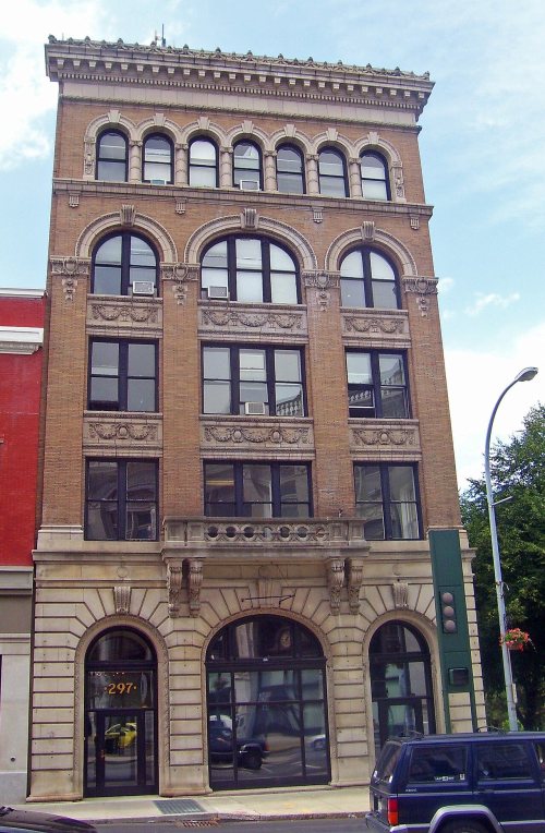
66 listings, 4 of them National Historic Landmarks: 53 buildings, among them the W. & L. E. Gurley Building (a National Historic Landmark since 1970), 11 historic districts with 1,512 contributing buildings, and 2 sites. 1,605 historic buildings in all.
How old are the homes in Troy?
55% of Troy’s homes were built before 1940 (Census estimate, ±2.2 points), against a typical 27% for a New York town; the median home was built in 1938.
Founding dates: Wikidata, Wikipedia, the U.S. post office records of Blevins & Helbock (CC0) and the Census. Homes by year built: Census ACS 2020–24. National Register of Historic Places: National Park Service (list of May 22, 2026). Old photos, postcards and papers: Wikimedia Commons, the Library of Congress and other public archives, credited on each item’s page. Maps: U.S. Geological Survey historical topographic maps (via Esri) and Sanborn fire-insurance maps (Library of Congress). History text and census tables: Wikipedia (CC BY-SA 4.0). Places that used to be: USGS Geographic Names Information System (2021).
From Wikimedia Commons (4), the Library of Congress (2), the National Register of Historic Places (66), Wikipedia, Wikidata and Wikipedia for famous people, U.S. Geological Survey historical maps, U.S. Census counts (via Wikipedia), the US Post Offices dataset (Blevins & Helbock), the USGS Geographic Names Information System, Sanborn fire insurance maps (Library of Congress) and old county and town histories (Internet Archive). Archive images are copied here with their credits and licenses, shown on each photo’s page. Refreshed monthly.


 ★ Landmark
 ★ Landmark
 ★ Landmark
 ★ Landmark






 1808
 1820
 1820
 1821


