Oyster Bay dates to 1667, and 61 of its places are on the National Register
More historic than 81% of U.S. towns · #410 of 758 in New York. What drives it
Most of Oyster Bay was built recently: 10% of its homes predate 1940 and the median home dates from 1957. 61 places in town are on the National Register, among them four historic districts with 52 buildings between them. Below: 16 old photos and papers, maps from 1891 on, and the census since 1790.
Founding year: Wikidata. First post office: 1802.The full story ↓
History grade
What drives Oyster Bay’s History grade
On its age, its old homes and the National Register, Oyster Bay is more historic than 81% of U.S. towns, #410 of 758 in New York. Its age holds the grade up; its share of homes from before 1940 pulls it down.
A−
HistoryA character grade: shown, never part of Oyster Bay’s overall grade.
Among the 400 U.S. cities of 100,000 or more, Oyster Bay ranks #118 on History.
New York towns list more on the Register than most of the country (a typical New York town has 12.3 per 10,000 residents, the U.S. 2.4), so Oyster Bay’s 6.2 sits near the middle of its state (38% of New York towns have fewer) while its 186 historic buildings outnumber those of 93% of U.S. towns.
NoteThe founding year comes from Wikidata alone; no second source gives 1667.
How sure. Graded on any two of the three inputs instead, the letter would range from B to A. The pre-1940 share (±0.7 points) is firm at this size.
Founding year: Wikidata (other dates in Quick answers). Homes: Census ACS 2020–24. National Register: National Park Service, May 2026 list; each listing counted once (boundary changes and added documentation belong to their listing), and a historic district counts its contributing buildings. How TownRatings grades history →
What stands out about Oyster Bay’s past
Read from the archive, the National Register and the record. The page puts what stands out first.
Bayville ChurchchurchBethpage SchoolschoolBiltmore Shores Golf CourselocaleCarnegie Institution of Washington School of GeneticsschoolCharles L Tiffany EstatelocaleChicken Valley FarmlocaleDavison EstatelocaleE F McCann EstatelocaleE T Hatch EstatelocaleEast Street Elementary SchoolschoolFitzmaurie FieldairportGrumman-Bethpage AirfieldairportHawthorn SchoolschoolJericho Station SchoolschoolJones Beach Life Saving StationlocaleLocust Grove Public SchoolschoolMakaroff EstatelocaleMassapequa Drive-Inlocale
20cemeteries and burying grounds inside Oyster Bay
Bayville Cemetery · Brookville Cemetery · East Hillside Cemetery · Locust Cemetery · Locust Valley Cemetery · Matinecock Friends Meeting House Cemetery · Oak Hill Cemetery · Old Grace Cemetery · Plain Lawn Cemetery · Pratt Cemetery · Quaker Cemetery · Saint Johns Memorial Cemetery · Saint Patrick Cemetery · Smith Cemetery · Theodore Roosevelt Grave · Townsend Cemetery · Underhill Cemetery · Wesley United Methodist Church Cemetery · Youngs Memorial Cemetery · Zion Cemetery
US Post Offices dataset (Blevins & Helbock, CC0). Places and cemeteries from the USGS Geographic Names Information System (2021).
Timeline
Oyster Bay, 1667 to 1938
Woven from the archive, old maps, post office records, the National Register and the people born here.
Succeeding cultures of indigenous peoples had lived in the area for thousands of years. At the time of European contact, the Lenape (Delaware) nation inhabited western Long Island. By 1600 the band inhabiting the local area was called the Matinecock after their location, but they were Lenape people.
Nothing in the archives for these yearsWeddings on Main Street, storms, parades, school pictures, the old store. If it’s in your family album, it belongs here.
Every edition of the U.S. Geological Survey’s map of Oyster Bay. Tap a year, or press play to watch the town change.
1897Oyster Bay sheet · 1:62,500
U.S. Geological Survey historical topographic maps (public domain), via Esri’s collection of the scans. The red ring marks the center of Oyster Bay.
Every building
Oyster Bay, building by building, 1891–1922
Fire insurance maps drew every building, what it was made of and what it was used for, so insurers could price the risk of fire. Pick a year, then a sheet.
In 1667, according to Wikidata. Oyster Bay’s post office opened in 1802, and the first U.S. census counted 4,097 people here in 1790.
How does Oyster Bay rank for history?
Oyster Bay is more historic than 81% of U.S. towns, #410 of 758 in New York. The History grade combines the town’s founding era, the share of homes built before 1940 and its National Register listings. It’s a character grade, so it isn’t part of the overall grade. How it works.
What is on the National Register in Oyster Bay?
61 listings: 55 buildings, among them the Sagamore Hill National Historic Site (listed 1966, the first), 4 historic districts with 52 contributing buildings, 1 site, and 1 structure. 186 historic buildings in all.
How old are the homes in Oyster Bay?
10% of Oyster Bay’s homes were built before 1940 (Census estimate), against a typical 27% for a New York town; the median home was built in 1957.
Founding dates: Wikidata, Wikipedia, the U.S. post office records of Blevins & Helbock (CC0) and the Census. Homes by year built: Census ACS 2020–24. National Register of Historic Places: National Park Service (list of May 22, 2026). Old photos, postcards and papers: Wikimedia Commons, the Library of Congress and other public archives, credited on each item’s page. Maps: U.S. Geological Survey historical topographic maps (via Esri) and Sanborn fire-insurance maps (Library of Congress). History text and census tables: Wikipedia (CC BY-SA 4.0). Places that used to be: USGS Geographic Names Information System (2021).
From Wikimedia Commons (13), the Library of Congress (3), Wikidata (1), the National Register of Historic Places (61), Wikipedia, Wikidata and Wikipedia for famous people, U.S. Geological Survey historical maps, U.S. Census counts (via Wikipedia), the US Post Offices dataset (Blevins & Helbock), the USGS Geographic Names Information System and Sanborn fire insurance maps (Library of Congress). Archive images are copied here with their credits and licenses, shown on each photo’s page. Refreshed monthly.


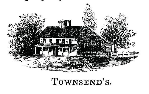


 1796
 1834
 1890
 1890
 1897
 1898
 1900
 1900
 1901
 1901


