Hempstead dates to 1644, and 22% of its homes were built before 1940
More historic than 90% of U.S. towns · #270 of 758 in New York. What drives it
29 places in town are on the National Register, among them four historic districts with 203 buildings between them. Below: 3 old photos and papers, maps from 1886 on, and the census since 1790.
Founding year: Wikipedia. First post office: 1802.The full story ↓
History grade
What drives Hempstead’s History grade
On its age, its old homes and the National Register, Hempstead is more historic than 90% of U.S. towns, #270 of 758 in New York. All 3 inputs are above most U.S. towns; its age ranks highest and its National Register listings lowest.
A
HistoryA character grade: shown, never part of Hempstead’s overall grade.
Among the 400 U.S. cities of 100,000 or more, Hempstead ranks #65 on History.
New York towns list more on the Register than most of the country (a typical New York town has 12.3 per 10,000 residents, the U.S. 2.4), so Hempstead’s 2.9 sits below most of its state (29% of New York towns have fewer) while its 232 historic buildings outnumber those of 94% of U.S. towns.
NoteThe founding year comes from Wikipedia alone; no second source gives 1644.
How sure. Graded on any two of the three inputs instead, the letter would range from A− to A. The pre-1940 share (±0.6 points) is firm at this size.
Founding year: Wikipedia (other dates in Quick answers). Homes: Census ACS 2020–24. National Register: National Park Service, May 2026 list; each listing counted once (boundary changes and added documentation belong to their listing), and a historic district counts its contributing buildings. How TownRatings grades history →
What stands out about Hempstead’s past
Read from the archive, the National Register and the record. The page puts what stands out first.
The town was first settled around 1644 following the establishment of a treaty between English colonists, John Carman and Robert Fordham, and the Lenape Indians in 1643. Although the settlers were from the new English colony of New Haven (established in 1638), later incorporated into Connecticut (1662), a patent was issued by the government of New Netherland after the settlers had purchased land from the local natives. This transaction is depicted in a mural in the Hempstead Village Hall, reproduced from a poster commemorating the 300th anniversary of Hempstead Village.
Convention from Flushing; signed the Petition, with others ; 1658, appointed at Hempstead to settle lines with Indians, acting as Assistant Magistrate ; 1663, Delegate to Hartford from Hempstead, and appointed Magistrate; 1665, Member of Assembly from Hempstead.
Text read by machine from the scan; it may contain errors.
The village of Hempstead was built in one of the large hollows. A tall steeple is almost alone in sight from the open plain, even now. Formal agreements at different dates were made for herdsmen to attend and watch the common drove of cattle, receive them from the owners half an hour after sunrise, and deliver them back half an hour before sundown.
Text read by machine from the scan; it may contain errors.
Scans and text from the Internet Archive. Books published in 1930 or earlier, which are in the public domain.
By decade
Hempstead, decade by decade
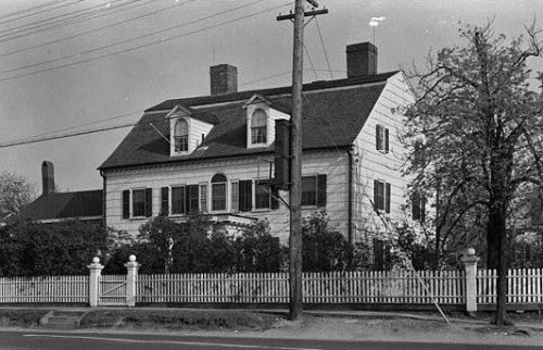
2 decades in the archive, from the 1900s to the 1910s. Scroll each row; tap a photo for its story.
Nothing in the archives for these yearsWeddings on Main Street, storms, parades, school pictures, the old store. If it’s in your family album, it belongs here.
Every edition of the U.S. Geological Survey’s map of Hempstead. Tap a year, or press play to watch the town change.
1897Hempstead sheet · 1:62,500
U.S. Geological Survey historical topographic maps (public domain), via Esri’s collection of the scans. The red ring marks the center of Hempstead.
Every building
Hempstead, building by building, 1886–1919
Fire insurance maps drew every building, what it was made of and what it was used for, so insurers could price the risk of fire. Pick a year, then a sheet.
Aviation Country Club AirportairportBaldwin Golf CourselocaleCalderone TheaterbuildingCamp MillsmilitaryCathedral School of Saint MaryschoolCurtiss Wright AirportairportDaurenheim EstatelocaleDistrict School Number 6schoolEast Meadow ChurchchurchEast Meadow SchoolschoolFine Arts Museum of Long IslandbuildingFranklin Square Grade SchoolschoolFreeport StadiumlocaleHempstead Sewage Disposal PlantlocaleHempstead Town Home HospitalhospitalJerusalem SchoolschoolLake Kathleen Golf CourselocaleLawrence Country Day Schoolschool
16cemeteries and burying grounds inside Hempstead
Beth DavidBethpage United Methodist ChurchBideawee Pet Memorial ParkBryantElmontGreenfieldJacksonJerusalem FriendsMaimonides - ElmontOakfieldRockvilleSaint BonifaceSaint JohnsSaint MarysSaint Pauls German Presbyterian ChurchTrinity
US Post Offices dataset (Blevins & Helbock, CC0). Places and cemeteries from the USGS Geographic Names Information System (2021).
Help out
Start Hempstead’s collection
The first neighbors to add old photos shape how Hempstead’s history is told.
Decades since 1900 with photos
00s10s20s30s40s50s60s70s80s90s
2 of 10 decades. The empty ones are waiting for someone’s album.
In 1644, according to Wikipedia’s history of the town. Hempstead’s post office opened in 1802, and the first U.S. census counted 3,828 people here in 1790.
How does Hempstead rank for history?
Hempstead is more historic than 90% of U.S. towns, #270 of 758 in New York. The History grade combines the town’s founding era, the share of homes built before 1940 and its National Register listings. It’s a character grade, so it isn’t part of the overall grade. How it works.
What is on the National Register in Hempstead?
29 listings: 24 buildings, among them the St. George's Church (listed 1973, the first), 4 historic districts with 203 contributing buildings, and 1 site. 232 historic buildings in all.
How old are the homes in Hempstead?
22% of Hempstead’s homes were built before 1940 (Census estimate), against a typical 27% for a New York town; the median home was built in 1954.
Founding dates: Wikidata, Wikipedia, the U.S. post office records of Blevins & Helbock (CC0) and the Census. Homes by year built: Census ACS 2020–24. National Register of Historic Places: National Park Service (list of May 22, 2026). Old photos, postcards and papers: Wikimedia Commons, the Library of Congress and other public archives, credited on each item’s page. Maps: U.S. Geological Survey historical topographic maps (via Esri) and Sanborn fire-insurance maps (Library of Congress). History text and census tables: Wikipedia (CC BY-SA 4.0). Places that used to be: USGS Geographic Names Information System (2021).
From the Library of Congress (3), the National Register of Historic Places (29), Wikipedia, Wikidata and Wikipedia for famous people, U.S. Geological Survey historical maps, U.S. Census counts (via Wikipedia), the US Post Offices dataset (Blevins & Helbock), the USGS Geographic Names Information System, Sanborn fire insurance maps (Library of Congress) and old county and town histories (Internet Archive). Archive images are copied here with their credits and licenses, shown on each photo’s page. Refreshed monthly.




 1905


