Mamakating dates to 1743, and 18% of its homes were built before 1940
More historic than 92% of U.S. towns · #235 of 758 in New York. What drives it
4 places in town are on the National Register, among them a historic district with 45 buildings. Below: 1 old photo or paper, maps from 1904 on, and the census since 1790.
Founding year: Wikipedia. First post office: 1817.The full story ↓
History grade
What drives Mamakating’s History grade
On its age, its old homes and the National Register, Mamakating is more historic than 92% of U.S. towns, #235 of 758 in New York. All 3 inputs are above most U.S. towns; its age ranks highest and its share of homes from before 1940 lowest.
A
HistoryA character grade: shown, never part of Mamakating’s overall grade.
New York towns list more on the Register than most of the country (a typical New York town has 12.3 per 10,000 residents, the U.S. 2.4), so Mamakating’s 39.3 sits above most of its state (65% of New York towns have fewer) while its 50 historic buildings outnumber those of 85% of U.S. towns.
NoteThe founding year comes from Wikipedia alone; no second source gives 1743.
How sure. Graded on any two of the three inputs instead, the letter would range from A− to A. The pre-1940 share is a Census survey estimate (±3.9 points).
Founding year: Wikipedia (other dates in Quick answers). Homes: Census ACS 2020–24. National Register: National Park Service, May 2026 list; each listing counted once (boundary changes and added documentation belong to their listing), and a historic district counts its contributing buildings. How TownRatings grades history →
What stands out about Mamakating’s past
Read from the archive, the National Register and the record. The page puts what stands out first.
Lost post offices, old corners, places now gone and burying grounds
Mamakating had its own post office from 1817 to 1830. Eight other post offices opened and closed inside today’s town.
Mamakating
1817–1830
Summitville
1826–1828
Bloomingburg
1827–today
Philipsport
1828–today
Wurtsboro
1830–today
Burlingham
1840–today
Mamakating
1850–1866
Winterton
1871–1957
Summitville
1872–today
Highview
1890–1966
18101920today
Hamlets and corners on the map
BloomingburgBlue Sky Manor Mobile Home ParkBurlinghamCulvertownHavenHigh ViewMamakating ParkMount ProsperMount VernonNew Twin Lakes Mobile Home ParkPhillipsportRiver Edge Mobile Home ParkRoosa GapSummitvilleWhispering Pines Mobile Home ParkWintertonWurtsboroWurtsboro HillsYankee Lake
Gone or out of use
Bloomingburg SchoolschoolBurlingham SchoolschoolGumaer SchoolschoolMamakating StationlocaleMount Vernon SchoolschoolNew Vernon SchoolschoolPhillipsport SchoolschoolPleasant Valley SchoolschoolRoosa Gap SchoolschoolSandburg Bend SchoolschoolSummitville SchoolschoolWinterton Schoolschool
5cemeteries and burying grounds inside Mamakating
Belle TerreChester Stanton MemorialNew VernonPoplar GroveSylvan
US Post Offices dataset (Blevins & Helbock, CC0). Places and cemeteries from the USGS Geographic Names Information System (2021).
Help out
Start Mamakating’s collection
The first neighbors to add old photos shape how Mamakating’s history is told.
Decades since 1900 with photos
00s10s20s30s40s50s60s70s80s90s
0 of 10 decades. The empty ones are waiting for someone’s album.
Johanis Hardenburgh, a resident of Kingston, Ulster County, had purchased a large tract of land known as the Hardenburgh Patent in 1706. This land and another patent known as the Minisink Patent were what is now most of Orange and Sullivan Counties.
The town of Mamakating was organized on December 17, 1743, as the Precinct of Mamakating in Ulster County, and was coextensive with what became Sullivan County. Some say it was called Mamacotten. Over decades, the precinct was partitioned into towns. The Town of Mamakating is considered the first town in Sullivan County; its first county seat was raised in the village of Bloomingburg in 1809.
Some time after the completion of the Newburgh and Cocheoton turnpike, and the establishment of a post-office, the official designation of the village was Mamakating, while the popular appellation was "Mammy Cotton Holler.' Mamakating consisted of about a score of houses clustered around the corners of the turnpike and the old Minisink road.
Text read by machine from the scan; it may contain errors.
Scans and text from the Internet Archive. Books published in 1930 or earlier, which are in the public domain.
Timeline
Mamakating, 1743 to 2020
Woven from the archive, old maps, post office records, the National Register and the people born here.
In 1743, according to Wikipedia’s history of the town. Mamakating’s post office opened in 1817, and the first U.S. census counted 1,763 people here in 1790.
How does Mamakating rank for history?
Mamakating is more historic than 92% of U.S. towns, #235 of 758 in New York. The History grade combines the town’s founding era, the share of homes built before 1940 and its National Register listings. It’s a character grade, so it isn’t part of the overall grade. How it works.
What is on the National Register in Mamakating?
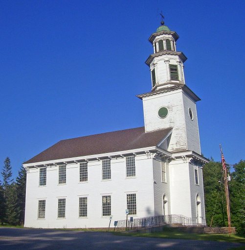
4 listings: 3 buildings, among them the Bloomingburg Reformed Protestant Dutch Church (listed 1980, the first), and 1 historic district, the Mamakating Park Historic District, with 45 contributing buildings. 50 historic buildings in all.
How old are the homes in Mamakating?
18% of Mamakating’s homes were built before 1940 (Census estimate, ±3.9 points), against a typical 27% for a New York town; the median home was built in 1973.
Founding dates: Wikidata, Wikipedia, the U.S. post office records of Blevins & Helbock (CC0) and the Census. Homes by year built: Census ACS 2020–24. National Register of Historic Places: National Park Service (list of May 22, 2026). Old photos, postcards and papers: Wikimedia Commons, the Library of Congress and other public archives, credited on each item’s page. Maps: U.S. Geological Survey historical topographic maps (via Esri) and Sanborn fire-insurance maps (Library of Congress). History text and census tables: Wikipedia (CC BY-SA 4.0). Places that used to be: USGS Geographic Names Information System (2021).
From Wikimedia Commons (12), the National Register of Historic Places (4), Wikipedia, U.S. Geological Survey historical maps, U.S. Census counts (via Wikipedia), the US Post Offices dataset (Blevins & Helbock), the USGS Geographic Names Information System and old county and town histories (Internet Archive). Archive images are copied here with their credits and licenses, shown on each photo’s page. Refreshed monthly.


 2026
 2026
 2026
 2026
 2026
 2026
 2025
 2023
 2020
 2008
 2007