
The story
Read it all →How Forestburgh came to be
From Wikipedia’s history of Forestburgh.
The town was formed from parts of the Towns of Mamakating and Thompson in 1837.
Text from Wikipedia, licensed CC BY-SA 4.0.
Each edition grades its towns against each other only.
Its Register listing is the Forestburgh Town Hall. Below: 2 old photos and papers, maps from 1909 on, and the census since 1840.
Read from the archive, the National Register and the record. The page puts what stands out first.
Five other post offices opened and closed inside today’s town.
US Post Offices dataset (Blevins & Helbock, CC0). Places and cemeteries from the USGS Geographic Names Information System (2021).
The first neighbors to add old photos shape how Forestburgh’s history is told.
Lost two-thirds of its people between 1880 and 1960, then more than doubled.
19 censuses, 1840–2020.
U.S. Census Bureau decennial counts, from the census table on Forestburgh’s Wikipedia page.
From Wikipedia’s history of Forestburgh.
The town was formed from parts of the Towns of Mamakating and Thompson in 1837.
Text from Wikipedia, licensed CC BY-SA 4.0.
Passages that mention Forestburgh, cut from the printed page as they were published.

Mr. Bumham has been a resident of Monticello during the last thirty years, and yet loves to give the particulars of his bear-hunt in Forestburgh. It may be said of some communities that the history of their Churches is a history of the people. Forestburgh, in its early days, was occupied by lumbermen; consequently saw-miUs enter largely into the account of its settlement.
Text read by machine from the scan; it may contain errors.Scans and text from the Internet Archive. Books published in 1930 or earlier, which are in the public domain.
Woven from the archive, old maps, post office records, the National Register and the people born here.
 In the archiveCounty atlas of Sullivan, New York
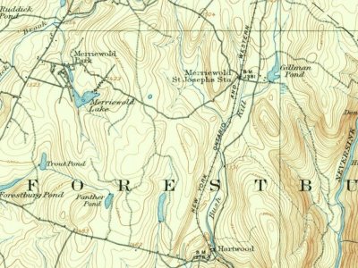 On the mapFirst mapped by the U.S. Geological Survey
One decade in the archive so far: the 1870s. Scroll each row; tap a photo for its story.
 2023Forestburgh, NY 42 nb (2), July 2023
 2023Forestburgh, NY 42 nb (1), July 2023
 2020Neversink River at Oakland Valley, NY
 2020Mullet Falls in the Neversink Gorge
 2014Interior of Forestburg (NY) Town Hall
 2014Forestburg Town Hall outbuilding
 2014Forestburg (NY) Town Hall, 1929
 2006New York State Route 42 091606 111
Every edition of the U.S. Geological Survey’s map of Forestburgh. Tap a year, or press play to watch the town change.

U.S. Geological Survey historical topographic maps (public domain), via Esri’s collection of the scans. The red ring marks the center of Forestburgh.
The country’s official list of buildings and places worth saving.
National Park Service, National Register of Historic Places. Photos from Wikimedia Commons, credited on each place’s page.
Nobody well known was born in Forestburgh itself, so here are the best known from just nearby.


Each neighbor’s History grade, on the same three inputs.
One place: the Forestburgh Town Hall (listed 2011).
What the archives can’t tell you, neighbors can.
Founding dates: Wikidata, Wikipedia, the U.S. post office records of Blevins & Helbock (CC0) and the Census. Homes by year built: Census ACS 2020–24. National Register of Historic Places: National Park Service (list of May 22, 2026). Old photos, postcards and papers: Wikimedia Commons, the Library of Congress and other public archives, credited on each item’s page. Maps: U.S. Geological Survey historical topographic maps (via Esri) and Sanborn fire-insurance maps (Library of Congress). History text and census tables: Wikipedia (CC BY-SA 4.0). Places that used to be: USGS Geographic Names Information System (2021). How TownRatings grades history →
From Wikimedia Commons (10), the National Register of Historic Places (1), Wikipedia, U.S. Geological Survey historical maps, U.S. Census counts (via Wikipedia), the US Post Offices dataset (Blevins & Helbock), the USGS Geographic Names Information System and old county and town histories (Internet Archive). Archive images are copied here with their credits and licenses, shown on each photo’s page. Refreshed monthly.
 1875


