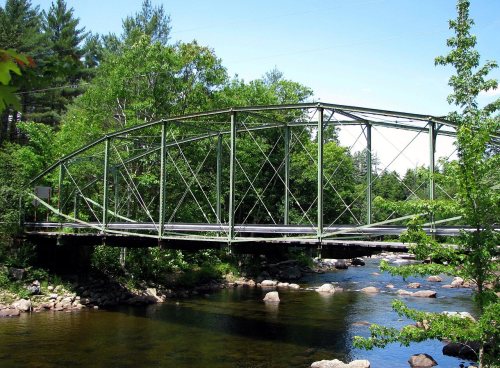
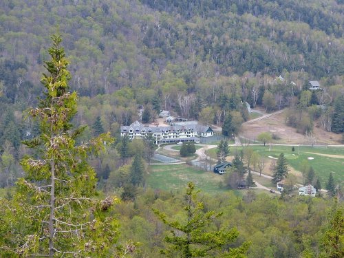
10 places in town are on the National Register, among them two historic districts with 15 buildings between them. Below: 4 old photos and papers, maps from 1896 on, and the census since 1820.
The Keene post office opened in 1818, the earliest record of the town by name. Two smaller post offices, Keene Flats (1864) and Saint Huberts (1903), opened inside today’s town and later closed.
First census: 605 in 18202020 census: 1,144208 years
How historic is Keene?
A+
More historic than 95% of U.S. towns, on its age, its old homes and the National Register.
Founding year: the first Keene post office (Blevins & Helbock, CC0).The full story ↓
History grade
What drives Keene’s History grade
On its age, its old homes and the National Register, Keene is more historic than 95% of U.S. towns. All 3 inputs are above most U.S. towns; its share of homes from before 1940 ranks highest and its age lowest.
A+
HistoryA character grade: shown, never part of Keene’s overall grade.
New York towns list more on the Register than most of the country (a typical New York town has 12.3 per 10,000 residents, the U.S. 2.4), so Keene’s 451 sits above most of its state (91% of New York towns have fewer) while its 32 historic buildings outnumber those of 82% of U.S. towns.
How sure. Graded on any two of the three inputs instead, the letter would range from A to A+. The pre-1940 share is a Census survey estimate (±6.7 points). The founding year is the first post office, not a stated founding date.
Founding year: the first post office (other dates in Quick answers). Homes: Census ACS 2020–24. National Register: National Park Service, May 2026 list; each listing counted once (boundary changes and added documentation belong to their listing), and a historic district counts its contributing buildings. How TownRatings grades history →
What stands out about Keene’s past
Read from the archive, the National Register and the record. The page puts what stands out first.
The earliest settlement in the present village of Keene Center was in 1787. The town of Keene was created from splitting parts of the towns of Jay and Elizabethtown on March 19, 1808. This originally included current North Elba, but that was split in 1849 from the original Keene. The area is mountainous with bedrock close to the surface in most areas, leaving little arable land. It has a low population due to the unsuitable and often unstable soil in the region. A road along the Ausable River from Jay was extended south to Keene Center about 1797, but it was often deemed almost impassible due to the structure of the area. The town of Keene organized the first school district in the Adirondacks, which held its first recorded trustee meeting in 1813.
Passages that mention Keene, cut from the printed page as they were published.
Leading manufacturers and merchants of New Hampshire1887 · page 213Read the page →
Read the text
the former place it connects with the Fitchburg Railroad for Boston, and at the latter with the Central Vermont for the interior of the state, Canada and with the steamers plying on the great lakes. At the same place connection is also made with the Rutland Railroad, and subsequently with the Delaware and Hudson Railroad line to Troy, Albany and the West. From Keene to Boston the Cheshire line is one hour quicker than any other route, the running time being but three hours. From Worcester and Providence to all Canadian points this line offers twenty-eight miles less travel and faster trains. The principal offices of the road are located in the depot building at Keene.
Text read by machine from the scan; it may contain errors.
Truman Rice, a brother of Amos Rice, lived just west of Elizabethtown village on "the old Keene road," so-called. "The old Keene road" ran diagonally across what is now the Cobble Hill Golf Ground, thence through the woods (where the old road is plainly visible to this day) and thence past the Truman Rice home and so on over the hill, coming into the present highway leading from Elizabethtown village to Keene at a point near the residence of Wm. H. McDougal. Truman Rice was
Text read by machine from the scan; it may contain errors.
There was also a saw-mill at the Miller settlement on the road to Keene and one in the southwestern part of the town, known for many years as the Yaw mill. Whallon and Judd had a saw-mill which they operated at the Valley Forge settlement.
Text read by machine from the scan; it may contain errors.
Scans and text from the Internet Archive. Books published in 1930 or earlier, which are in the public domain.
Timeline
Keene, 1815 to 1952
Woven from the archive, old maps, post office records, the National Register and the people born here.
Nothing in the archives for these yearsWeddings on Main Street, storms, parades, school pictures, the old store. If it’s in your family album, it belongs here.
The Keene post office opened in 1818, the earliest record of the town by name (U.S. post office records).
How does Keene rank for history?
Keene is more historic than 95% of U.S. towns. The History grade combines the town’s founding era, the share of homes built before 1940 and its National Register listings. It’s a character grade, so it isn’t part of the overall grade. How it works.
What is on the National Register in Keene?
10 listings: 3 buildings, 2 historic districts, the Putnam Camp and the Keene Valley Country Club, with 15 contributing buildings, and 5 structures. 32 historic buildings in all.
How old are the homes in Keene?
34% of Keene’s homes were built before 1940 (Census estimate, ±6.7 points), against a typical 27% for a New York town; the median home was built in 1967.
Founding dates: Wikidata, Wikipedia, the U.S. post office records of Blevins & Helbock (CC0) and the Census. Homes by year built: Census ACS 2020–24. National Register of Historic Places: National Park Service (list of May 22, 2026). Old photos, postcards and papers: Wikimedia Commons, the Library of Congress and other public archives, credited on each item’s page. Maps: U.S. Geological Survey historical topographic maps (via Esri) and Sanborn fire-insurance maps (Library of Congress). History text and census tables: Wikipedia (CC BY-SA 4.0). Places that used to be: USGS Geographic Names Information System (2021).
From Wikimedia Commons (12), the National Register of Historic Places (10), Wikipedia, Wikidata and Wikipedia for famous people, U.S. Geological Survey historical maps, U.S. Census counts (via Wikipedia), the US Post Offices dataset (Blevins & Helbock), the USGS Geographic Names Information System and old county and town histories (Internet Archive). Archive images are copied here with their credits and licenses, shown on each photo’s page. Refreshed monthly.


 1888
 1905
 2010
 2010
 2010
 2010
 2009
 2008
 2008
 2008