Goshen dates to 1788, and 20% of its homes were built before 1940
More historic than 88% of U.S. towns · #293 of 758 in New York. What drives it
10 places in town are on the National Register, among them the Historic Track, a National Historic Landmark, and two historic districts with 110 buildings between them. Below: 4 old photos and papers, maps from 1885 on, and the census since 1790.
Founding year: Wikipedia. First post office: 1792.The full story ↓
History grade
What drives Goshen’s History grade
On its age, its old homes and the National Register, Goshen is more historic than 88% of U.S. towns, #293 of 758 in New York. All 3 inputs are above most U.S. towns; its National Register listings ranks highest and its share of homes from before 1940 lowest.
A
HistoryA character grade: shown, never part of Goshen’s overall grade.
New York towns list more on the Register than most of the country (a typical New York town has 12.3 per 10,000 residents, the U.S. 2.4), so Goshen’s 84.3 sits above most of its state (73% of New York towns have fewer) while its 122 historic buildings outnumber those of 90% of U.S. towns.
NoteThe founding year comes from Wikipedia alone; no second source gives 1788.
How sure. Graded on any two of the three inputs instead, the letter would range from A− to A. The pre-1940 share is a Census survey estimate (±4.6 points).
Founding year: Wikipedia (other dates in Quick answers). Homes: Census ACS 2020–24. National Register: National Park Service, May 2026 list; each listing counted once (boundary changes and added documentation belong to their listing), and a historic district counts its contributing buildings. How TownRatings grades history →
What stands out about Goshen’s past
Read from the archive, the National Register and the record. The page puts what stands out first.
The country’s official list of buildings and places worth saving. One is a National Historic Landmark, the highest tier. Boundary changes and added documentation are counted with their listing.
National Park Service, National Register of Historic Places. Photos from Wikimedia Commons, credited on each place’s page.
Places that used to be
Lost post offices, old corners, places now gone and burying grounds
Goshen’s post office has been open since 1792. Three other post offices opened and closed inside today’s town.
Goshen
1792–today
Florida
1804–today
Durlandville
1882–1887
Orange Farm
1887–1889
Durlandville
1915–1926
17901910today
Hamlets and corners on the map
DurlandvilleFinnegans CornersHowellOtter KillPellets Island
Gone or out of use
Big Island AirportairportDuchess QuarrymineGarr InstituteschoolGood Time StableslocaleGoshen Emergency HospitalhospitalGoshen TheatrebuildingNew Hampton Training SchoolschoolOrange County JailbuildingOrange FarmlocaleSara Wells Airportairport
5cemeteries and burying grounds inside Goshen
Saint JamesSaint JohnsSlate HillVeterans MemorialWebb
US Post Offices dataset (Blevins & Helbock, CC0). Places and cemeteries from the USGS Geographic Names Information System (2021).
European settlement began around 1714, although plans for this were made beginning about 1654. The town was established in 1788, after the American Revolutionary War and New York becoming a state. As population increased in the area, in 1830, part of Goshen was divided off to form the new Town of Hamptonburgh. In 1845, another part was used to form the Town of Chester.
After reaching his majority, until 1854, he carried on farming in Vernon, Bergen County, Wantage, and a second time in Vernon, N. J., when he purchased five hundred acres of land in the town of Goshen, a part of which he subsequently sold. In 1856 he purchased his present farm of one hundred and fifty acres, located within the corporate limits of the village of Goshen.
Text read by machine from the scan; it may contain errors.
In 1763, Lieutenant-Governor Cadwallader Golden appealed to the General Assembly for troops to relieve the militia on the borders of Orange and Ulster which were infested by the enemy. At this time the town of Goshen extended from the Hudson to New Jersey. In 1764 a bill was passed dividing the precinct of Goshen into two precincts, to be called Goshen and Cornwall. After this division Cornwall embraced the present towns of Cornwall, Monroe and Blooming Grove, while Goshen included the present town of Warwick.
Text read by machine from the scan; it may contain errors.
through the town of Wallkill, to the town of Goshen, and thence to the village of Goshen. An example of the enterprise of the tov.-n of Wallkill was manifested when the question of raising money for the construction of the Xew York & Oswego Midland Railroad came up in 1867. Its citizens, under the wise leadership and giiided by the excellent judgment of Senator Henry R. Low, Captain James N. Pronk, Elislia P. Wheeler, William J.
Text read by machine from the scan; it may contain errors.
History of Orange County, New York1881 · page 181Read the page →
Read the text
The meetings of the society were for a series of years held annually, the first having been convened at Goshen in 1806. As the organization increased in numbers and influence, the importance of more frequent conferences became apparent, and semi-annual meetings were instituted, the first of which was appointed at the house of Dr. Daniel Seward, in the village of Goshen, on the first day of July, 1817. They
Text read by machine from the scan; it may contain errors.
Scans and text from the Internet Archive. Books published in 1930 or earlier, which are in the public domain.
Timeline
Goshen, 1788 to 1985
Woven from the archive, old maps, post office records, the National Register and the people born here.
Nothing in the archives for these yearsWeddings on Main Street, storms, parades, school pictures, the old store. If it’s in your family album, it belongs here.
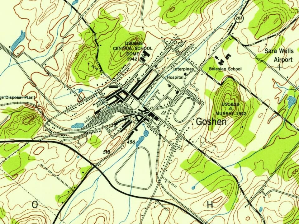
Every edition of the U.S. Geological Survey’s map of Goshen. Tap a year, or press play to watch the town change.
1906Goshen sheet · 1:62,500
U.S. Geological Survey historical topographic maps (public domain), via Esri’s collection of the scans. The red ring marks the center of Goshen.
Every building
Goshen, building by building, 1885–1915
Fire insurance maps drew every building, what it was made of and what it was used for, so insurers could price the risk of fire. Pick a year, then a sheet.
In 1788, according to Wikipedia’s history of the town. Goshen’s post office opened in 1792, and the first U.S. census counted 2,448 people here in 1790.
How does Goshen rank for history?
Goshen is more historic than 88% of U.S. towns, #293 of 758 in New York. The History grade combines the town’s founding era, the share of homes built before 1940 and its National Register listings. It’s a character grade, so it isn’t part of the overall grade. How it works.
What is on the National Register in Goshen?
10 listings: 8 buildings and 2 historic districts, the Historic Track and the Church Park Historic District, with 110 contributing buildings. 122 historic buildings in all.
How old are the homes in Goshen?
20% of Goshen’s homes were built before 1940 (Census estimate, ±4.6 points), against a typical 27% for a New York town; the median home was built in 1976.
Founding dates: Wikidata, Wikipedia, the U.S. post office records of Blevins & Helbock (CC0) and the Census. Homes by year built: Census ACS 2020–24. National Register of Historic Places: National Park Service (list of May 22, 2026). Old photos, postcards and papers: Wikimedia Commons, the Library of Congress and other public archives, credited on each item’s page. Maps: U.S. Geological Survey historical topographic maps (via Esri) and Sanborn fire-insurance maps (Library of Congress). History text and census tables: Wikipedia (CC BY-SA 4.0). Places that used to be: USGS Geographic Names Information System (2021).
From the Library of Congress (4), Wikidata (1), the National Register of Historic Places (10), Wikipedia, Wikidata and Wikipedia for famous people, U.S. Geological Survey historical maps, U.S. Census counts (via Wikipedia), the US Post Offices dataset (Blevins & Helbock), the USGS Geographic Names Information System, Sanborn fire insurance maps (Library of Congress) and old county and town histories (Internet Archive). Archive images are copied here with their credits and licenses, shown on each photo’s page. Refreshed monthly.


 ★ Landmark


 1930
 1930
 Date?