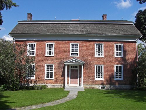
Danube dates to 1730, and 37% of its homes were built before 1940
Its Register listings are the Herkimer House, the Indian Castle Church and the Zoller-Frasier Round Barn. Below: 1 old photo or paper, maps from 1900 on, and the census since 1820.
Lost post offices, old corners, places now gone and burying grounds
Danube had its own post office from 1818 to 1903. Another post office, Newville, opened and closed inside today’s town.
Danube
1818–1903
Newville
1825–1922
18101920today
Hamlets and corners on the map
Fink BasinHomestead Mobile ParkIndian CastleNewville
Gone or out of use
Crystal Springs SchoolschoolFrog City SchoolschoolParadise SchoolschoolSchool Number 1schoolSchool Number 3schoolSchool Number 4schoolSchool Number 5school
The town was first settled by Europeans around 1730 on the territories of Lindsey's (1730) and Van Horne's (1731) patents. The town was within the territory of the Mohawk people.
In coordination with the colonial government, the Mohawk had allowed a fortified settlement east of here. They had agreed in 1712 to allow some settlement by Palatine Germans in exchange for Queen Anne helping with their defense against the French and Indian allies. Fort Schuyler was constructed south of the Mohawk River near one of their major settlements at the time.
The town of Danube was formed in 1817 from the town of Minden (in Montgomery County). Part of Danube was taken off in 1828 to form the town of Stark.
Passages that mention Danube, cut from the printed page as they were published.
History of Herkimer county, New York1893 · page 78Read the page →
Read the text
prove the ground and erect a monument to mark the place where the body of General Merkimer is buried This is a matter which concerns every patriotic person, for General Herkimer won the pivotal battle of the Revolution. His body now lies in a pasture in the town of Danube, midway between Little Falls and Indian Castle. The surroundings are unfit, and the stone which marks the grave is not such as should grace the resting place of the hero of Oriskany.
Text read by machine from the scan; it may contain errors.
Scans and text from the Internet Archive. Books published in 1930 or earlier, which are in the public domain.
Founding dates: Wikidata, Wikipedia, the U.S. post office records of Blevins & Helbock (CC0) and the Census. Homes by year built: Census ACS 2020–24. National Register of Historic Places: National Park Service (list of May 22, 2026). Old photos, postcards and papers: Wikimedia Commons, the Library of Congress and other public archives, credited on each item’s page. Maps: U.S. Geological Survey historical topographic maps (via Esri) and Sanborn fire-insurance maps (Library of Congress). History text and census tables: Wikipedia (CC BY-SA 4.0). Places that used to be: USGS Geographic Names Information System (2021). How TownRatings grades history →
From Wikimedia Commons (1), the Library of Congress (1), the National Register of Historic Places (3), Wikipedia, Wikidata and Wikipedia for famous people, U.S. Geological Survey historical maps, U.S. Census counts (via Wikipedia), the US Post Offices dataset (Blevins & Helbock), the USGS Geographic Names Information System and old county and town histories (Internet Archive). Archive images are copied here with their credits and licenses, shown on each photo’s page. Refreshed monthly.


 Date?
 2012