Clayton’s post office opened in 1834, and 30% of its homes were built before 1940
More historic than 92% of U.S. towns · #219 of 758 in New York. What drives it
5 places in town are on the National Register, among them a historic district with 36 buildings. Below: 11 old photos and papers, maps from 1884 on, and the census since 1840.
The Clayton post office opened in 1834, the earliest record of the town by name. Six smaller post offices, Catfish Falls (1822), French Creek (1822) and Cornelia (1825), opened inside today’s town and later closed.
First census: 3,990 in 18402020 census: 4,770192 years
How historic is Clayton?
A
More historic than 92% of U.S. towns, on its age, its old homes and the National Register.
Founding year: the first Clayton post office (Blevins & Helbock, CC0).The full story ↓
History grade
What drives Clayton’s History grade
On its age, its old homes and the National Register, Clayton is more historic than 92% of U.S. towns, #219 of 758 in New York. All 3 inputs are above most U.S. towns; its share of homes from before 1940 ranks highest and its age lowest.
A
HistoryA character grade: shown, never part of Clayton’s overall grade.
New York towns list more on the Register than most of the country (a typical New York town has 12.3 per 10,000 residents, the U.S. 2.4), so Clayton’s 87.4 sits above most of its state (74% of New York towns have fewer) while its 41 historic buildings outnumber those of 84% of U.S. towns.
How sure. Graded on any two of the three inputs instead, the letter would range from A− to A. The pre-1940 share is a Census survey estimate (±5.1 points). The founding year is the first post office, not a stated founding date.
Founding year: the first post office (other dates in Quick answers). Homes: Census ACS 2020–24. National Register: National Park Service, May 2026 list; each listing counted once (boundary changes and added documentation belong to their listing), and a historic district counts its contributing buildings. How TownRatings grades history →
What stands out about Clayton’s past
Read from the archive, the National Register and the record. The page puts what stands out first.
Lost post offices, old corners, places now gone and burying grounds
Clayton’s post office has been open since 1834. Six other post offices opened and closed inside today’s town.
Catfish Falls
1822–1825
French Creek
1822–1825
Cornelia
1825–1834
Depauville
1825–today
Clayton
1834–today
Clayton Centre
1855–1873
Grindstone
1880–1974
Thurso
1883–1896
Frontenac
1889–today
Grenell
1894–today
18201920today
Hamlets and corners on the map
Clayton CenterDepauvilleFrontenacGrenellGrindstoneLawrence View Mobile Home ParkLower Town LandingRainbow Shores Mobile Home ParkReynolds CornerUpper Town Landing
Gone or out of use
School Number 1schoolSchool Number 10schoolSchool Number 12schoolSchool Number 14schoolSchool Number 15schoolSchool Number 19schoolSchool Number 2schoolSchool Number 4schoolSchool Number 7schoolSchool Number 9schoolSpicer Bay Schoolschool
4cemeteries and burying grounds inside Clayton
CorbinDutchThursoWeaver
US Post Offices dataset (Blevins & Helbock, CC0). Places and cemeteries from the USGS Geographic Names Information System (2021).
On the map
Clayton on the map, 1900 to 1958
Every edition of the U.S. Geological Survey’s map of Clayton. Tap a year, or press play to watch the town change.
1900Clayton sheet · 1:62,500
U.S. Geological Survey historical topographic maps (public domain), via Esri’s collection of the scans. The red ring marks the center of Clayton.
On the National Register
5 listings protect 41 historic buildings
The country’s official list of buildings and places worth saving. Boundary changes and added documentation are counted with their listing.
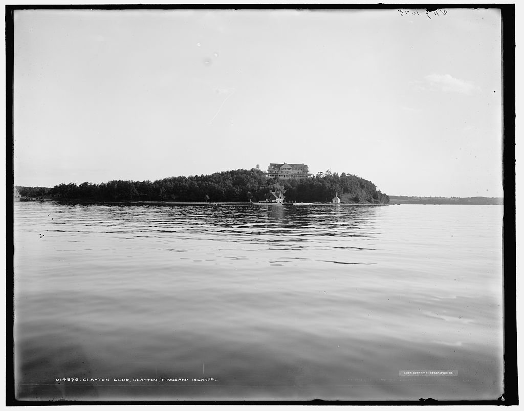
The town was formed from parts of the towns of Orleans and Lyme in 1833. The town was named after statesman John M. Clayton. The village of Clayton became the main railroad terminus for the Thousand Islands resort region, during its heyday at the turn of the twentieth century. The town of Clayton offered several hotels to visitors, some grand, now mostly vanished.
In 1872, the community of Clayton voted to set itself apart from the town by incorporating as a village.
Fairview Manor, Swarthout Site-A04507.000038, and Grindstone Island Upper Schoolhouse are listed on the National Register of Historic Places.
Passages that mention Clayton, cut from the printed page as they were published.
History of Jefferson County, New York1878 · page 122Read the page →
Read the text
by-laws was adopted, and the following resolutions passed : "Resolved, That it is our intention to construct a railroad, from the central line of railroad and Erie canal, in the Tillage of Rome, to the river St. Lawrence, in the village of Clayton, and also to said river St. Lawrence, in the village of Ogdensburgh, and touching the river at Morristown, so as to connect with the Northern Ogdensburgh Railroad, and the Grand Trunk Railroad, the By Town and Prescott Railroad, and the proposed Pembroke and Brockville Railroad in
Text read by machine from the scan; it may contain errors.
History of Clayton County, Iowa1916 · page 397Read the page →
Read the text
He took an active part in the organization of Clayton County, and held the first justice court within its limits. He was the first clerk of the Board of Clayton County Commissioners, was elected the first School Fund Commissioner, and served one term as a Judge of Probate. In 1850 he took the United States census of the counties of Clayton, Fayette, Winneshiek and Allamakee.
Text read by machine from the scan; it may contain errors.
History of Clayton County, Iowa1916 · page 191Read the page →
Read the text
adventure that prompted him from the first to encounter the trials and hardships of a frontier life again took possession of his mind. He resigned the office of sheriff, crossed the Mississippi and settled on the soil of Clayton county in 1839, where he remained until death closed his eyes forever. Soon after he came to Clayton county he was chosen clerk of the commissioners court, and it was here that his talents and ability as an officer were first discovered by the people of Clayton county, and which laid the foundation for that long and useful career
Text read by machine from the scan; it may contain errors.
History of Jefferson County, New York1878 · page 112Read the page →
Read the text
to be opened, at the expense of the French company, a route from the High Falls, east of Black river, to near the Great Bend, from which it continued in a line nearly direct to the present village of Clayton. A branch from this diverged to the head of navigation on Black River bay, but these roads, though cleared and the stumps removed, had no bridges, and, consequently, were of no use to the early settlers. It is said, as an evidence of the incompetence of this
Text read by machine from the scan; it may contain errors.
Scans and text from the Internet Archive. Books published in 1930 or earlier, which are in the public domain.
Timeline
Clayton, 1822 to 1914
Woven from the archive, old maps, post office records, the National Register and the people born here.
Nothing in the archives for these yearsWeddings on Main Street, storms, parades, school pictures, the old store. If it’s in your family album, it belongs here.
Fire insurance maps drew every building, what it was made of and what it was used for, so insurers could price the risk of fire. Pick a year, then a sheet.
The Clayton post office opened in 1834, the earliest record of the town by name (U.S. post office records).
How does Clayton rank for history?
Clayton is more historic than 92% of U.S. towns, #219 of 758 in New York. The History grade combines the town’s founding era, the share of homes built before 1940 and its National Register listings. It’s a character grade, so it isn’t part of the overall grade. How it works.
What is on the National Register in Clayton?
5 listings: 4 buildings, among them the Capt. Simon Johnston House (listed 1982, the first), and 1 historic district, the Clayton Historic District, with 36 contributing buildings. 41 historic buildings in all.
How old are the homes in Clayton?
30% of Clayton’s homes were built before 1940 (Census estimate, ±5.1 points), against a typical 27% for a New York town; the median home was built in 1976.
Founding dates: Wikidata, Wikipedia, the U.S. post office records of Blevins & Helbock (CC0) and the Census. Homes by year built: Census ACS 2020–24. National Register of Historic Places: National Park Service (list of May 22, 2026). Old photos, postcards and papers: Wikimedia Commons, the Library of Congress and other public archives, credited on each item’s page. Maps: U.S. Geological Survey historical topographic maps (via Esri) and Sanborn fire-insurance maps (Library of Congress). History text and census tables: Wikipedia (CC BY-SA 4.0). Places that used to be: USGS Geographic Names Information System (2021).
From Wikimedia Commons (4), the Library of Congress (7), the National Register of Historic Places (5), Wikipedia, Wikidata and Wikipedia for famous people, U.S. Geological Survey historical maps, U.S. Census counts (via Wikipedia), the US Post Offices dataset (Blevins & Helbock), the USGS Geographic Names Information System, Sanborn fire insurance maps (Library of Congress) and old county and town histories (Internet Archive). Archive images are copied here with their credits and licenses, shown on each photo’s page. Refreshed monthly.




 1864
 1902
 1905
 1905
 1905
 1905
 1905

