Orleans dates to 1806, and 38% of its homes were built before 1940
More historic than 98% of U.S. towns · #56 of 758 in New York. What drives it
20 places in town are on the National Register, among them a historic district with 294 buildings. Below: 1 old photo or paper, maps from 1903 on, and the census since 1830.
Founding year: Wikipedia. First post office: 1822.The full story ↓
History grade
What drives Orleans’ History grade
On its age, its old homes and the National Register, Orleans is more historic than 98% of U.S. towns, #56 of 758 in New York. All 3 inputs are above most U.S. towns; its National Register listings ranks highest and its age lowest.
A+
HistoryA character grade: shown, never part of Orleans’ overall grade.
New York towns list more on the Register than most of the country (a typical New York town has 12.3 per 10,000 residents, the U.S. 2.4), so Orleans’ 1,224 sits above most of its state (97% of New York towns have fewer) while its 340 historic buildings outnumber those of 96% of U.S. towns.
NoteThe founding year comes from Wikipedia alone; no second source gives 1806.
How sure. Graded on any two of the three inputs instead, the letter would range from A to A+. The pre-1940 share is a Census survey estimate (±5.6 points).
Founding year: Wikipedia (other dates in Quick answers). Homes: Census ACS 2020–24. National Register: National Park Service, May 2026 list; each listing counted once (boundary changes and added documentation belong to their listing), and a historic district counts its contributing buildings. How TownRatings grades history →
What stands out about Orleans’ past
Read from the archive, the National Register and the record. The page puts what stands out first.
National Park Service, National Register of Historic Places. Photos from Wikimedia Commons, credited on each place’s page.
Places that used to be
Lost post offices, old corners, places now gone and burying grounds
Five other post offices opened and closed inside today’s town.
Collin's Mills
1822–1832
Lafargeville
1824–today
Stone Mills
1832–1912
Omar
1840–1935
Orleans Four Corners
1849–1916
Fishers Landing
1874–today
Thousand Island Park
1876–today
Grand View Park
1892–1917
Fineview
1902–today
18201920today
Hamlets and corners on the map
Collins LandingFineviewFishers LandingGrandview ParkLa FargevilleMoore LandingOmarOrleans Four CornersShady Bay Mobile Home ParkStone MillsThousand Island Park
Gone or out of use
School Number 18schoolSchool Number 19schoolSchool Number 3schoolSchool Number 8schoolTims Angus Farm Airportairport
5cemeteries and burying grounds inside Orleans
Beech RidgeGroveOrleansRousesSaint Johns
US Post Offices dataset (Blevins & Helbock, CC0). Places and cemeteries from the USGS Geographic Names Information System (2021).
Help out
Start Orleans’s collection
The first neighbors to add old photos shape how Orleans’s history is told.
Decades since 1900 with photos
00s10s20s30s40s50s60s70s80s90s
0 of 10 decades. The empty ones are waiting for someone’s album.
The Oneida tribe granted land, a 100-square-mile (260 km2) tract, in the town to Peter Penet in 1788. The town was first settled around 1806.
The community of La Fargeville was founded around 1816 by the construction of a mill on the Chaumont River.
The town of Orleans was formed from part of the town of Brownville in 1821 at the same time as some other new towns.
Fordham University was founded as St. John's College in La Fargeville in 1838 by a purchase of the lands and home of John La Farge. The college moved to New York City after a few years.
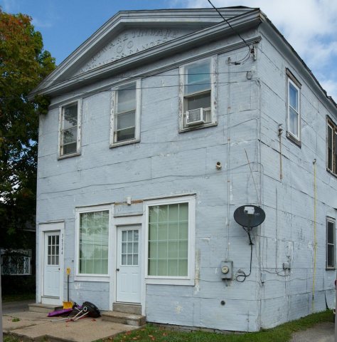
The Irwin Brothers Store and Stone Mills Union Church are listed on the National Register of Historic Places.
In 1806, according to Wikipedia’s history of the town. Orleans’ post office opened in 1822, and the census of 1830 counted 3,101 people here.
How does Orleans rank for history?
Orleans is more historic than 98% of U.S. towns, #56 of 758 in New York. The History grade combines the town’s founding era, the share of homes built before 1940 and its National Register listings. It’s a character grade, so it isn’t part of the overall grade. How it works.
What is on the National Register in Orleans?
20 listings: 19 buildings, among them the Stone Mills Union Church (listed 1976, the first), and 1 historic district, the Thousand Island Park Historic District, with 294 contributing buildings. 340 historic buildings in all.
How old are the homes in Orleans?
38% of Orleans’ homes were built before 1940 (Census estimate, ±5.6 points), against a typical 27% for a New York town; the median home was built in 1970.
Founding dates: Wikidata, Wikipedia, the U.S. post office records of Blevins & Helbock (CC0) and the Census. Homes by year built: Census ACS 2020–24. National Register of Historic Places: National Park Service (list of May 22, 2026). Old photos, postcards and papers: Wikimedia Commons, the Library of Congress and other public archives, credited on each item’s page. Maps: U.S. Geological Survey historical topographic maps (via Esri) and Sanborn fire-insurance maps (Library of Congress). History text and census tables: Wikipedia (CC BY-SA 4.0). Places that used to be: USGS Geographic Names Information System (2021).
From Wikimedia Commons (8), Wikidata (2), the National Register of Historic Places (20), Wikipedia, Wikidata and Wikipedia for famous people, U.S. Geological Survey historical maps, U.S. Census counts (via Wikipedia), the US Post Offices dataset (Blevins & Helbock) and the USGS Geographic Names Information System. Archive images are copied here with their credits and licenses, shown on each photo’s page. Refreshed monthly.


 2018
 2018
 2018
 2018
 2018
 2011
 2007


