Clarkson dates to 1819, and 19% of its homes were built before 1940
More historic than 88% of U.S. towns · #301 of 758 in New York. What drives it
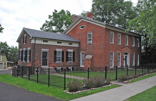
1 place in town is on the National Register, among them a historic district with 67 buildings. Below: 13 old photos and papers, maps from 1899 on, and the census since 1820.
Founding year: Wikidata. First post office: 1820.The full story ↓
History grade
What drives Clarkson’s History grade
On its age, its old homes and the National Register, Clarkson is more historic than 88% of U.S. towns, #301 of 758 in New York. All 3 inputs are above most U.S. towns; its National Register listings ranks highest and its share of homes from before 1940 lowest.
A
HistoryA character grade: shown, never part of Clarkson’s overall grade.
New York towns list more on the Register than most of the country (a typical New York town has 12.3 per 10,000 residents, the U.S. 2.4), so Clarkson’s 98.4 sits above most of its state (76% of New York towns have fewer) while its 67 historic buildings outnumber those of 87% of U.S. towns.
How sure. Graded on any two of the three inputs instead, the letter would still be A−. The pre-1940 share is a Census survey estimate (±7.9 points). Two sources give 1819.
Founding year: Wikidata (other dates in Quick answers). Homes: Census ACS 2020–24. National Register: National Park Service, May 2026 list; each listing counted once (boundary changes and added documentation belong to their listing), and a historic district counts its contributing buildings. How TownRatings grades history →
What stands out about Clarkson’s past
Read from the archive, the National Register and the record. The page puts what stands out first.
National Park Service, National Register of Historic Places. Photos from Wikimedia Commons, credited on each place’s page.
Places that used to be
Lost post offices, old corners, places now gone and burying grounds
Clarkson’s post office has been open since 1820. Two other post offices opened and closed inside today’s town.
Clarkson
1820–today
Redman's Corners
1858–1859
Garland
1887–1901
18201920today
Hamlets and corners on the map
Clarkson Mobile Home ParkGarlandGreenridge Mobile Home ParkOtisRedman Corners
Gone or out of use
Clarkson District Number 2 Public SchoolschoolPara-Tech AirportairportSchool Number 4schoolSchool Number 7schoolSchool Number 8schoolSchool Number 9school
2cemeteries and burying grounds inside Clarkson
GarlandWest Clarkson
US Post Offices dataset (Blevins & Helbock, CC0). Places and cemeteries from the USGS Geographic Names Information System (2021).
Matthew Clarkson was an extensive landowner in this locality, who gave 100 acres (40 ha) to the town. Clarkson was formed from the town of Murray on April 2, 1819. Clarkson was reduced to form the town of Union (the present town of Hamlin) in 1852.
Passages that mention Clarkson, cut from the printed page as they were published.
History of the pioneer settlement of Phelps and Gorham's purchase, and Morris' reserve1851 · page 562Read the page →
Read the text
When I came to Clarkson, in 1815, the Ridge road was but little travelled for want of bridges; my first load of goods broke most of the bridges down from Rochester to Clarkson, and the team was obliged to return to Lima via the south road and Le Roy. That road had been opened before
Text read by machine from the scan; it may contain errors.
History of Rochester and Monroe county, New York1908 · page 1416Read the page →
Read the text
being one of the owners of the D. S. Morgan office building, at the corner of Niagara and Pearl streets in Buffalo, and also owner of two valuable farming properties in the town of Clarkson. He
Text read by machine from the scan; it may contain errors.
History of Rochester and Monroe county, New York1908 · page 1337Read the page →
Read the text
oped a large clientage. He is one of Monroe county's native sons, having been born in Clarkson, August 28, 1840. His father, Garrett Smith, was also a native of Clarkson, while the grandfather, Aaron G. Smith, was a native of New Jersey. The great-grandfather, Garrett Smith, was of Holland Dutch stock and was either born on this side of the water or was brought to Amer-
Text read by machine from the scan; it may contain errors.
History of the pioneer settlement of Phelps and Gorham's purchase, and Morris' reserve1851 · page 559Read the page →
Read the text
When I moved into tlie country in 1811, with my family, we were ferried over the Genesee river at Rochester; the Ridge road was only cut out wide enough for a wagon track; the streams were crossed by means of loobridges. Upon the present site of Clarkson village, there were three log-houses; and in all, perhaps, thirty acres of land cleared. _ James Sayre was the Pioneer of the locality; in fact, the first settler on Ridge, in what is now Clarkson and Murray, and I think, Parma. He had selected this spot on account of a fine spring, before any thing was known of a continu-
Text read by machine from the scan; it may contain errors.
Scans and text from the Internet Archive. Books published in 1930 or earlier, which are in the public domain.
Timeline
Clarkson, 1819 to 2020
Woven from the archive, old maps, post office records, the National Register and the people born here.
Nothing in the archives for these yearsWeddings on Main Street, storms, parades, school pictures, the old store. If it’s in your family album, it belongs here.
In 1819, according to Wikidata. Clarkson’s post office opened in 1820, and the census of 1820 counted 1,612 people here.
How does Clarkson rank for history?
Clarkson is more historic than 88% of U.S. towns, #301 of 758 in New York. The History grade combines the town’s founding era, the share of homes built before 1940 and its National Register listings. It’s a character grade, so it isn’t part of the overall grade. How it works.
What is on the National Register in Clarkson?
One place: the Clarkson Corners Historic District (listed 1994).
How old are the homes in Clarkson?
19% of Clarkson’s homes were built before 1940 (Census estimate, ±7.9 points), against a typical 27% for a New York town; the median home was built in 1988.
Founding dates: Wikidata, Wikipedia, the U.S. post office records of Blevins & Helbock (CC0) and the Census. Homes by year built: Census ACS 2020–24. National Register of Historic Places: National Park Service (list of May 22, 2026). Old photos, postcards and papers: Wikimedia Commons, the Library of Congress and other public archives, credited on each item’s page. Maps: U.S. Geological Survey historical topographic maps (via Esri) and Sanborn fire-insurance maps (Library of Congress). History text and census tables: Wikipedia (CC BY-SA 4.0). Places that used to be: USGS Geographic Names Information System (2021).
From Wikimedia Commons (18), the National Register of Historic Places (1), Wikipedia, Wikidata and Wikipedia for famous people, U.S. Geological Survey historical maps, U.S. Census counts (via Wikipedia), the US Post Offices dataset (Blevins & Helbock), the USGS Geographic Names Information System and old county and town histories (Internet Archive). Archive images are copied here with their credits and licenses, shown on each photo’s page. Refreshed monthly.




 1933
 Date?
 Date?
 Date?
 Date?
 Date?
 Date?
 Date?
 Date?
 Date?
 Date?
 Date?
 2018
 2018
 2012
 2008
 2008


