Founding year: Wikipedia. First post office: 1812.The full story ↓
History grade
What drives Parma’s History grade
On its age, its old homes and the National Register, Parma is more historic than 66% of U.S. towns, #556 of 758 in New York. Its age holds the grade up; its share of homes from before 1940 pulls it down.
B+
HistoryA character grade: shown, never part of Parma’s overall grade.
New York towns list more on the Register than most of the country (a typical New York town has 12.3 per 10,000 residents, the U.S. 2.4), so Parma’s 4.3 sits below most of its state (33% of New York towns have fewer) while its 7 historic buildings outnumber those of 73% of U.S. towns.
How sure. Graded on any two of the three inputs instead, the letter would range from B− to B+. The pre-1940 share (±2.5 points) is firm at this size. Two sources give 1808.
Founding year: Wikipedia (other dates in Quick answers). Homes: Census ACS 2020–24. National Register: National Park Service, May 2026 list; each listing counted once (boundary changes and added documentation belong to their listing), and a historic district counts its contributing buildings. How TownRatings grades history →
What stands out about Parma’s past
Read from the archive, the National Register and the record. The page puts what stands out first.
Lost post offices, old corners, places now gone and burying grounds
Parma had its own post office from 1812 to 1905. Three other post offices opened and closed inside today’s town.
Parma
1812–1905
Parma Centre
1831–1905
West Greece
1844–1900
North Parma
1851–1896
Hilton
1896–today
18101920today
Hamlets and corners on the map
Bartlett CornersCatfieldCollamerDavison BeachHiltonHinkleyvilleLighthouse BeachParma CenterParma CornersSeptember Place Mobile Home ParkWautoma BeachWest Greece
Gone or out of use
Braddock Point LighthousebuildingSchool Number 10schoolSchool Number 10schoolSchool Number 11schoolSchool Number 12schoolSchool Number 14schoolSchool Number 2schoolSchool Number 5schoolSchool Number 6schoolSchool Number 7schoolSchool Number 8schoolSchool Number 9school
8cemeteries and burying grounds inside Parma
Atchinson Family PioneerCastle Family PioneerHoosic Hill PioneerParma CornersParma UnionSmith Family PioneerTyler PioneerWright Family Pioneer
US Post Offices dataset (Blevins & Helbock, CC0). Places and cemeteries from the USGS Geographic Names Information System (2021).
Help out
Start Parma’s collection
The first neighbors to add old photos shape how Parma’s history is told.
Decades since 1900 with photos
00s10s20s30s40s50s60s70s80s90s
0 of 10 decades. The empty ones are waiting for someone’s album.
The town of Parma was established on April 8, 1808, in what was then Genesee County, from the town of Northampton. The new town was named after the city of Parma in Italy.
Passages that mention Parma, cut from the printed page as they were published.
History of the pioneer settlement of Phelps and Gorham's purchase, and Morris' reserve1851 · page 513Read the page →
Read the text
When our family came in, there was but one road leading from the Ridge Road to the Lake ; it was called the " Canawaugus Road ;" another road led from Braddock's Bay to "Deep Hollow Bridge." What was called the Canawaugus road is nosv the main road from Parma Corners to Parma Centre and Unionville. The inhabitants at that period north cf Ridge, in Parma, other than those in the immediate Braddock's Bay settlement, were: — Alpheus Madden, near Parma Centre; died here, his family removed; Timothy Madden, a httle west of Castle's Corners; died 15 or 20
Text read by machine from the scan; it may contain errors.
History of Rochester and Monroe county, New York1908 · page 770Read the page →
Read the text
The grandfather, William Goodell, came to the Town of Parma when it was largely an undeveloped wilderness and at the land office filed his claim to one hundred and eight acres of virgin soil. This tract was covered with its native growth of timber in the midst of the forest he cleared and developed his farm, cutting away the trees, grubbing out the stumps and preparing the
Text read by machine from the scan; it may contain errors.
History of Rochester and Monroe county, New York1908 · page 724Read the page →
Read the text
Oreb T. Hnbbell, who is engaged in the implement business in Spencerport, was born in the town of Parma, this county, March 9, 1844, and is a representative of old New England families, being a son of William and Caroline (Tliorp) Hubbell, who were natives of Berkshire county, Massachusetts, in which locality they were reared and married. Thoy arrived in the town of Parma about
Text read by machine from the scan; it may contain errors.
Scans and text from the Internet Archive. Books published in 1930 or earlier, which are in the public domain.
Timeline
Parma, 1808 to 1905
Woven from the archive, old maps, post office records, the National Register and the people born here.
In 1808, according to Wikipedia’s history of the town. Parma’s post office opened in 1812, and the census of 1820 counted 1,342 people here.
How does Parma rank for history?
Parma is more historic than 66% of U.S. towns, #556 of 758 in New York. The History grade combines the town’s founding era, the share of homes built before 1940 and its National Register listings. It’s a character grade, so it isn’t part of the overall grade. How it works.
What is on the National Register in Parma?
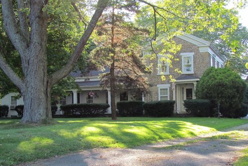
Two places: the Chase Cobblestone Farmhouse (listed 1995) and the Curtis-Crumb Farm (1997).
How old are the homes in Parma?
11% of Parma’s homes were built before 1940 (Census estimate, ±2.5 points), against a typical 27% for a New York town; the median home was built in 1976.
Founding dates: Wikidata, Wikipedia, the U.S. post office records of Blevins & Helbock (CC0) and the Census. Homes by year built: Census ACS 2020–24. National Register of Historic Places: National Park Service (list of May 22, 2026). Old photos, postcards and papers: Wikimedia Commons, the Library of Congress and other public archives, credited on each item’s page. Maps: U.S. Geological Survey historical topographic maps (via Esri) and Sanborn fire-insurance maps (Library of Congress). History text and census tables: Wikipedia (CC BY-SA 4.0). Places that used to be: USGS Geographic Names Information System (2021).
From Wikimedia Commons (5), the National Register of Historic Places (2), Wikipedia, Wikidata and Wikipedia for famous people, U.S. Geological Survey historical maps, U.S. Census counts (via Wikipedia), the US Post Offices dataset (Blevins & Helbock), the USGS Geographic Names Information System and old county and town histories (Internet Archive). Archive images are copied here with their credits and licenses, shown on each photo’s page. Refreshed monthly.


 2022
 2020
 2018
 2018
 2010