1 place in town is on the National Register, among them a historic district with 2 buildings. Below: 5 old photos and papers from 1874 on and old-book passages.
On its age, its old homes and the National Register, Livermore is more historic than 59% of U.S. towns. All 2 inputs are above most U.S. towns; its share of homes from before 1940 ranks highest and its National Register listings lowest.
B
HistoryA character grade: shown, never part of Livermore’s overall grade.
Maine towns list more on the Register than most of the country (a typical Maine town has 15.9 per 10,000 residents, the U.S. 2.4), so Livermore’s 10.7 sits near the middle of its state (43% of Maine towns have fewer) while its 2 historic buildings outnumber those of 60% of U.S. towns.
How sure. Graded on two of the three inputs, so a change in either one moves the letter more than it would with three. The pre-1940 share is a Census survey estimate (±4.9 points).
Founding year: our sources. Homes: Census ACS 2020–24. National Register: National Park Service, May 2026 list; each listing counted once (boundary changes and added documentation belong to their listing), and a historic district counts its contributing buildings. How TownRatings grades history →
What stands out about Livermore’s past
Read from the archive, the National Register and the record. The page puts what stands out first.
Livermore was incorporated in 1795, the northwestern-most town of Androscoggin County. In 1880, the population was 1,262. In 2010, the population was 2,095. Livermore had originally been a grant from the state of Massachusetts to certain people for services in an expedition, which was against Port Royal. The town was named for Deacon Elijah Livermore, a pioneer settler born in Waltham, Massachusetts. The first two settlers of Livermore are known to be Deacon Ellijah Livermore and Major Thomas Fish. Major Thomas Fish had originally been from Worcester County, Oxford, Massachusetts. Major Thomas Fish went to war in 1775, and he was a Major in the Continental Army. Major Thomas Fish had died on December 20, 1781, in Livermore, Maine. Deacon Ellijah Livermore had arrived in 1779, building the first mill near Long Pond in 1782.
Passages that mention Livermore, cut from the printed page as they were published.
Notes, historical, descriptive, and personal, of Livermore, in Androscoggin (formerly in Oxford) county, Maine ..1874 · page 91Read the page →
Read the text
There is no railroad in Livermore, but the Androscoggin Railroad, now a branch of tlie Maine Central Railroad, extending from Leeds Junction to Farmington, runs upon the East Livermore side of the river the entire length of the former town, and near its eastern boundary. A charter, however, has been obtained for a road to extend from Lewiston, via Auburn, North Auburn, Turner, North Turner, Livermore, Canton, and Dixfield, to Rumford Falls. This road, as far at least as Livermore, is likely to be built at an early
Text read by machine from the scan; it may contain errors.
History of Androscoggin County, Maine ..1891 · page 584Read the page →
Read the text
K '' ^ LL that part of the town of Livermore in the county of Oxford on the east side of tlie Androscoggin river " was set off March 20, 1843, and incorporated into the town of East Livermore and classed in the county of Kennebec. The set-off was made on account of the inconvenience of holding town meetings and doing town business across an unbridged river at all seasons of the year. As town meetings were held on the west side of the river at Livermore Center, many a time in March the annual meeting could
Text read by machine from the scan; it may contain errors.
History of Androscoggin County, Maine ..1891 · page 862Read the page →
Read the text
The northeast corner of Livermore is developing extensive business, and the village of Livermore Falls is crowding across the bridge into this town. The Umbagog Pulp Co. has this season built a large brick mill on the site of its old mill to produce 50 tons of pulp where it made only 30 in the old one.
Text read by machine from the scan; it may contain errors.
Scans and text from the Internet Archive. Books published in 1930 or earlier, which are in the public domain.
Timeline
Livermore, 1816 to 1980
Woven from the archive, old maps, post office records, the National Register and the people born here.
Nothing in the archives for these yearsWeddings on Main Street, storms, parades, school pictures, the old store. If it’s in your family album, it belongs here.
Nothing in the archives for these yearsWeddings on Main Street, storms, parades, school pictures, the old store. If it’s in your family album, it belongs here.
Livermore is more historic than 59% of U.S. towns. The History grade combines the town’s founding era, the share of homes built before 1940 and its National Register listings. It’s a character grade, so it isn’t part of the overall grade. How it works.
What is on the National Register in Livermore?
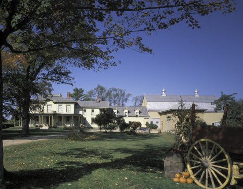
One place: the Nelson Family Farm (listed 1992).
How old are the homes in Livermore?
14% of Livermore’s homes were built before 1940 (Census estimate, ±4.9 points), against a typical 19% for a Maine town; the median home was built in 1971.
Founding dates: Wikidata, Wikipedia, the U.S. post office records of Blevins & Helbock (CC0) and the Census. Homes by year built: Census ACS 2020–24. National Register of Historic Places: National Park Service (list of May 22, 2026). Old photos, postcards and papers: Wikimedia Commons, the Library of Congress and other public archives, credited on each item’s page. Maps: U.S. Geological Survey historical topographic maps (via Esri) and Sanborn fire-insurance maps (Library of Congress). History text and census tables: Wikipedia (CC BY-SA 4.0). Places that used to be: USGS Geographic Names Information System (2021).
From Wikimedia Commons (6), the National Register of Historic Places (1), Wikipedia, Wikidata and Wikipedia for famous people, the US Post Offices dataset (Blevins & Helbock), the USGS Geographic Names Information System and old county and town histories (Internet Archive). Archive images are copied here with their credits and licenses, shown on each photo’s page. Refreshed monthly.


 1874
 1874
 2008