The Canton post office opened in 1821, the earliest record of the town by name. Four smaller post offices, Jay Point (1817), Canton Point (1864) and Gilbertville (1881), opened inside today’s town and later closed.
First census: 746 in 18302020 census: 1,125205 years
How historic is Canton?
B
More historic than 64% of U.S. towns, on its age, its old homes and the National Register.
Founding year: the first Canton post office (Blevins & Helbock, CC0).The full story ↓
History grade
What drives Canton’s History grade
On its age, its old homes and the National Register, Canton is more historic than 64% of U.S. towns. Its share of homes from before 1940 holds the grade up; its National Register listings pull it down.
B
HistoryA character grade: shown, never part of Canton’s overall grade.
Maine towns list more on the Register than most of the country (a typical Maine town has 15.9 per 10,000 residents, the U.S. 2.4), so Canton’s 0.0 sits below most of its state (10% of Maine towns have fewer) while its 0 listings outnumber those of 23% of U.S. towns.
How sure. Graded on any two of the three inputs instead, the letter would range from C+ to A. The pre-1940 share is a Census survey estimate (±10.4 points). The founding year is the first post office, not a stated founding date.
Founding year: the first post office (other dates in Quick answers). Homes: Census ACS 2020–24. National Register: National Park Service, May 2026 list; each listing counted once (boundary changes and added documentation belong to their listing), and a historic district counts its contributing buildings. How TownRatings grades history →
What stands out about Canton’s past
Read from the archive, the National Register and the record. The page puts what stands out first.
Lost post offices, old corners and burying grounds
Canton’s post office has been open since 1821. Four other post offices opened and closed inside today’s town.
Jay Point
1817–1821
Canton
1821–today
Canton Point
1864–1940
Gilbertville
1881–1933
Meadowview
1902–1909
18101920today
Hamlets and corners on the map
Canton PointGilbertvilleMeadowview
6cemeteries and burying grounds inside Canton
Alden HillCantonHillsideLuddenMeadowview RoadPine Grove
US Post Offices dataset (Blevins & Helbock, CC0). Places and cemeteries from the USGS Geographic Names Information System (2021).
Every building
Canton, building by building, 1886–1912
Fire insurance maps drew every building, what it was made of and what it was used for, so insurers could price the risk of fire. Pick a year, then a sheet.
1886Sheet 1 of 1
Edition
Sheets
BrickWoodStone
Sanborn Map Company, via the Library of Congress. Editions published in 1930 or earlier, which are in the public domain.
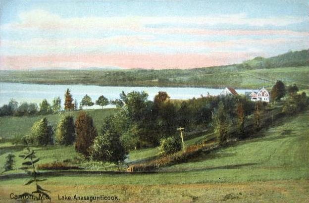
Canton Point was the site of Rockemeka, village of the Anasagunticook (or Androscoggin) Abenaki Indians. It is said the tribe had 500 acres (2.0 km2) cleared to raise corn. In 1698 a French Jesuit mission was established, which they called Naurakamig. By 1757 the tribe population was devastated by smallpox.
The land became part of a grant the Massachusetts General Court awarded to Captain Joseph Phipps and 63 other soldiers for their services during the French and Indian War. Called Phipps-Canada, it was incorporated in 1795 as Jay in honor of John Jay, the first chief justice of the U. S. Supreme Court. On February 5, 1821, Canton was set off from Jay and incorporated, named after Canton, Massachusetts.
Passages that mention Canton, cut from the printed page as they were published.
A history of Buckfield, Oxford County, Maine, from the earliest explorations to the close of the year 19001915 · page 449Read the page →
Read the text
road to Canton Point was completed. And if the land damages claimed between "Corliss Mills and Canton Mills" were satisfied and $45,000 of the ''donation notes" were made cash or payment within six months guaranteed, he would obligate himself to complete and run the road to Canton Alills Village within the year. This appeal met with no response, and Smith housed the rolling stock at Buckfield, closed the stations and retired from all management of the affairs of the road. Snnth having become
Text read by machine from the scan; it may contain errors.
History of Bethel, formerly Sudbury, Canada, Oxford County, Maine, 1768-18901891 · page 16Read the page →
Read the text
took the names of the captains under which they served, while still others had no special designation. Turner was called Sylvester Canada, in honor of Captain Sylvester, while Jay, which once included the present town of Canton, was called Pl-ips Canada, in honor of Captain David Phips. Livermore was granted for services at Port Koyal, and Port Royal was the plantation name of the place.
Text read by machine from the scan; it may contain errors.
A history of Buckfield, Oxford County, Maine, from the earliest explorations to the close of the year 19001915 · page 451Read the page →
Read the text
others, a charter was obtained from the Legislature in March, 1874. for a railroad from the city of Auburn to Alechanic Falls and thence over the road bed of the Portland & Oxford Central Railroad Company to Canton, and up the Androscoggm river valley to Rumford Falls. This was the skillful work of Hon. George D. Bisbee, and the charter was granted for the manifest abuses of the rights and duties of that company toward the public and its neglect to operate the road and keep it in repair.
Text read by machine from the scan; it may contain errors.
History of Rumford, Oxford County, Maine, from its first settlement in 1779, to the present time1890 · page 101Read the page →
Read the text
M HE Indians had villages and places of burial in the town of S^ Bethel, the town next above Rumford, and in the town of Canton below, but there is no evidence going to show that they had either in Rumford. That they were often here and spent more or less time here, there is every reason to believe. Arrow heads and spear heads, gouges, chisels, tomahawks and other rude implements all wrought in stone, were frequently found by the early settlers, and are still occasionally unearthed. It is much to be regretted
Text read by machine from the scan; it may contain errors.
Scans and text from the Internet Archive. Books published in 1930 or earlier, which are in the public domain.
Timeline
Canton, 1817 to 1961
Woven from the archive, old maps, post office records, the National Register and the people born here.
Nothing in the archives for these yearsWeddings on Main Street, storms, parades, school pictures, the old store. If it’s in your family album, it belongs here.
The Canton post office opened in 1821, the earliest record of the town by name (U.S. post office records).
How does Canton rank for history?
Canton is more historic than 64% of U.S. towns. The History grade combines the town’s founding era, the share of homes built before 1940 and its National Register listings. It’s a character grade, so it isn’t part of the overall grade. How it works.
How old are the homes in Canton?
28% of Canton’s homes were built before 1940 (Census estimate, ±10.4 points), against a typical 19% for a Maine town; the median home was built in 1975.
Founding dates: Wikidata, Wikipedia, the U.S. post office records of Blevins & Helbock (CC0) and the Census. Homes by year built: Census ACS 2020–24. National Register of Historic Places: National Park Service (list of May 22, 2026). Old photos, postcards and papers: Wikimedia Commons, the Library of Congress and other public archives, credited on each item’s page. Maps: U.S. Geological Survey historical topographic maps (via Esri) and Sanborn fire-insurance maps (Library of Congress). History text and census tables: Wikipedia (CC BY-SA 4.0). Places that used to be: USGS Geographic Names Information System (2021).
From Wikimedia Commons (12), Wikipedia, Wikidata and Wikipedia for famous people, U.S. Geological Survey historical maps, U.S. Census counts (via Wikipedia), the US Post Offices dataset (Blevins & Helbock), the USGS Geographic Names Information System, Sanborn fire insurance maps (Library of Congress) and old county and town histories (Internet Archive). Archive images are copied here with their credits and licenses, shown on each photo’s page. Refreshed monthly.




 2012
 2012
 2012
 2012
 2012
 2012
 2012
 2012
 2012
 2012


