Stoughton dates to 1713, and 17% of its homes were built before 1940
More historic than 76% of U.S. towns · #239 of 283 in Massachusetts. What drives it
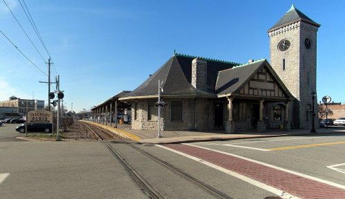
Its Register listings are the Stoughton Railroad Station, the Cobb's Tavern and the Clapp, Lucius, Memorial. Below: 7 old photos and papers, maps from 1885 on, and the census since 1790.
Stoughton dates its founding to 1713 (Wikidata and Wikipedia’s history agree). It appears in the first U.S. census, 1790.
First census: 1,994 in 17902020 census: 29,281313 years
How did Stoughton get its name?
Stoughton was named after William Stoughton, who was the first chief justice of the Colonial Courts, and the most relentless and recalcitrant judge during Salem Witch Trials, who refused to acknowledge the trials were anything but successful and was infuriated when they were ended by Governor Phips.
How historic is Stoughton?
A−
More historic than 76% of U.S. towns, on its age, its old homes and the National Register.
Founding year: Wikidata; Wikipedia’s history section gives the same year. First post office: 1814. Name: Wikipedia, licensed CC BY-SA 4.0.The full story ↓
History grade
What drives Stoughton’s History grade
On its age, its old homes and the National Register, Stoughton is more historic than 76% of U.S. towns, #239 of 283 in Massachusetts. Its age holds the grade up; its National Register listings pull it down.
A−
HistoryA character grade: shown, never part of Stoughton’s overall grade.
Massachusetts towns list more on the Register than most of the country (a typical Massachusetts town has 46.0 per 10,000 residents, the U.S. 2.4), so Stoughton’s 1.0 sits below most of its state (8% of Massachusetts towns have fewer) while its 3 listings outnumber those of 65% of U.S. towns.
How sure. Graded on any two of the three inputs instead, the letter would range from B− to A. The pre-1940 share (±2.7 points) is firm at this size. Two sources give 1713.
Founding year: Wikidata (other dates in Quick answers). Homes: Census ACS 2020–24. National Register: National Park Service, May 2026 list; each listing counted once (boundary changes and added documentation belong to their listing), and a historic district counts its contributing buildings. How TownRatings grades history →
What stands out about Stoughton’s past
Read from the archive, the National Register and the record. The page puts what stands out first.
BicknellEvergreenHoly SepulchreMaplewoodPearl Street
US Post Offices dataset (Blevins & Helbock, CC0). Places and cemeteries from the USGS Geographic Names Information System (2021).
Every building
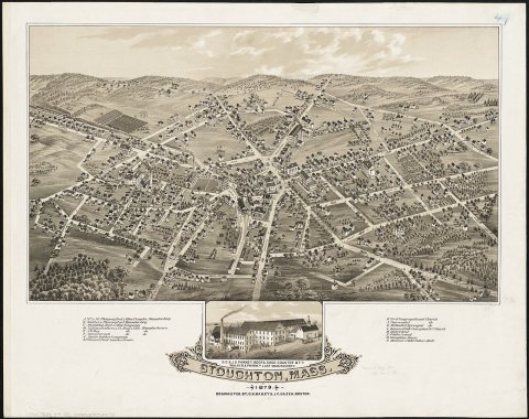
Stoughton, building by building, 1885–1912
Fire insurance maps drew every building, what it was made of and what it was used for, so insurers could price the risk of fire. Pick a year, then a sheet.
Stoughton was settled in 1713, and officially incorporated in 1726 from the southwestern portion of the large town of Dorchester. At its founding, it included the current towns of Sharon (which separated in 1765), Canton (which separated in 1797) and Avon (which separated in 1888). It was named after William Stoughton, who was the first chief justice of the Colonial Courts, and the most relentless and recalcitrant judge during Salem Witch Trials, who refused to acknowledge the trials were anything but successful and was infuriated when they were ended by Governor Phips.
Passages that mention Stoughton, cut from the printed page as they were published.
History of the town of Canton, Norfolk County, Massachusetts1893Read the page →
Read the text
Edward Curtis. Thcophilus Curtis, Nathaniel Hammond, and others residing in that part of Stoughton adjoining Bridgewater, petitioned to be set off to the latter town in 1 74 1. To this the selectmen replied that the land which they represented as worthless, and which they called a "gore," was valuable land; that the school farm of the town of Stoughton was situated in that part of the town, and that the annexation to Bridgewater would not only enrich
Text read by machine from the scan; it may contain errors.
History of Norfolk County, Massachusetts, with biographical sketches of many of its pioneers and prominent men1884 · page 927Read the page →
Read the text
“To the Honourable Senate and House of Representatives of the Com’th of Masstts, in General Court assembled : “The Petition of the Subscribers, Inhabitants of the first Parish in the Town of Stoughton, in the County of Norfolk in s? Comt), humbly showeth that the local situation of said Town of Stoughton is very singular, being near Eleven Miles in length & about four Miles in breadth, as may appear by a Plan thereof, and also that there is a large body of land laying upon
Text read by machine from the scan; it may contain errors.
History of Norfolk County, Massachusetts, 1622-19181918Read the page →
Read the text
"To the Honourable Senate and House of Representatives of the Com'th of Mass'tts, in General Court asembled: "The Petition of the Subscribers, Inhabitants of the first Parish in the Town of Stoughton, in the County of Norfolk in said Com'th, humbly showeth that the local situation of said Town of Stoughton is very singular, being near eleven miles in length & about four Miles in breadth, as may appear by a Plan thereof, and also that there is a large body of land laying upon and contiguous to the line between the North and South Parishes, which is and always will be incapable of
Text read by machine from the scan; it may contain errors.
History of Norfolk County, Massachusetts, 1622-19181918Read the page →
Read the text
EVOLUTION OF STOUGHTON On December 15, 171 5, the region embracing the present Town of Stoughton, and some of the adjacent towns, was organized as the "Dorchester South Precinct." Part of this precinct was set off to Wrentham in 1724, and on December 22, 1726, the territory now embraced in the towns of Canton, Sharon, Stoughton and the greater part of Foxboro was incorporated as a town by the name of Stoughton, taking its name from Gov. William Stoughton. On July 2, 1740, by an act of the General Court, that part now included in Foxboro and
Text read by machine from the scan; it may contain errors.
Scans and text from the Internet Archive. Books published in 1930 or earlier, which are in the public domain.
Timeline
Stoughton, 1713 to 1968
Woven from the archive, old maps, post office records, the National Register and the people born here.
Nothing in the archives for these yearsWeddings on Main Street, storms, parades, school pictures, the old store. If it’s in your family album, it belongs here.
In 1713, according to Wikidata and Wikipedia’s history of the town. Stoughton’s post office opened in 1814, and the first U.S. census counted 1,994 people here in 1790.
How does Stoughton rank for history?
Stoughton is more historic than 76% of U.S. towns, #239 of 283 in Massachusetts. The History grade combines the town’s founding era, the share of homes built before 1940 and its National Register listings. It’s a character grade, so it isn’t part of the overall grade. How it works.
What is on the National Register in Stoughton?
Three places: the Stoughton Railroad Station (listed 1974), the Cobb's Tavern (1974) and the Clapp, Lucius, Memorial (1992).
How old are the homes in Stoughton?
17% of Stoughton’s homes were built before 1940 (Census estimate, ±2.7 points), against a typical 21% for a Massachusetts town; the median home was built in 1969.
Founding dates: Wikidata, Wikipedia, the U.S. post office records of Blevins & Helbock (CC0) and the Census. Homes by year built: Census ACS 2020–24. National Register of Historic Places: National Park Service (list of May 22, 2026). Old photos, postcards and papers: Wikimedia Commons, the Library of Congress and other public archives, credited on each item’s page. Maps: U.S. Geological Survey historical topographic maps (via Esri) and Sanborn fire-insurance maps (Library of Congress). History text and census tables: Wikipedia (CC BY-SA 4.0). Places that used to be: USGS Geographic Names Information System (2021).
From Wikimedia Commons (12), the National Register of Historic Places (3), Wikipedia, Wikidata and Wikipedia for famous people, U.S. Geological Survey historical maps, U.S. Census counts (via Wikipedia), the US Post Offices dataset (Blevins & Helbock), the USGS Geographic Names Information System, Sanborn fire insurance maps (Library of Congress) and old county and town histories (Internet Archive). Archive images are copied here with their credits and licenses, shown on each photo’s page. Refreshed monthly.


 1939
 2008
 2008
 2008
 2005
 2004