Sterling dates to 1720, and 13% of its homes were built before 1940
More historic than 90% of U.S. towns · #145 of 283 in Massachusetts. What drives it
3 places in town are on the National Register, among them a historic district with 106 buildings. Below: 8 old photos and papers, maps from 1885 on, and the census since 1790.
Founding year: Wikidata. First post office: 1804.The full story ↓
History grade
What drives Sterling’s History grade
On its age, its old homes and the National Register, Sterling is more historic than 90% of U.S. towns, #145 of 283 in Massachusetts. All 3 inputs are above most U.S. towns; its age ranks highest and its share of homes from before 1940 lowest.
A
HistoryA character grade: shown, never part of Sterling’s overall grade.
Massachusetts towns list more on the Register than most of the country (a typical Massachusetts town has 46.0 per 10,000 residents, the U.S. 2.4), so Sterling’s 138 sits above most of its state (69% of Massachusetts towns have fewer) while its 113 historic buildings outnumber those of 90% of U.S. towns.
NoteThe founding year comes from Wikidata alone; no second source gives 1720.
How sure. Graded on any two of the three inputs instead, the letter would range from A− to A+. The pre-1940 share is a Census survey estimate (±6.8 points).
Founding year: Wikidata (other dates in Quick answers). Homes: Census ACS 2020–24. National Register: National Park Service, May 2026 list; each listing counted once (boundary changes and added documentation belong to their listing), and a historic district counts its contributing buildings. How TownRatings grades history →
What stands out about Sterling’s past
Read from the archive, the National Register and the record. The page puts what stands out first.
Previous to its incorporation, it was "the Second Parish of Lancaster." It was commonly called by a portion of its Indian name, Chocksett. There was an Indian fort and graveyard located between East Waushacum Pond and West Waushacum Pond. Sagamore Sam, a Nashaway sachem and insurgent during King Philip's War, was from Waushacum.
The Nipmuc minister, Peter Jethro, worked in the area in the 1670s. The original Indian name of the area was Woonsechocksett. The land encompassing the Chocksett region was not originally included in the first land sold by the great Indian Chief Sholan to the settlers of the Lancaster grant. However, Sholan's nephew Tahanto would eventually sell the Chocksett land to the inhabitants of Lancaster in 1713.
Passages that mention Sterling, cut from the printed page as they were published.
History of Grafton, Worcester county, Massachusetts, from its early settlement by the Indians in 1647 to the present time, 1879. Including the genealogies of seventy-nine of the older families1879Read the page →
Read the text
t This strip of land was united to Lancaster Second Parish, by an act of incorporation, February, 1768. In 1781 tliis parish was incorporated into a town, by the name of Sterling. In 1796 certain inhabitants of Boylston, Sterling"and Holden, formed themsilves together into a precinct, and in 1808 they obtained an act of incorporation by the name of West Boylston.
Text read by machine from the scan; it may contain errors.
History of Grafton, Worcester county, Massachusetts, from its early settlement by the Indians in 1647 to the present time, 1879. Including the genealogies of seventy-nine of the older families1879Read the page →
Read the text
try from England, whose preaching excited a great deal of entliusiasm, and was the occasion of much controversy among the clergy, and of many unhappy divisions in the *It was adopted by the First Church in Sterling in 1744, and by the Northborough Church in 1746, as we learn from Rev. Mr. Allen's Centennial Discourse; and by the First Church in Worcester, with some slight modifications making it more doctrinal, in 1746, as we learn from Ml'.
Text read by machine from the scan; it may contain errors.
Scans and text from the Internet Archive. Books published in 1930 or earlier, which are in the public domain.
Timeline
Sterling, 1720 to 2020
Woven from the archive, old maps, post office records, the National Register and the people born here.
Nothing in the archives for these yearsWeddings on Main Street, storms, parades, school pictures, the old store. If it’s in your family album, it belongs here.
In 1720, according to Wikidata. Sterling’s post office opened in 1804, and the first U.S. census counted 1,428 people here in 1790.
How does Sterling rank for history?
Sterling is more historic than 90% of U.S. towns, #145 of 283 in Massachusetts. The History grade combines the town’s founding era, the share of homes built before 1940 and its National Register listings. It’s a character grade, so it isn’t part of the overall grade. How it works.
What is on the National Register in Sterling?
Three places: the Sterling Center Historic District (listed 1988), the Sawyer Homestead (2000) and the Stephen Hastings House (2005).
How old are the homes in Sterling?
13% of Sterling’s homes were built before 1940 (Census estimate, ±6.8 points), against a typical 21% for a Massachusetts town; the median home was built in 1980.
Founding dates: Wikidata, Wikipedia, the U.S. post office records of Blevins & Helbock (CC0) and the Census. Homes by year built: Census ACS 2020–24. National Register of Historic Places: National Park Service (list of May 22, 2026). Old photos, postcards and papers: Wikimedia Commons, the Library of Congress and other public archives, credited on each item’s page. Maps: U.S. Geological Survey historical topographic maps (via Esri) and Sanborn fire-insurance maps (Library of Congress). History text and census tables: Wikipedia (CC BY-SA 4.0). Places that used to be: USGS Geographic Names Information System (2021).
From Wikimedia Commons (11), the Library of Congress (1), the National Register of Historic Places (3), Wikipedia, Wikidata and Wikipedia for famous people, U.S. Geological Survey historical maps, U.S. Census counts (via Wikipedia), the US Post Offices dataset (Blevins & Helbock), the USGS Geographic Names Information System and old county and town histories (Internet Archive). Archive images are copied here with their credits and licenses, shown on each photo’s page. Refreshed monthly.


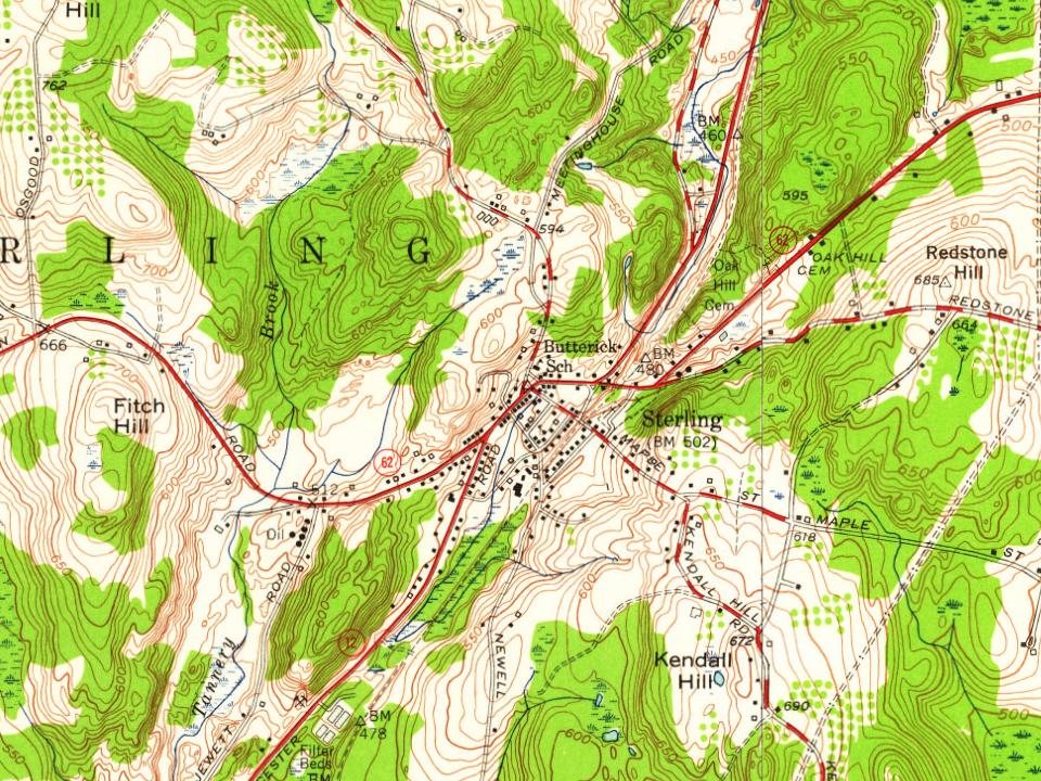


 1899
 1900
 1901
 1903
 2009
 2009
 2007
 2006
