New Britain dates to 1687, and 30% of its homes were built before 1940
More historic than 90% of U.S. towns · #43 of 155 in Connecticut. What drives it
21 places in town are on the National Register, among them five historic districts with 405 buildings between them. Below: 6 old photos and papers, maps from 1884 on, and the census since 1880.
Founding year: Wikipedia. First post office: 1828.The full story ↓
History grade
What drives New Britain’s History grade
On its age, its old homes and the National Register, New Britain is more historic than 90% of U.S. towns, #43 of 155 in Connecticut. All 2 inputs are above most U.S. towns; its share of homes from before 1940 ranks highest and its National Register listings lowest.
A
HistoryA character grade: shown, never part of New Britain’s overall grade.
Connecticut towns list more on the Register than most of the country (a typical Connecticut town has 73.3 per 10,000 residents, the U.S. 2.4), so New Britain’s 57.4 sits near the middle of its state (42% of Connecticut towns have fewer) while its 426 historic buildings outnumber those of 97% of U.S. towns.
NoteThe founding year comes from Wikipedia alone; no second source gives 1687.
How sure. Graded on two of the three inputs, so a change in either one moves the letter more than it would with three. The pre-1940 share (±2.2 points) is firm at this size.
Founding year: Wikipedia (other dates in Quick answers). Homes: Census ACS 2020–24. National Register: National Park Service, May 2026 list; each listing counted once (boundary changes and added documentation belong to their listing), and a historic district counts its contributing buildings. How TownRatings grades history →
What stands out about New Britain’s past
Read from the archive, the National Register and the record. The page puts what stands out first.
New Britain was settled in 1687. It was incorporated as a new parish as the New Britain Society in 1754.
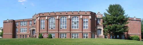
Chartered in 1850 as a township and in 1871 as a city, New Britain had separated from the nearby towns of Farmington and Berlin, Connecticut. A consolidation charter was adopted in 1905. New Britain Normal School trained teachers. It relocated in 1922 to its current location on Stanley Street. It became Teachers College of Connecticut in 1933. It was renamed again in 1959 as Central Connecticut State College and in 1983 became Central Connecticut State University.
Passages that mention New Britain, cut from the printed page as they were published.
History of New Britain, with sketches of Farmington and Berlin, Connecticut. 1640-18891889 · page 411Read the page →
Read the text
the society in 1754. He lived on Clark Hill at the north end of Stanley Quarter. He married, Sept. 2, 1742, Elizabeth Newell, daughter of Capt. John Newell of Parmington, and though living within the present limits of New Britain, and identified with the interests and people of Stanley Quarter, he preferred to retain his connection with the society in Farmington, and he and his farm were specially excepted when the parish of New Britain was incorporated. After
Text read by machine from the scan; it may contain errors.
History of New Britain, with sketches of Farmington and Berlin, Connecticut. 1640-18891889 · page 197Read the page →
Read the text
In 1850 the citizens of Kensington and Worthington petitioned for a division of the town. The petition was granted, Berlin, including the two parishes mentioned, retaining the old name, and the parish of New Britain, by itself, becoming the town of New Britain. The last town meeting before the division of the town was held in Berlin. By the act of the General Assembly, the division line, or boundary, between the two towns begins at
Text read by machine from the scan; it may contain errors.
The memorial history of Hartford County, Connecticut, 1633-18841886 · page 324Read the page →
Read the text
The Assembly accepted the report and passed an act to carry it into effect. Thus Stanley Quarter, as the annexed portion of Farmington was called, became a part of the parish of Newington ; and it so continued till 1754, when the parish of New Britain was incorporated, covering this territory, and Beckley Quarter was confirmed to the society of Kensington, and afterward became incorporated with the town of Berlin. In the year 1716 the new society began to keep a record of its meetings, and from that time to the present this record is
Text read by machine from the scan; it may contain errors.
The story of New Britain, Connecticut1925 · page 66Read the page →
Read the text
During this period, Connecticut, in the process of laying out its town boundaries, changed the parish of New Britain, from Farmington, to Berlin. Instead of being one of half a dozen parishes distant from the town center, the New Britain parish united with those of Worthington and Kensington to make an independent town.
Text read by machine from the scan; it may contain errors.
Scans and text from the Internet Archive. Books published in 1930 or earlier, which are in the public domain.
Timeline
New Britain, 1687 to 1969
Woven from the archive, old maps, post office records, the National Register and the people born here.
Nothing in the archives for these yearsWeddings on Main Street, storms, parades, school pictures, the old store. If it’s in your family album, it belongs here.
Fire insurance maps drew every building, what it was made of and what it was used for, so insurers could price the risk of fire. Pick a year, then a sheet.
New Britain’s post office has been open since 1828.
Hamlets and corners on the map
Corbin Heights HousingMount Pleasant HousingPinnacle Heights Housing
Gone or out of use
New Britain HomebuildingStanley Schoolschool
13cemeteries and burying grounds inside New Britain
AndrewsBeth AlomBeth MishkaFairviewHoly TrinityOld Saint Mary Roman CatholicPolish National CatholicRussian OrthodoxSacred HeartSaint MarysSaint Marys OldSaint Marys Ukrainian OrthodoxSaint Thomas
US Post Offices dataset (Blevins & Helbock, CC0). Places and cemeteries from the USGS Geographic Names Information System (2021).
Help out
Finish New Britain’s story
Most archives stop around 1920. The photos from after that are in family albums, not libraries.
Decades since 1900 with photos
00s10s20s30s40s50s60s70s80s90s
0 of 10 decades. The empty ones are waiting for someone’s album.
In 1687, according to Wikipedia’s history of the town. New Britain’s post office opened in 1828, and the census of 1880 counted 11,800 people here.
How does New Britain rank for history?
New Britain is more historic than 90% of U.S. towns, #43 of 155 in Connecticut. The History grade combines the town’s founding era, the share of homes built before 1940 and its National Register listings. It’s a character grade, so it isn’t part of the overall grade. How it works.
What is on the National Register in New Britain?
21 listings: 15 buildings, 5 historic districts with 405 contributing buildings, and 1 site. 426 historic buildings in all.
How old are the homes in New Britain?
30% of New Britain’s homes were built before 1940 (Census estimate, ±2.2 points), against a typical 15% for a Connecticut town; the median home was built in 1956.
Founding dates: Wikidata, Wikipedia, the U.S. post office records of Blevins & Helbock (CC0) and the Census. Homes by year built: Census ACS 2020–24. National Register of Historic Places: National Park Service (list of May 22, 2026). Old photos, postcards and papers: Wikimedia Commons, the Library of Congress and other public archives, credited on each item’s page. Maps: U.S. Geological Survey historical topographic maps (via Esri) and Sanborn fire-insurance maps (Library of Congress). History text and census tables: Wikipedia (CC BY-SA 4.0). Places that used to be: USGS Geographic Names Information System (2021).
From Wikimedia Commons (6), the National Register of Historic Places (21), Wikipedia, Wikidata and Wikipedia for famous people, U.S. Geological Survey historical maps, U.S. Census counts (via Wikipedia), the US Post Offices dataset (Blevins & Helbock), the USGS Geographic Names Information System, Sanborn fire insurance maps (Library of Congress) and old county and town histories (Internet Archive). Archive images are copied here with their credits and licenses, shown on each photo’s page. Refreshed monthly.




 1879
 1879
 1879
 1879


