The Berry post office opened in 1851, the earliest record of the town by name. Another post office, Marxville (1886), opened inside today’s town and later closed.
2020 census: 1,168175 years
How historic is Berry?
B
More historic than 64% of U.S. towns, on its age, its old homes and the National Register.
Founding year: the first Berry post office (Blevins & Helbock, CC0).The full story ↓
History grade
What drives Berry’s History grade
On its age, its old homes and the National Register, Berry is more historic than 64% of U.S. towns. Its National Register listings hold the grade up; its age pulls it down.
B
HistoryA character grade: shown, never part of Berry’s overall grade.
Wisconsin towns list more on the Register than most of the country (a typical Wisconsin town has 3.0 per 10,000 residents, the U.S. 2.4), so Berry’s 17.8 sits above most of its state (81% of Wisconsin towns have fewer) while its 2 listings outnumber those of 60% of U.S. towns.
How sure. Graded on any two of the three inputs instead, the letter would range from B− to A−. The pre-1940 share is a Census survey estimate (±4.6 points). The founding year is the first post office, not a stated founding date.
Founding year: the first post office (other dates in Quick answers). Homes: Census ACS 2020–24. National Register: National Park Service, May 2026 list; each listing counted once (boundary changes and added documentation belong to their listing), and a historic district counts its contributing buildings. How TownRatings grades history →
What stands out about Berry’s past
Read from the archive, the National Register and the record. The page puts what stands out first.
The Town of Berry was established on January 7, 1850, by being split off from Farmersville. It was probably named for Berry Haney, who kept a tavern in the 1830s and was the first postmaster of the Cross Plains post office in 1838.
Passages that mention Berry, cut from the printed page as they were published.
Madison, Dane County and surrounding towns1877 · page 495Read the page →
Read the text
corner of this county; is bounded on the north by the town of West Point, in Coliinibia couDty, on the east jby the towij of Dane, on the Bouth by the town of Berry, and on the west by the town of Mazomanie and the town of Prairie du Sac, in Sauk county. It is not quite a full township, the Wisconsin river cutting ott* the northwest corner of section six.
Text read by machine from the scan; it may contain errors.
History of Dane County, Wisconsin ... preceded by a history of Wisconsin, statistics of the state, and an abstract of its laws and constitution and of the Constitution of the United States1880 · page 926Read the page →
Read the text
tave Herring giving the land for the cemetery, and making the principle contribution toward paying for the building ; there are about forty families in connection, Charles Schenck being the Pastor; The Catholic Church of the Town of Berry. — The Catholic congregation was organized in 1853, and in that year a log church was built. Before that time, the people were sometimes visited by the Rev. Father Zuorna. On the 29th of October, 1854, Rev. L. Conrad was sent out by the M. R. Bishop as the first Presiding Pastor. The congregation then had twenty-five families. Together with the erection of the church, a Catholic German school was founded,
Text read by machine from the scan; it may contain errors.
Madison, Dane County and surrounding towns1877 · page 273Read the page →
Read the text
conveniences, and perhaps could not be better told than to relate an incident that came imder my own observation. The nearest post-offieo was Madison, and letters for the town of Berry had to come over the Sauk road, by way of Mr. Dunlap's, then sometime afterwards it would be carried from there to Cross Plains, and then to Mr. Thomas, who was postmaster, on section 10. A friend and myself
Text read by machine from the scan; it may contain errors.
A history of Madison, the capital of Wisconsin1874 · page 394Read the page →
Read the text
The Township of Berry is situated in the northwestern portion of the county, and was formerly a part of Springfield. It is known as township 8, north of range 7, east.
Text read by machine from the scan; it may contain errors.
Scans and text from the Internet Archive. Books published in 1930 or earlier, which are in the public domain.
Timeline
Berry, 1851 to 1907
Woven from the archive, old maps, post office records, the National Register and the people born here.
The Berry post office opened in 1851, the earliest record of the town by name (U.S. post office records).
How does Berry rank for history?
Berry is more historic than 64% of U.S. towns. The History grade combines the town’s founding era, the share of homes built before 1940 and its National Register listings. It’s a character grade, so it isn’t part of the overall grade. How it works.
What is on the National Register in Berry?
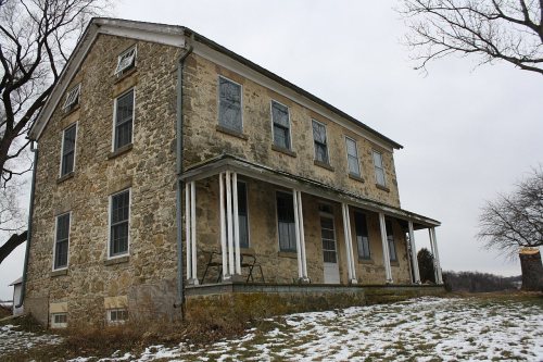
Two places: the Friederich Kohlmann House (listed 1974) and the Frederick Schumann Farmstead (1993).
How old are the homes in Berry?
18% of Berry’s homes were built before 1940 (Census estimate, ±4.6 points), against a typical 12% for a Wisconsin town; the median home was built in 1973.
Founding dates: Wikidata, Wikipedia, the U.S. post office records of Blevins & Helbock (CC0) and the Census. Homes by year built: Census ACS 2020–24. National Register of Historic Places: National Park Service (list of May 22, 2026). Old photos, postcards and papers: Wikimedia Commons, the Library of Congress and other public archives, credited on each item’s page. Maps: U.S. Geological Survey historical topographic maps (via Esri) and Sanborn fire-insurance maps (Library of Congress). History text and census tables: Wikipedia (CC BY-SA 4.0). Places that used to be: USGS Geographic Names Information System (2021).
From Wikimedia Commons (23), Wikidata (1), the National Register of Historic Places (2), Wikipedia, U.S. Geological Survey historical maps, the US Post Offices dataset (Blevins & Helbock), the USGS Geographic Names Information System and old county and town histories (Internet Archive). Archive images are copied here with their credits and licenses, shown on each photo’s page. Refreshed monthly.



 2014
 2013
 2013
 2013
 2013
 2013
 2013
 2013
 2013
 2013
 2013
 2013
 2013
 2013
 2013
 2012
 2012
 2012
 2012
 2012
 2012
 2011
 2004


