Guest, Sign inJoin

Post to Pittsford

We’ll email a one-tap link to publish your post. No password, and nothing is public until you click it.
Already a member? Sign in
AHistory
History · Pittsford

Pittsford dates to 1769, and 21% of its homes were built before 1940

More historic than 91% of U.S. towns · #36 of 71 in Vermont. What drives it

7 places in town are on the National Register. Below: 11 old photos and papers, maps from 1895 on, and the census since 1790.

1769founded
7on the National Register
21%homes built before 1940
11old photos & papers
4famous people
From Pittsford’s archive · credits on each photo
Quick answers

How Pittsford began

When was Pittsford founded?

1769

Pittsford dates its founding to 1769 (Wikipedia’s history). It appears in the first U.S. census, 1790.

First census: 850 in 17902020 census: 2,862257 years

How historic is Pittsford?

A

More historic than 91% of U.S. towns, on its age, its old homes and the National Register.

What drives the grade ↓
Founding year: Wikipedia. First post office: 1808.The full story ↓
History grade

What drives Pittsford’s History grade

On its age, its old homes and the National Register, Pittsford is more historic than 91% of U.S. towns, #36 of 71 in Vermont. All 3 inputs are above most U.S. towns; its age ranks highest and its National Register listings lowest.

A
HistoryA character grade: shown, never part of Pittsford’s overall grade.
All U.S. towns we grade (21,289)Ahead of 91%
NewerOlder
Vermont towns of 2,500+ (71)Ahead of 50%

Vermont towns list more on the Register than most of the country (a typical Vermont town has 147 per 10,000 residents, the U.S. 2.4), so Pittsford’s 83.0 sits near the middle of its state (53% of Vermont towns have fewer) while its 24 historic buildings outnumber those of 80% of U.S. towns.

NoteThe founding year comes from Wikipedia alone; no second source gives 1769.
How sure. Graded on any two of the three inputs instead, the letter would range from A− to A. The pre-1940 share is a Census survey estimate (±8.9 points).

Founding year: Wikipedia (other dates in Quick answers). Homes: Census ACS 2020–24. National Register: National Park Service, May 2026 list; each listing counted once (boundary changes and added documentation belong to their listing), and a historic district counts its contributing buildings. How TownRatings grades history →

What stands out about Pittsford’s past

Read from the archive, the National Register and the record. The page puts what stands out first.

★ What stands out · Places that used to be

Lost post offices, old corners, places now gone and burying grounds

Pittsford’s post office has been open since 1808. Two other post offices opened and closed inside today’s town.

Pittsford
1808–today
Florence
1882–1903
East Pittsford
1886–1901
Florence
1913–today
18001910today
Hamlets and corners on the map
East PittsfordFlorenceGrangerville
Gone or out of use
Caverly Preventoriumhospital
5cemeteries and burying grounds inside Pittsford
Congregational Burial YardEast PittsfordEvergreenOldSaint Alphonsus

US Post Offices dataset (Blevins & Helbock, CC0). Places and cemeteries from the USGS Geographic Names Information System (2021).

On the National Register

7 historic places in Pittsford

The country’s official list of buildings and places worth saving.

places listed
7
National Historic Landmarks
0
none yet
historic buildings protected
24
each building in a district counts
first listed
1974
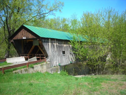
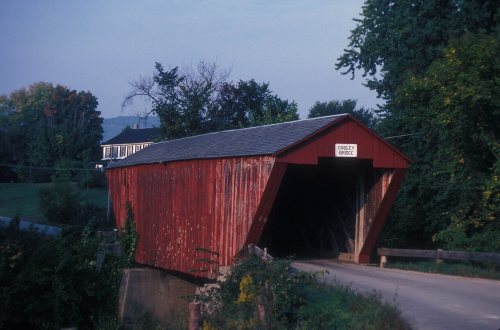
Depot Covered Bridge
BuildingsSitesStructures

Architectural styles listings

Town lattice truss3
Greek Revival2
Italianate Revival1
Federal1
Gothic Revival1
Italianate1
All 7 listings

National Park Service, National Register of Historic Places. Photos from Wikimedia Commons, credited on each place’s page.

Timeline

Pittsford, 1769 to 1941

Woven from the archive, old maps, post office records, the National Register and the people born here.

  1. 18th century
  2. 1769
    FoundingPittsford is established
  3. 1770Born hereCaleb Hopkins is born here
  4. 19th century
  5. 1808Post officeThe Pittsford post office opens
  6. 1812Born hereWilliam Warner is born here
  7. 1832BuiltThomas H. Palmer House is built
  8. 1848In the archiveView in Pittsford, Vermont Frederic Edwin Church
  9. 1872In the archive1872 A plan of the town of Pittsford, taken from Baldwin's original draught of said towns…
  10. 1873Born hereBenjamin Gates is born here
  11. 1881Born hereHilda Belcher is born here
  12. 1882Post officeThe Florence post office opens
  13. 1886Post officeThe East Pittsford post office opens
  14. 1895On the mapFirst mapped by the U.S. Geological Survey
  15. 1896In the archivePittsford Library ca1895 Vermont
  16. 20th century
  17. 1901Post officeThe East Pittsford post office closes
  18. 1903Post officeThe Florence post office closes
  19. 1913In the archiveEast Pittsford Dam
  20. 1941In the archiveCutting hay near Pittsford, Vermont
The story

How Pittsford came to be

From Wikipedia’s history of Pittsford.

Read it all →

Pittsford was first settled as a frontier town in 1769, about 60 miles (97 km) north of Bennington. It is the location of two historical picket forts used by the militia during the American Revolutionary War: Fort Mott (built in 1777), and Fort Vengeance (built from 1780 to 1781), about a mile north.

The town of Pittsford, New York, was named by Colonel Caleb Hopkins after his hometown of Pittsford, Vermont, named after William Pitt.

Text from Wikipedia, licensed CC BY-SA 4.0.

From the old history books

What they wrote about Pittsford, 1882–1886

Passages that mention Pittsford, cut from the printed page as they were published.

Asa Nourse came to Pittsford to reside with his brother Josiah in 1 8 19; he taught school for several seasons. In 1824 he purchased an undivided onehalf of the saw-mill north of the Colburn bridge, and in 1830 he bought of Andrew Leach some land and buildings just east of Leach's blacksmith shop.
History of Rutland County, Vermont, with illustrations and biographical sketches of some of its prominent men and pioneers1886Read the page →
Read the text

Asa Nourse came to Pittsford to reside with his brother Josiah in 1 8 19; he taught school for several seasons. In 1824 he purchased an undivided onehalf of the saw-mill north of the Colburn bridge, and in 1830 he bought of Andrew Leach some land and buildings just east of Leach's blacksmith shop.

Text read by machine from the scan; it may contain errors.
known as the two-story school-house. The history of this district is briefly as follows: Previous to 1836 there was no school district at the falls; the socalled Humphrey farm belonged to District Number 10, while all north of his farm and south of Pittsford was considered a part of the south, or K…
History of Rutland County, Vermont, with illustrations and biographical sketches of some of its prominent men and pioneers1886 · page 451Read the page →
Read the text

known as the two-story school-house. The history of this district is briefly as follows: Previous to 1836 there was no school district at the falls; the socalled Humphrey farm belonged to District Number 10, while all north of his farm and south of Pittsford was considered a part of the south, or Kingsley District of Pittsford. When Moses and Willard Humphrey began business, in 1836, a new district was formed and numbered fourteen, including all of the territory south of the Pittsford line to Joel M. Mead's farm. They began an attempt to secure the erection of a school-house for the new district by sub-

Text read by machine from the scan; it may contain errors.
lie was one of the committee of five, appointed by the proprietors, who laid out the three principal highways through the town, from Pittsford to Leicester, and from Pittsford to Sudbury, which was in November, 1783.
The history of Rutland county, Vermont1882Read the page →
Read the text

lie was one of the committee of five, appointed by the proprietors, who laid out the three principal highways through the town, from Pittsford to Leicester, and from Pittsford to Sudbury, which was in November, 1783.

Text read by machine from the scan; it may contain errors.
He was first on the committee appointed by the proprietors, before the town was organized, to lay out the principal roads " from Pittsford to Leicester, and from Pittsford to Sudbury, on the west side of the Creek, and from Pittsford to the mills, now the village, on the east side of the Creek, (" …
The history of Rutland county, Vermont1882Read the page →
Read the text

He was first on the committee appointed by the proprietors, before the town was organized, to lay out the principal roads " from Pittsford to Leicester, and from Pittsford to Sudbury, on the west side of the Creek, and from Pittsford to the mills, now the village, on the east side of the Creek, (" four rods wide.") He was often appointed to some

Text read by machine from the scan; it may contain errors.

Scans and text from the Internet Archive. Books published in 1930 or earlier, which are in the public domain.

By decade

Pittsford, decade by decade

5 decades in the archive, from the 1840s to the 1940s. Scroll each row; tap a photo for its story.

On the map

Pittsford on the map, 1895 to 1944

Every edition of the U.S. Geological Survey’s map of Pittsford. Tap a year, or press play to watch the town change.

Pittsford on the 1895 USGS mapPittsford on the 1944 USGS map1895Castleton sheet · 1:62,500

U.S. Geological Survey historical topographic maps (public domain), via Esri’s collection of the scans. The red ring marks the center of Pittsford.

Then & now

Stand where they stood

No then-and-now pairs yet. Take a photo from the same spot as an old one and they appear here side by side.

View in Pittsford, Vermont Frederic Edwin Church
Retake this viewView in Pittsford, Vermont Frederic Edwin Church, 1848

Find the spot, match the angle, and add your photo. It becomes the first then-and-now pair on Pittsford’s page.

Retake this view · +15
People over time

Pittsford, census by census

05001,0001,5002,0002,5003,0003,50018001850190019502000Peak: 3,140

Between 850 and 3,140 people in every census since 1790.

24 censuses, 1790–2020.

U.S. Census Bureau decennial counts, from the census table on Pittsford’s Wikipedia page.

Famous people

4 famous people were born in Pittsford

Writers, athletes, leaders and more, ranked by how widely they’re known.

See all →
Help out

Finish Pittsford’s story

Most archives stop around 1920. The photos from after that are in family albums, not libraries.

Decades since 1900 with photos
00s10s20s30s40s50s60s70s80s90s
2 of 10 decades. The empty ones are waiting for someone’s album.
Stories next door

History across the town line

Each neighbor’s History grade, on the same three inputs.

Questions about Pittsford’s history

What year was Pittsford founded?

In 1769, according to Wikipedia’s history of the town. Pittsford’s post office opened in 1808, and the first U.S. census counted 850 people here in 1790.

How does Pittsford rank for history?

Pittsford is more historic than 91% of U.S. towns, #36 of 71 in Vermont. The History grade combines the town’s founding era, the share of homes built before 1940 and its National Register listings. It’s a character grade, so it isn’t part of the overall grade. How it works.

What is on the National Register in Pittsford?

7 listings: 2 buildings, 1 site, and 4 structures. 24 historic buildings in all.

How old are the homes in Pittsford?

21% of Pittsford’s homes were built before 1940 (Census estimate, ±8.9 points), against a typical 22% for a Vermont town; the median home was built in 1972.

Memory lane

What the archives can’t tell you, neighbors can.

Town Square →
Start a conversation
Sources

Where this page comes from

Founding dates: Wikidata, Wikipedia, the U.S. post office records of Blevins & Helbock (CC0) and the Census. Homes by year built: Census ACS 2020–24. National Register of Historic Places: National Park Service (list of May 22, 2026). Old photos, postcards and papers: Wikimedia Commons, the Library of Congress and other public archives, credited on each item’s page. Maps: U.S. Geological Survey historical topographic maps (via Esri) and Sanborn fire-insurance maps (Library of Congress). History text and census tables: Wikipedia (CC BY-SA 4.0). Places that used to be: USGS Geographic Names Information System (2021).

From Wikimedia Commons (6), the Library of Congress (5), Wikidata (1), the National Register of Historic Places (7), Wikipedia, Wikidata and Wikipedia for famous people, U.S. Geological Survey historical maps, U.S. Census counts (via Wikipedia), the US Post Offices dataset (Blevins & Helbock), the USGS Geographic Names Information System and old county and town histories (Internet Archive). Archive images are copied here with their credits and licenses, shown on each photo’s page. Refreshed monthly.