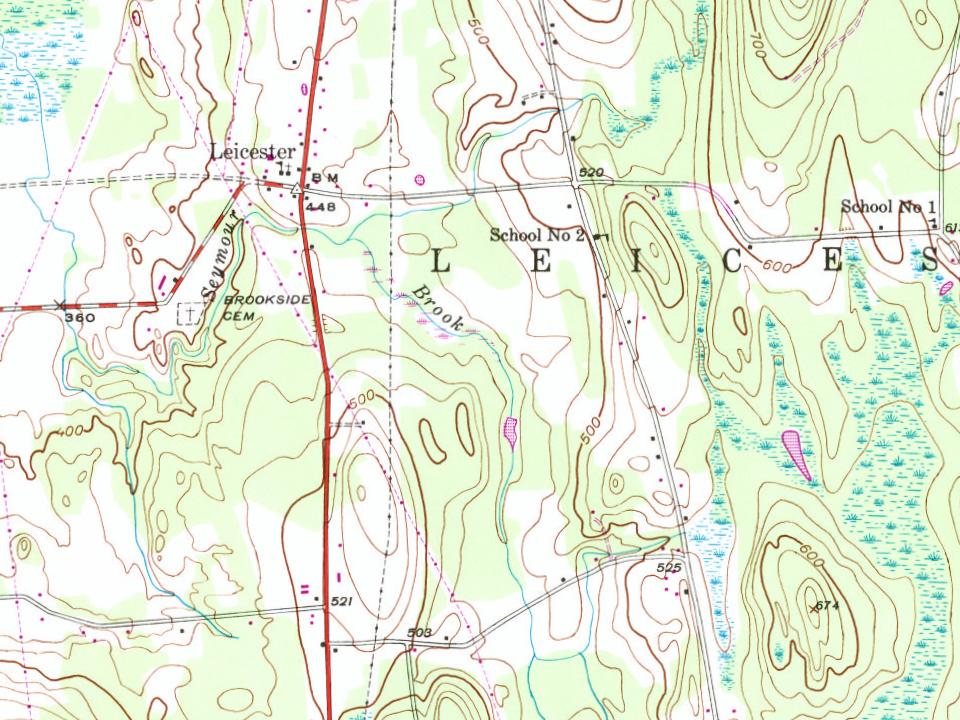
Its Register listings are the Stagecoach Inn, the School House and Town Hall and the Leicester Meeting House. Below: maps from 1902 on and the census since 1790.
On its age, its old homes and the National Register, Leicester is more historic than 86% of U.S. towns. All 3 inputs are above most U.S. towns; its age ranks highest and its National Register listings lowest.
A
HistoryA character grade: shown, never part of Leicester’s overall grade.
Vermont towns list more on the Register than most of the country (a typical Vermont town has 147 per 10,000 residents, the U.S. 2.4), so Leicester’s 29.2 sits near the middle of its state (40% of Vermont towns have fewer) while its 3 listings outnumber those of 65% of U.S. towns.
NoteThe founding year comes from Wikidata alone; no second source gives 1761.
How sure. Graded on any two of the three inputs instead, the letter would range from B+ to A. The pre-1940 share is a Census survey estimate (±5.9 points).
Founding year: Wikidata (other dates in Quick answers). Homes: Census ACS 2020–24. National Register: National Park Service, May 2026 list; each listing counted once (boundary changes and added documentation belong to their listing), and a historic district counts its contributing buildings. How TownRatings grades history →
What stands out about Leicester’s past
Read from the archive, the National Register and the record. The page puts what stands out first.
Lost a third of its people between 1860 and 1920, then more than doubled.
24 censuses, 1790–2020.
U.S. Census Bureau decennial counts, from the census table on Leicester’s Wikipedia page.
Places that used to be
Lost post offices, old corners and burying grounds
Three other post offices opened and closed inside today’s town.
Leichester
1823–1903
Leichester Junction
1872–1988
Fernville
1892–1895
18201920today
Hamlets and corners on the map
FernvilleLeicester JunctionSatans KingdomTowtaid
1cemetery inside Leicester
Brookside
US Post Offices dataset (Blevins & Helbock, CC0). Places and cemeteries from the USGS Geographic Names Information System (2021).
The story so far
Leicester, in brief
Wikipedia doesn’t have a history of Leicester yet. The photos, dates and memories neighbors add here are how it gets written.
Leicester ( LEST-ər) is a town in Addison County, Vermont, United States. The population was 990 at the 2020 census.
Leicester was established in 1761. Between the 2010 and 2020 censuses its population fell from 1,100 to 990 (-10%).
Intro from Wikipedia. Population: U.S. Census Bureau.
From the old history books
What they wrote about Leicester in 1886
Passages that mention Leicester, cut from the printed page as they were published.
History of Addison county Vermont, with illustrations and biographical sketches of some of its prominent men and pioneers1886 · page 596Read the page →
Read the text
When the town of Leicester was chartered it was intended that it should have an equal extent of territory with Salisbury ; but after Brandon to the south, and Middlebury on the north, had been Laid out, it was discovered that only about eight miles of distance were left for the twoytowns of Leicester and Salisbury, or four miles for each, instead of six. This state of affairs led to a great deal of difficulty, which continued until April, 1796, when a committee was chosen to adjust the matter, consisting of John Smith, Benjamin Garfield, and Joseph Woodward, of Leicester, and Eleazer Claghorn, Salathiel Bump,
Text read by machine from the scan; it may contain errors.
History of Addison county Vermont, with illustrations and biographical sketches of some of its prominent men and pioneers1886 · page 66Read the page →
Read the text
tlement on the borders of the lake in Addison in 1765, and took possession with their families in 1766.1 .... A few other families were settled there before the struggle for independence began. The first settlements, by families, in Whiting and Leicester, were in 1773 ; in Cornwall and Monkton in 1774; in Weybridge in 1775. In no other towns in the county had permanent settlements been made at that time ; and in the towns mentioned the number of families was small."2 On the 19th of April, 1775, the first blood of the Revolution was shed at
Text read by machine from the scan; it may contain errors.
Scans and text from the Internet Archive. Books published in 1930 or earlier, which are in the public domain.
Timeline
Leicester, 1761 to 2010
Woven from the archive, old maps, post office records, the National Register and the people born here.
In 1761, according to Wikidata. Leicester’s post office opened in 1823, and the first U.S. census counted 343 people here in 1790.
How does Leicester rank for history?
Leicester is more historic than 86% of U.S. towns. The History grade combines the town’s founding era, the share of homes built before 1940 and its National Register listings. It’s a character grade, so it isn’t part of the overall grade. How it works.
What is on the National Register in Leicester?
Three places: the Stagecoach Inn (listed 1984), the School House and Town Hall (1988) and the Leicester Meeting House (1988).
How old are the homes in Leicester?
21% of Leicester’s homes were built before 1940 (Census estimate, ±5.9 points), against a typical 22% for a Vermont town; the median home was built in 1981.
Founding dates: Wikidata, Wikipedia, the U.S. post office records of Blevins & Helbock (CC0) and the Census. Homes by year built: Census ACS 2020–24. National Register of Historic Places: National Park Service (list of May 22, 2026). Old photos, postcards and papers: Wikimedia Commons, the Library of Congress and other public archives, credited on each item’s page. Maps: U.S. Geological Survey historical topographic maps (via Esri) and Sanborn fire-insurance maps (Library of Congress). History text and census tables: Wikipedia (CC BY-SA 4.0). Places that used to be: USGS Geographic Names Information System (2021).
From Wikimedia Commons (4), Wikidata (1), the National Register of Historic Places (3), Wikidata and Wikipedia for famous people, U.S. Geological Survey historical maps, U.S. Census counts (via Wikipedia), the US Post Offices dataset (Blevins & Helbock), the USGS Geographic Names Information System and old county and town histories (Internet Archive). Archive images are copied here with their credits and licenses, shown on each photo’s page. Refreshed monthly.


 2016
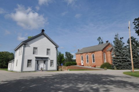 2016
 2004
 2003