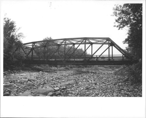
6 places in town are on the National Register, among them a historic district with 4 buildings. Below: 4 old photos and papers, maps from 1891 on, and the census since 1790.
The Clarendon post office opened in 1816, the earliest record of the town by name. Four smaller post offices, East Clarendon (1831), Clarendon Springs (1837) and Chippenhook Springs (1869), opened inside today’s town and later closed.
First census: 1,478 in 17902020 census: 2,412210 years
How historic is Clarendon?
A−
More historic than 80% of U.S. towns, on its age, its old homes and the National Register.
Founding year: the first Clarendon post office (Blevins & Helbock, CC0).The full story ↓
History grade
What drives Clarendon’s History grade
On its age, its old homes and the National Register, Clarendon is more historic than 80% of U.S. towns. All 3 inputs are above most U.S. towns; its age ranks highest and its National Register listings lowest.
A−
HistoryA character grade: shown, never part of Clarendon’s overall grade.
Vermont towns list more on the Register than most of the country (a typical Vermont town has 147 per 10,000 residents, the U.S. 2.4), so Clarendon’s 28.5 sits near the middle of its state (39% of Vermont towns have fewer) while its 7 historic buildings outnumber those of 73% of U.S. towns.
How sure. Graded on any two of the three inputs instead, the letter would range from B+ to A−. The pre-1940 share is a Census survey estimate (±7.2 points). The founding year is the first post office, not a stated founding date.
Founding year: the first post office (other dates in Quick answers). Homes: Census ACS 2020–24. National Register: National Park Service, May 2026 list; each listing counted once (boundary changes and added documentation belong to their listing), and a historic district counts its contributing buildings. How TownRatings grades history →
What stands out about Clarendon’s past
Read from the archive, the National Register and the record. The page puts what stands out first.
The area that later formed the Town of Clarendon was settled by families from lower New England as early as 1762. It and the surrounding area was then part of Albany County, New York, but was later split off as Charlotte County until Vermont declared itself as a republic around 1777. Land claims by New Hampshire were eventually settled, and in 1791 Vermont became a state.
Clarendon now includes the following entries on the National Register of Historic Places:
Brown Covered Bridge – bridges the Cold River on Cold River Road in North Clarendon. NOTE: The Brown Covered Bridge is actually on the Upper Cold River Road in Shrewsbury and was damaged during the flooding from Hurricane Irene (added February 21, 1974)
of the hill, adjacent to the town of Ira, believing it for their interests, because they could with less travel get to the business centre of Ira than to that of Clarendon, petitioned the legislature, and, in 1854, were set off to and made a part of that town : so, through the cupidity of some, and for the convenience of others, the town of Clarendon
Text read by machine from the scan; it may contain errors.
Jacob Marsh of Clarendon, alluded to above, purchased of James Duane, William Ccckburn and 16 other New York grantees of Socialborough a tract of land the deed of which is dated Jan. 9. 1772. The tract contained 600 acres and was included in the grant of Socialborough and lies mostly within the present limits of the town of Claren-
Text read by machine from the scan; it may contain errors.
History of Rutland County, Vermont, with illustrations and biographical sketches of some of its prominent men and pioneers1886Read the page →
Read the text
When he reached twenty years of age his father died, leaving a considerable estate, the princiijal part of which consisted of two farms in the town of Clarendon, one of them being on the hill near Clarendon Springs. The son was deemed the best person to settle the estate and accordingly he was appointed administrator. His father's family consisted of his wife (who was Laura Spring before her marriage, daughter of .Amos Spring, of Clarendon), and four children ; the eldest was EHzabeth, who married Moses W. Kelly, a farmer of Clarendon ; ne.xt was Porter; the third, Willis, who now lives in Wallingford ; and Eliza, married A. Jay Newton, a farmer of Clarendon. The settlement of the estate was executed by the son
Text read by machine from the scan; it may contain errors.
History of Rutland County, Vermont, with illustrations and biographical sketches of some of its prominent men and pioneers1886 · page 555Read the page →
Read the text
achusetts, in 1744. In 1760 Lydius divided the tract (on paper) into thirtyfive townships of thirtysix square miles each, or more, numbering and giving names to each township. No. 7, which is supposed t3 be nearly identical with the present town of Clarendon, he called "Durham." September 29, 1761, he granted about twenty-seven square miles, covering a part of Rutland and Clarendon, to James Haven, who leased farm lots to the settlers for the rent of one pepper-corn a year for the first twenty years and 5s. a year thereafter, for each one hundred acres of improvable land.
Text read by machine from the scan; it may contain errors.
Scans and text from the Internet Archive. Books published in 1930 or earlier, which are in the public domain.
Timeline
Clarendon, 1789 to 1990
Woven from the archive, old maps, post office records, the National Register and the people born here.
Nothing in the archives for these yearsWeddings on Main Street, storms, parades, school pictures, the old store. If it’s in your family album, it belongs here.
The Clarendon post office opened in 1816, the earliest record of the town by name (U.S. post office records).
How does Clarendon rank for history?
Clarendon is more historic than 80% of U.S. towns. The History grade combines the town’s founding era, the share of homes built before 1940 and its National Register listings. It’s a character grade, so it isn’t part of the overall grade. How it works.
What is on the National Register in Clarendon?
6 listings: 3 buildings, 1 historic district, the Kingsley Grist Mill Historic District, with 4 contributing buildings, and 2 structures. 7 historic buildings in all.
How old are the homes in Clarendon?
22% of Clarendon’s homes were built before 1940 (Census estimate, ±7.2 points), against a typical 22% for a Vermont town; the median home was built in 1971.
Founding dates: Wikidata, Wikipedia, the U.S. post office records of Blevins & Helbock (CC0) and the Census. Homes by year built: Census ACS 2020–24. National Register of Historic Places: National Park Service (list of May 22, 2026). Old photos, postcards and papers: Wikimedia Commons, the Library of Congress and other public archives, credited on each item’s page. Maps: U.S. Geological Survey historical topographic maps (via Esri) and Sanborn fire-insurance maps (Library of Congress). History text and census tables: Wikipedia (CC BY-SA 4.0). Places that used to be: USGS Geographic Names Information System (2021).
From Wikimedia Commons (9), Wikidata (2), the National Register of Historic Places (6), Wikipedia, Wikidata and Wikipedia for famous people, U.S. Geological Survey historical maps, U.S. Census counts (via Wikipedia), the US Post Offices dataset (Blevins & Helbock), the USGS Geographic Names Information System and old county and town histories (Internet Archive). Archive images are copied here with their credits and licenses, shown on each photo’s page. Refreshed monthly.


 c. 1868
 Date?
 2017
 2017
 2017
 2006
 2004