Guest, Sign inJoin

Post to Burlington

We’ll email a one-tap link to publish your post. No password, and nothing is public until you click it.
Already a member? Sign in
A+History
History · Burlington

Burlington dates to 1783, and 38% of its homes were built before 1940

More historic than 96% of U.S. towns · #21 of 71 in Vermont. What drives it

52 places in town are on the National Register, among them ten historic districts with 983 buildings between them. Below: 18 old photos and papers, maps from 1885 on, and the census since 1790.

1783founded
52on the National Register
38%homes built before 1940
18old photos & papers
55famous people
From Burlington’s archive · credits on each photo
Quick answers

How Burlington began

When was Burlington founded?

1783

Burlington dates its founding to 1783 (Wikidata). It appears in the first U.S. census, 1790.

First census: 330 in 17902020 census: 44,743243 years

How historic is Burlington?

A+

More historic than 96% of U.S. towns, on its age, its old homes and the National Register.

What drives the grade ↓
Founding year: Wikidata. First post office: 1792.The full story ↓
History grade

What drives Burlington’s History grade

On its age, its old homes and the National Register, Burlington is more historic than 96% of U.S. towns, #21 of 71 in Vermont. All 3 inputs are above most U.S. towns; its share of homes from before 1940 ranks highest and its age lowest.

A+
HistoryA character grade: shown, never part of Burlington’s overall grade.
All U.S. towns we grade (21,289)Ahead of 96%
NewerOlder
Vermont towns of 2,500+ (71)Ahead of 71%

Vermont towns list more on the Register than most of the country (a typical Vermont town has 147 per 10,000 residents, the U.S. 2.4), so Burlington’s 230 sits above most of its state (73% of Vermont towns have fewer) while its 1,026 historic buildings outnumber those of 99% of U.S. towns.

NoteThe founding year comes from Wikidata alone; no second source gives 1783.
How sure. Graded on any two of the three inputs instead, the letter would range from A to A+. The pre-1940 share (±2.8 points) is firm at this size.

Founding year: Wikidata (other dates in Quick answers). Homes: Census ACS 2020–24. National Register: National Park Service, May 2026 list; each listing counted once (boundary changes and added documentation belong to their listing), and a historic district counts its contributing buildings. How TownRatings grades history →

What stands out about Burlington’s past

Read from the archive, the National Register and the record. The page puts what stands out first.

★ What stands out · On the National Register

52 listings protect 1,026 historic buildings

The country’s official list of buildings and places worth saving. Boundary changes and added documentation are counted with their listing.

places listed
52
National Historic Landmarks
0
none yet
historic buildings protected
1,026
each building in a district counts
first listed
1971
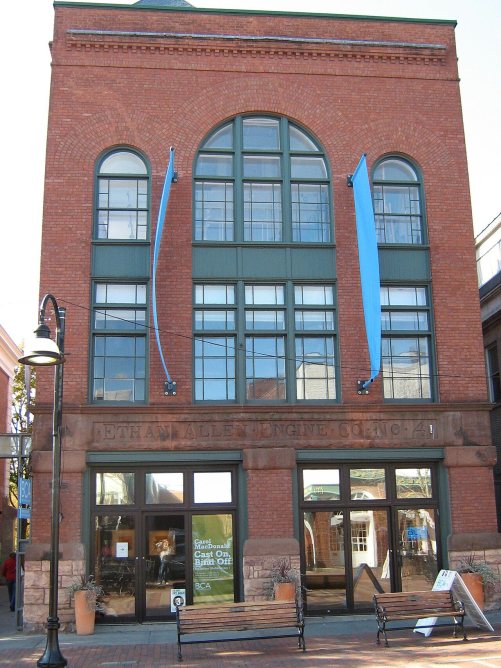
Ethan Allen Engine company No. 4
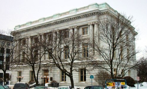
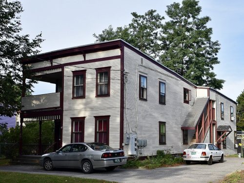
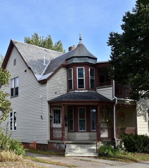
Ethan Allen Engine company No. 4Follett HouseU.S. Post Office and CustomhouseGrassemountWinterbotham EstateCarnegie Building of the Fletcher Free LibraryBattery Street Historic DistrictOld Ohavi Zedek SynagogueFirst Methodist Church of BurlingtonWells-Richardson DistrictEdward Wells HouseLakeside DevelopmentDaniel Webster Robinson HouseChamplain SchoolWells-Jackson Carriage House ComplexMartin L. Kelsey HouseCity Hall Park Historic DistrictPearl Street Historic DistrictEthan Allen HomesteadMain Street-College Street Historic DistrictSouth Union Street Historic DistrictBurlington Montgomery Ward BuildingBuell Street-Bradley Street Historic DistrictMoquin's BakeryHoward Mortuary ChapelFirst Baptist ChurchSaltus Grocery Store, built 1897North Street Historic DistrictBurlington BreakwaterBurlington Traction CompanyRobarge, John B. DuplexCharles R. Palmer HouseLucy Ruggles HouseLeFarriere House, built 1888Mintzer House, built 1898Normand House, built 1869House at 44 Front Street, built 1892Church Street Historic District, built 1981Moran Municipal Generation Station, built 1955William Fitzgerald BlockApartment Building at 27 and 31 Peru Street and 29 Johnson Street, built 1889Roberge-Desautels Apartment House, built 1900Head of Church Street Historic DistrictSouth Willard Street Historic DistrictRedstone Historic DistrictWinooski Falls Mill Historic DistrictGENERAL BUTLER (shipwreck)O.J. WALKER (shipwreck)Duplex at 22-26 Johnson StreetDuplex at 73-75 Sherman StreetStannard House, built 1850Converse Hall
BuildingsDistrictsSitesStructures

Architectural styles listings

Italianate16
Queen Anne15
Colonial Revival14
Greek Revival11
Federal9
Vernacular7
All 52 listings
First Methodist Church of BurlingtonBuilding · listed 1978Wells-Richardson DistrictDistrict · listed 1979Edward Wells HouseBuilding · listed 1979Lakeside DevelopmentDistrict · listed 1982Daniel Webster Robinson HouseBuilding · listed 1982Champlain SchoolBuilding · listed 1982Wells-Jackson Carriage House ComplexBuilding · listed 1982Martin L. Kelsey HouseBuilding · listed 1983City Hall Park Historic DistrictDistrict · listed 1983Pearl Street Historic DistrictDistrict · listed 1984Ethan Allen HomesteadBuilding · listed 1986Main Street-College Street Historic DistrictDistrict · listed 1988South Union Street Historic DistrictDistrict · listed 1988Burlington Montgomery Ward BuildingBuilding · listed 1991Buell Street-Bradley Street Historic DistrictDistrict · listed 1995Moquin's BakeryBuilding · listed 1997Howard Mortuary ChapelBuilding · listed 1999First Baptist ChurchBuilding · listed 2001Saltus Grocery StoreBuilding · listed 2001North Street Historic DistrictDistrict · listed 2001Burlington BreakwaterStructure · listed 2003Burlington Traction CompanyBuilding · listed 2004Robarge, John B. DuplexBuilding · listed 2005Charles R. Palmer HouseBuilding · listed 2005Lucy Ruggles HouseBuilding · listed 2005LeFarriere HouseBuilding · listed 2008Mintzer HouseBuilding · listed 2008Normand HouseBuilding · listed 2008House at 44 Front StreetBuilding · listed 2008Church Street Historic DistrictDistrict · listed 2010Moran Municipal Generation StationBuilding · listed 2010William Fitzgerald BlockBuilding · listed 2012Apartment Building at 27 and 31 Peru Street and 29 Johnson StreetBuilding · listed 2014Roberge-Desautels Apartment HouseBuilding · listed 2014Head of Church Street Historic DistrictDistrict · listed 1974South Willard Street Historic DistrictDistrict · listed 1988Redstone Historic DistrictDistrict · listed 1991Winooski Falls Mill Historic DistrictDistrict · listed 1993GENERAL BUTLER (shipwreck)Site · listed 1998O.J. WALKER (shipwreck)Site · listed 1998Duplex at 22-26 Johnson StreetBuilding · listed 2012Duplex at 73-75 Sherman StreetBuilding · listed 2013Stannard HouseBuilding · listed 2019Converse HallBuilding · listed 2021

National Park Service, National Register of Historic Places. Photos from Wikimedia Commons, credited on each place’s page.

Every building

Burlington, building by building, 1885–1926

Fire insurance maps drew every building, what it was made of and what it was used for, so insurers could price the risk of fire. Pick a year, then a sheet.

Burlington fire insurance map, 1885, sheet 11885Sheet 1 of 15
Edition
BrickWoodStone

Sanborn Map Company, via the Library of Congress. Editions published in 1930 or earlier, which are in the public domain.

The story

How Burlington came to be

From Wikipedia’s history of Burlington.

Read it all →

King George II of Great Britain placed the western border of the Province of New Hampshire twenty miles (32 km) east of the Hudson River. However, George III moved the Province of New York's border to the Connecticut River. He stated that the land claims of those currently in the area gained by New York were still valid, but New York courts ruled against the settlers. New Hampshire Governor Benning Wentworth continued to sell land in these areas in direct opposition to New York and royal demands. On June 7, 1763, the grant document for Burlington was awarded to Samuel Willis and 63 others. In the summer of 1775, settlers began clearing the land and built two or three log huts in 1775, but the outbreak of the American Revolutionary War delayed permanent settlement until after its conclusion. The first recorded town meeting was held on March 19, 1787.

Text from Wikipedia, licensed CC BY-SA 4.0.

From the old history books

What they wrote about Burlington in 1886

Passages that mention Burlington, cut from the printed page as they were published.

this act was amended and the right given to the company to construct its road " from some point in Highgate, on the Canada line, thence through the village of St. Albans to some point or points in Chittenden county, most convenient for meeting at the village of Burlington, a railroad to be built on…
History of Chittenden County, Vermont, with illustrations and biographical sketches of some of its prominent men and pioneers1886 · page 191Read the page →
Read the text

this act was amended and the right given to the company to construct its road " from some point in Highgate, on the Canada line, thence through the village of St. Albans to some point or points in Chittenden county, most convenient for meeting at the village of Burlington, a railroad to be built on the route described in the acts to incorporate the Champlain and Connecticut River Railroad Company, and the Vermont Central Railroad Company." The route determined upon extends from Rouse's Point to Burlington, through Colchester, Milton, Georgia, St. Albans, Swanton and Alburgh, a distance of fifty-three

Text read by machine from the scan; it may contain errors.
The Bank of Burlington. — After the removal of the Burlington branch of the Vermont State Bank to Woodstock, in 181 2, the residents of Chittenden county felt the necessity of an establishment of the kind here, and in 1816, through their agency, application was made to the Legislature for another b…
History of Chittenden County, Vermont, with illustrations and biographical sketches of some of its prominent men and pioneers1886 · page 452Read the page →
Read the text

The Bank of Burlington. — After the removal of the Burlington branch of the Vermont State Bank to Woodstock, in 181 2, the residents of Chittenden county felt the necessity of an establishment of the kind here, and in 1816, through their agency, application was made to the Legislature for another branch at Burlington ; but nothing was accomplished until November 9, 1 8 18, when the Bank of Burlington was incorporated. We have not been able to procure all the information which we wished in regard to this institution. It wielded a most beneficent influence in the entire State for nearly half

Text read by machine from the scan; it may contain errors.

Scans and text from the Internet Archive. Books published in 1930 or earlier, which are in the public domain.

Timeline

Burlington, 1783 to 1976

Woven from the archive, old maps, post office records, the National Register and the people born here.

  1. 18th century
  2. 1783
    FoundingBurlington is established
  3. 1792Post officeThe Burlington post office opens
  4. 1798In the archiveBTV partialParcelMap 1798
  5. 19th century
  6. 1800In the archiveGrasseMountDuringBarnes 1800s
  7. 1850In the archivePlan of the city of Burlington shewing (i.e. showing) water & sewer service
  8. 1859Born hereJohn Dewey is born here
  9. 1860In the archiveBurlington Railroad Tunnel, Leading Southwest Towards Burlington Harbor
  10. 1869BuiltNormand House is built
  11. 1879Born hereGrace Coolidge is born here
  12. 1886In the archiveBook Room, Billings Memorial Library, University of Vermont
  13. 1888BuiltLeFarriere House is built
  14. 1890In the archiveGardener's Cottage, Redstone estate, Burlington VT designed by Marling & Burdett Architec…
  15. 1897BuiltSaltus Grocery Store is built
  16. 1898BuiltMintzer House is built
  17. 20th century
  18. 1906On the mapFirst mapped by the U.S. Geological Survey
  19. 1973Born hereTana French is born here
  20. 1976Born hereJake Sullivan is born here
By decade

Burlington, decade by decade

7 decades in the archive, from the 1790s to the 1900s. Scroll each row; tap a photo for its story.

On the map

Burlington on the map, 1906 to 1987

Every edition of the U.S. Geological Survey’s map of Burlington. Tap a year, or press play to watch the town change.

Burlington on the 1906 USGS mapBurlington on the 1919 USGS mapBurlington on the 1948 USGS mapBurlington on the 1972 USGS mapBurlington on the 1987 USGS map1906Burlington sheet · 1:62,500

U.S. Geological Survey historical topographic maps (public domain), via Esri’s collection of the scans. The red ring marks the center of Burlington.

Then & now

Stand where they stood

No then-and-now pairs yet. Take a photo from the same spot as an old one and they appear here side by side.

"Burlington, Vt. 1858. From the Lake."
Retake this view"Burlington, Vt. 1858. From the Lake.", 1858

Find the spot, match the angle, and add your photo. It becomes the first then-and-now pair on Burlington’s page.

Retake this view · +15
People over time

Burlington, census by census

05,00010,00015,00020,00025,00030,00035,00040,00045,00050,0001800185019001950200044,743

Grew from 330 people in 1790 to 44,743 in 2020, more than tenfold.

24 censuses, 1790–2020.

U.S. Census Bureau decennial counts, from the census table on Burlington’s Wikipedia page.

Famous people

55 famous people were born in Burlington

Writers, athletes, leaders and more, ranked by how widely they’re known.

See all →
Places that used to be

Old corners, places now gone and burying grounds

Burlington’s post office has been open since 1792.

Hamlets and corners on the map
Bernard J Leddy ParkCatlinsburgOakledge ParkRedstone ParkStarr Farm Beach
Gone or out of use
District School Number 8schoolFairholt AirportairportFirst Methodist Episcopal Baptist ChurchchurchIra Allen Schoolschool
9cemeteries and burying grounds inside Burlington
Elmwood AvenueEpiscopal DioceseGreenmountGreenmountLakeviewMount CalvaryMount CalvaryOhavi ZedekSaint Joseph

US Post Offices dataset (Blevins & Helbock, CC0). Places and cemeteries from the USGS Geographic Names Information System (2021).

Help out

Finish Burlington’s story

Most archives stop around 1920. The photos from after that are in family albums, not libraries.

Decades since 1900 with photos
00s10s20s30s40s50s60s70s80s90s
1 of 10 decades. The empty ones are waiting for someone’s album.
Stories next door

History across the town line

Each neighbor’s History grade, on the same three inputs.

Questions about Burlington’s history

What year was Burlington founded?

In 1783, according to Wikidata. Burlington’s post office opened in 1792, and the first U.S. census counted 330 people here in 1790.

How does Burlington rank for history?

Burlington is more historic than 96% of U.S. towns, #21 of 71 in Vermont. The History grade combines the town’s founding era, the share of homes built before 1940 and its National Register listings. It’s a character grade, so it isn’t part of the overall grade. How it works.

What is on the National Register in Burlington?

52 listings: 35 buildings, among them the Ethan Allen Engine company No. 4 (listed 1971, the first), 14 historic districts with 983 contributing buildings, 2 sites, and 1 structure. 1,026 historic buildings in all.

How old are the homes in Burlington?

38% of Burlington’s homes were built before 1940 (Census estimate, ±2.8 points), against a typical 22% for a Vermont town; the median home was built in 1957.

Memory lane

What the archives can’t tell you, neighbors can.

Town Square →
Start a conversation
Sources

Where this page comes from

Founding dates: Wikidata, Wikipedia, the U.S. post office records of Blevins & Helbock (CC0) and the Census. Homes by year built: Census ACS 2020–24. National Register of Historic Places: National Park Service (list of May 22, 2026). Old photos, postcards and papers: Wikimedia Commons, the Library of Congress and other public archives, credited on each item’s page. Maps: U.S. Geological Survey historical topographic maps (via Esri) and Sanborn fire-insurance maps (Library of Congress). History text and census tables: Wikipedia (CC BY-SA 4.0). Places that used to be: USGS Geographic Names Information System (2021).

From Wikimedia Commons (13), the Library of Congress (5), Wikidata (5), the National Register of Historic Places (52), Wikipedia, Wikidata and Wikipedia for famous people, U.S. Geological Survey historical maps, U.S. Census counts (via Wikipedia), the US Post Offices dataset (Blevins & Helbock), the USGS Geographic Names Information System, Sanborn fire insurance maps (Library of Congress) and old county and town histories (Internet Archive). Archive images are copied here with their credits and licenses, shown on each photo’s page. Refreshed monthly.