14% of North Kingstown’s homes were built before 1940
More historic than 78% of U.S. towns · #29 of 38 in Rhode Island. What drives it
29 places in town are on the National Register, among them the Gilbert Stuart Birthplace, a National Historic Landmark, and ten historic districts with 321 buildings between them. Below: 4 old photos and papers, maps from 1890 on, and the census since 1790.
On its age, its old homes and the National Register, North Kingstown is more historic than 78% of U.S. towns, #29 of 38 in Rhode Island. All 2 inputs are above most U.S. towns; its National Register listings ranks highest and its share of homes from before 1940 lowest.
A−
HistoryA character grade: shown, never part of North Kingstown’s overall grade.
Rhode Island towns list more on the Register than most of the country (a typical Rhode Island town has 94.7 per 10,000 residents, the U.S. 2.4), so North Kingstown’s 124 sits near the middle of its state (58% of Rhode Island towns have fewer) while its 345 historic buildings outnumber those of 96% of U.S. towns.
How sure. Graded on two of the three inputs, so a change in either one moves the letter more than it would with three. The pre-1940 share (±2.3 points) is firm at this size.
Founding year: our sources. Homes: Census ACS 2020–24. National Register: National Park Service, May 2026 list; each listing counted once (boundary changes and added documentation belong to their listing), and a historic district counts its contributing buildings. How TownRatings grades history →
What stands out about North Kingstown’s past
Read from the archive, the National Register and the record. The page puts what stands out first.
Camp EndicottmilitaryCamp ThomasmilitaryDavis MilllocaleDavisville Naval Construction Battalion CentermilitaryJamestown-Saunderstown FerrylocaleNaval Air Station Quonset PointmilitaryNorth Kingstown Emergency Operations PadairportPoplar Point LighthouselocaleQuonset Point State AirportairportRed SchoolhouseschoolRobbers CornerlocaleRodman MilllocaleSaint Pauls ChurchchurchSlocum Airportairport
80family graveyards and cemeteries inside North Kingstown
Allen - Pierce FarmAustinBenjamin Lawton LotBrown and Briggs LotCaleb AllenCaptain Constantine Llufrio LotCaptain Daniel Fones LotCaptain Edmund Cooper LotCaptain George Tennant PlotCarrCaseyChadsey - GardinerChaseColonel Joseph Taylor PlotCongdon - GardinerDavid Green LotDavid GreeneEliphalet Young PlotElm GroveFlagg LaneFones - HazardFowler - Bates - Wightman PlotGardinerGeorge Thomas PlotGreeneHenry Briggs LotHenry Burlingame LotHillHiscoxHunt - HallHuntIsaac Hall LotJob Card LotJohn Cashman LotJohn Congdon PlotJohn Eldred PlotJohn GardinerJohn Wightman LotJoseph Hammond LotMajor Joshua Davis Lot DavisMajor Samuel Phillips LotNathaniel CarpenterOld Baptist Church YardOld BurlingameOliver GardinerPearce - WatsonPeleg CardPhenix - Brown - HendrickPhillipsPlatformPotter Sweet LotQuakerQuidnessettQuidnessett MemorialRay Huling LotReynoldsRoseRothburnSaint Paul - UpdikeSamuel Boone YardSedgefield RoadSherman - ShearmanShermanShermanSlocum - SweetStukely Brown LotSweet And Austin LotSylvester Himes LotSylvester Pierce LotThomasTourgeeVaughan - ArnoldWanton Himes LotWatsonWellingWillett - Carpenter LotWilliam Hall PlotWilliam Reynolds LotWilliam SmithZebulon Northup
See all 80
Allen - Pierce Farm Cemetery · Austin Cemetery · Benjamin Lawton Lot Cemetery · Brown and Briggs Lot · Caleb Allen Cemetery · Captain Constantine Llufrio Lot Cemetery · Captain Daniel Fones Lot Cemetery · Captain Edmund Cooper Lot · Captain George Tennant Plot · Carr Cemetery · Casey Cemetery · Chadsey - Gardiner Cemetery · Chase Cemetery · Colonel Joseph Taylor Plot · Congdon - Gardiner Cemetery · David Green Lot Cemetery · David Greene Cemetery · Eliphalet Young Plot · Elm Grove Cemetery · Flagg Lane Cemetery · Fones - Hazard Cemetery · Fowler - Bates - Wightman Plot · Gardiner Cemetery · George Thomas Plot · Greene Cemetery · Henry Briggs Lot Cemetery · Henry Burlingame Lot · Hill Cemetery · Hiscox Cemetery · Hunt - Hall Cemetery · Hunt Cemetery · Isaac Hall Lot · Job Card Lot · John Cashman Lot Cemetery · John Congdon Plot · John Eldred Plot · John Gardiner Cemetery · John Wightman Lot Cemetery · Joseph Hammond Lot · Major Joshua Davis Lot Davis Cemetery · Major Samuel Phillips Lot Cemetery · Nathaniel Carpenter Cemetery · Old Baptist Church Yard Cemetery · Old Burlingame Cemetery · Oliver Gardiner Cemetery · Pearce - Watson Cemetery · Peleg Card Cemetery · Phenix - Brown - Hendrick Cemetery · Phillips Cemetery · Platform Cemetery · Potter Sweet Lot · Quaker Graveyard · Quidnessett Cemetery · Quidnessett Memorial Cemetery · Ray Huling Lot Cemetery · Reynolds Cemetery · Rose Cemetery · Rothburn Cemetery · Saint Paul - Updike Cemetery · Samuel Boone Yard Cemetery · Sedgefield Road Cemetery · Sherman - Shearman Cemetery · Sherman Cemetery · Sherman Cemetery · Slocum - Sweet Cemetery · Stukely Brown Lot Cemetery · Sweet And Austin Lot Cemetery · Sylvester Himes Lot Cemetery · Sylvester Pierce Lot · Thomas Cemetery · Tourgee Cemetery · Vaughan - Arnold Cemetery · Wanton Himes Lot Cemetery · Watson Cemetery · Welling Cemetery · Willett - Carpenter Lot Cemetery · William Hall Plot · William Reynolds Lot Cemetery · William Smith Cemetery · Zebulon Northup Cemetery
US Post Offices dataset (Blevins & Helbock, CC0). Places and cemeteries from the USGS Geographic Names Information System (2021).
The area was first settled by Roger Williams and Richard Smith, who set up trading posts near Wickford where Smith's Castle is today. The town of Kings Towne was founded in 1674, by the colonial government, and included the present-day towns of North Kingstown, South Kingstown, Exeter, and Narragansett. In 1723, Kings Towne was split into two parts, North Kingstown and South Kingstown, with North Kingstown, having the earliest settlements, retaining the 1674 establishment date. In 1742, the town of Exeter was taken from the western part of North Kingstown.
On September 17, 2024, the National Park Service announced that North Kingstown was named a World War II Heritage City.
Nothing in the archives for these yearsWeddings on Main Street, storms, parades, school pictures, the old store. If it’s in your family album, it belongs here.
Nothing in the archives for these yearsWeddings on Main Street, storms, parades, school pictures, the old store. If it’s in your family album, it belongs here.
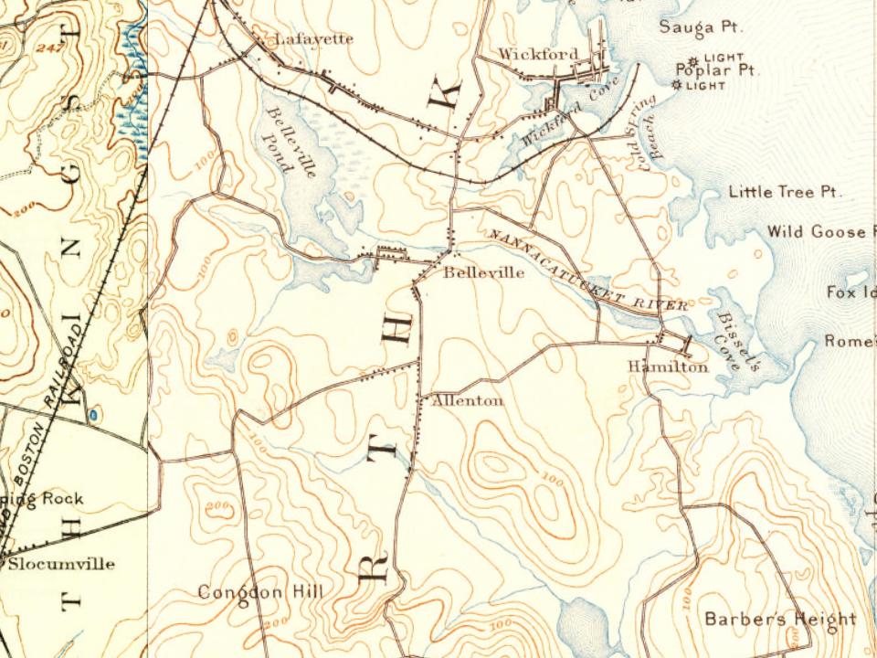
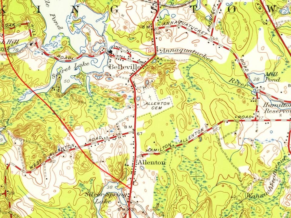
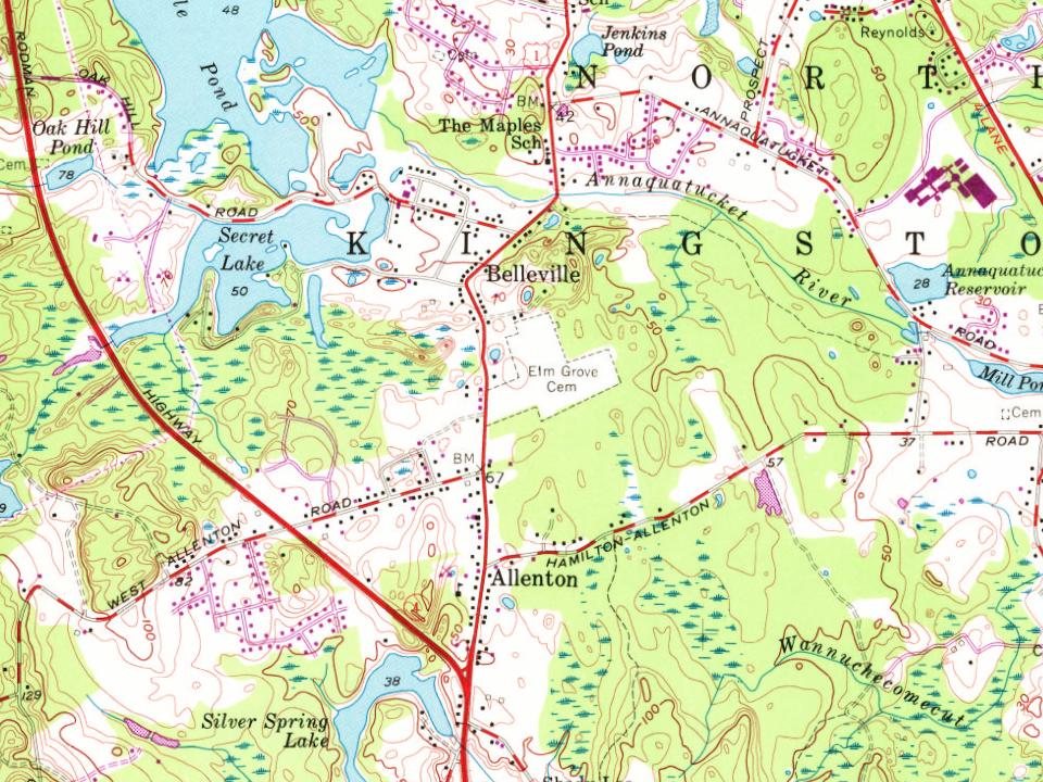
Every edition of the U.S. Geological Survey’s map of North Kingstown. Tap a year, or press play to watch the town change.
1890Narragansett Bay sheet · 1:62,500
U.S. Geological Survey historical topographic maps (public domain), via Esri’s collection of the scans. The red ring marks the center of North Kingstown.
Then & now
Stand where they stood
No then-and-now pairs yet. Take a photo from the same spot as an old one and they appear here side by side.
Retake this viewSlocums station 1909 postcard, 1909
Find the spot, match the angle, and add your photo. It becomes the first then-and-now pair on North Kingstown’s page.
North Kingstown is more historic than 78% of U.S. towns, #29 of 38 in Rhode Island. The History grade combines the town’s founding era, the share of homes built before 1940 and its National Register listings. It’s a character grade, so it isn’t part of the overall grade. How it works.
What is on the National Register in North Kingstown?
29 listings: 15 buildings, among them the Gilbert Stuart Birthplace (a National Historic Landmark since 1965), 11 historic districts with 321 contributing buildings, 1 site, and 2 structures. 345 historic buildings in all.
How old are the homes in North Kingstown?
14% of North Kingstown’s homes were built before 1940 (Census estimate, ±2.3 points), against a typical 20% for a Rhode Island town; the median home was built in 1973.
Founding dates: Wikidata, Wikipedia, the U.S. post office records of Blevins & Helbock (CC0) and the Census. Homes by year built: Census ACS 2020–24. National Register of Historic Places: National Park Service (list of May 22, 2026). Old photos, postcards and papers: Wikimedia Commons, the Library of Congress and other public archives, credited on each item’s page. Maps: U.S. Geological Survey historical topographic maps (via Esri) and Sanborn fire-insurance maps (Library of Congress). History text and census tables: Wikipedia (CC BY-SA 4.0). Places that used to be: USGS Geographic Names Information System (2021).
From Wikimedia Commons (5), the Library of Congress (2), Wikidata (5), the National Register of Historic Places (29), Wikipedia, Wikidata and Wikipedia for famous people, U.S. Geological Survey historical maps, U.S. Census counts (via Wikipedia), the US Post Offices dataset (Blevins & Helbock) and the USGS Geographic Names Information System. Archive images are copied here with their credits and licenses, shown on each photo’s page. Refreshed monthly.


 ★ Landmark




 1914
 1981
 2009
 2008
 2008