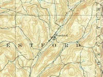
The town was first settled around 1790 by pioneers from Vermont. However, it is claimed that the first settler in Westford was Robert Roseboom from New Jersey, who settled in what is now known as Maple Valley. During the 1790s, Westford received an influx of land-hungry settlers from New England, who established the first churches and schools in Westford.
The town was established from part of the town of Worcester in 1808.
Passages that mention Westford, cut from the printed page as they were published.
Grand Army of the Republic. History of the order in the U. S. by counties. Otsego County posts, Department of New York, including a complete record of soldiers surviving and buried in the county, with company and regiment ... Compiled by D. A. Ellis1892Read the page →
Read the text
M. D. Bentley was bom Dec. 19, 1834, in the town of Westford, Otsego Co., and educated at the common schools and went on a farm. He enlisted in Co. D, 3d N. Y. C. under Capt. Brown, but was rejected by reason of poor sight. Enlisted the second time, was accepted and mustered in at Norwich, N. Y., Aug. 29, 1864 as a private in Co. E, 1 st N. Y. Eng. Joined his company at Point of Rocks, Va., crossed the James and participated in the
Text read by machine from the scan; it may contain errors.
Scans and text from the Internet Archive. Books published in 1930 or earlier, which are in the public domain.
Timeline
Westford, 1790 to 1923
Woven from the archive, old maps, post office records, the National Register and the people born here.
Nothing in the archives for these yearsWeddings on Main Street, storms, parades, school pictures, the old store. If it’s in your family album, it belongs here.
Founding dates: Wikidata, Wikipedia, the U.S. post office records of Blevins & Helbock (CC0) and the Census. Homes by year built: Census ACS 2020–24. National Register of Historic Places: National Park Service (list of May 22, 2026). Old photos, postcards and papers: Wikimedia Commons, the Library of Congress and other public archives, credited on each item’s page. Maps: U.S. Geological Survey historical topographic maps (via Esri) and Sanborn fire-insurance maps (Library of Congress). History text and census tables: Wikipedia (CC BY-SA 4.0). Places that used to be: USGS Geographic Names Information System (2021). How TownRatings grades history →
From Wikimedia Commons (1), Wikipedia, Wikidata and Wikipedia for famous people, U.S. Geological Survey historical maps, U.S. Census counts (via Wikipedia), the US Post Offices dataset (Blevins & Helbock), the USGS Geographic Names Information System and old county and town histories (Internet Archive). Archive images are copied here with their credits and licenses, shown on each photo’s page. Refreshed monthly.