Utica dates to 1734, and 50% of its homes were built before 1940
Among the most historic 1% of U.S. towns · #32 of 758 in New York. What drives it
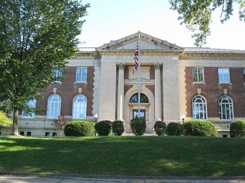
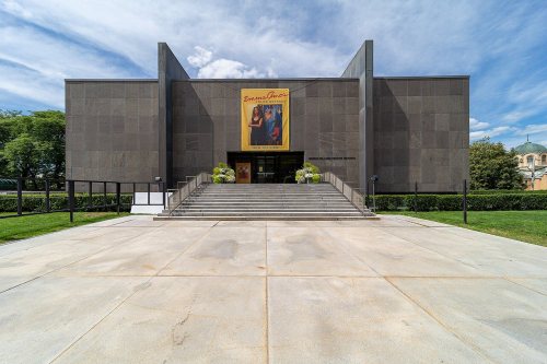
37 places in town are on the National Register, among them 2 National Historic Landmarks and six historic districts with 154 buildings between them. Below: 17 old photos and papers, maps from 1884 on, and the census since 1820.
Founding year: Wikidata. First post office: 1795.The full story ↓
History grade
What drives Utica’s History grade
On its age, its old homes and the National Register, Utica is among the most historic 1% of U.S. towns, #32 of 758 in New York. All 3 inputs are above most U.S. towns; its share of homes from before 1940 ranks highest and its National Register listings lowest.
A+
HistoryA character grade: shown, never part of Utica’s overall grade.
New York towns list more on the Register than most of the country (a typical New York town has 12.3 per 10,000 residents, the U.S. 2.4), so Utica’s 29.4 sits near the middle of its state (61% of New York towns have fewer) while its 189 historic buildings outnumber those of 93% of U.S. towns.
How sure. Graded on any two of the three inputs instead, the letter would still be A+. The pre-1940 share (±2.4 points) is firm at this size. Two sources give 1734.
Founding year: Wikidata (other dates in Quick answers). Homes: Census ACS 2020–24. National Register: National Park Service, May 2026 list; each listing counted once (boundary changes and added documentation belong to their listing), and a historic district counts its contributing buildings. How TownRatings grades history →
What stands out about Utica’s past
Read from the archive, the National Register and the record. The page puts what stands out first.
National Park Service, National Register of Historic Places. Photos from Wikimedia Commons, credited on each place’s page.
Places that used to be
Lost post offices, old corners, places now gone and burying grounds
Utica’s post office has been open since 1799. Three other post offices opened and closed inside today’s town.
Old Fort Schuyler
1795–1799
Utica
1799–today
Deerfield
1833–1834
Deerfield
1853–1922
17901910today
Hamlets and corners on the map
DeerfieldHeritage Acres
Gone or out of use
Alhambra TheaterbuildingAvon TheaterbuildingBleeker Street Public SchoolschoolBrandegee Public SchoolschoolFamily TheaterbuildingHoratio Seymour SchoolschoolJames TheaterbuildingKemble Street SchoolschoolLincoln Public SchoolschoolLincoln TheaterbuildingMary Street SchoolschoolMemorial HospitalhospitalNew Century ClubbuildingOlympic TheaterbuildingOrpheum TheaterbuildingOur Lady of Lourdes ConventchurchRhoads General HospitalhospitalRialto Theaterbuilding
Utica was established on the site of Old Fort Schuyler, built by American colonists for defense in 1758 during the French and Indian War, the North American front of the Seven Years' War against France. Prior to construction of the fort, the Mohawk, Onondaga and Oneida nations of the Iroquois (Haudenosaunee) Confederacy had controlled this area southeast of the Great Lakes region as early as 4000 BC. The Mohawk were the largest and most powerful nation in the eastern and lower Mohawk Valley. Colonists had a long-standing fur trade with the Mohawk, in exchange for firearms and rum. The Iroquois nations' dominating presence in the region prevented the Province of New York from expanding past the middle of the Mohawk Valley until after the American victory over the British and British-allied Iroquois in the Revolutionary War. Following the war several Iroquois nations were forced to cede l…
Passages that mention Utica, cut from the printed page as they were published.
History of Oneida County, New York, 1667-18781878 · page 393Read the page →
Read the text
near the corner of Dominick and Washington Streets, and on the north side of the former, for a harness-shop, by a Mr. Sweatman, the above paper was published in 1818 by E. Dorchester, who removed here from Utica, where be was publishing the Utica Observer, to aid the citizens of Rome and Whitestown, through the influence of his paper, in preventing the courts from being held in the then village of Utica. In 1819 lie returned with bis paper to Utica, gave
Text read by machine from the scan; it may contain errors.
History of Oneida County, New York1878 · page 289Read the page →
Read the text
By the same act of incorporation the district of country included within the limits of the village of Utica was set off from Whitestown, and created a separate town by the name of Utica.
Text read by machine from the scan; it may contain errors.
History of Oneida County, New York, 1667-18781878 · page 289Read the page →
Read the text
By the same act of incorporation the district of country included within the limits of the village of Utica was set off from Whitestown, and created a separate town by the name of Utica.
Text read by machine from the scan; it may contain errors.
History of Oneida County, New York1912 · page 508Read the page →
Read the text
service. lie was offered the position of paymaster in the regular navy at the close of the war but declined, preferring private life. After returning home he engaged in the hotel business as proprietor of the TappanZee House at Xyack, New York. On December 1, 1869, he came to Utica which he has since made his home and purchased Bagg's Hotel of which he was proprietor for twentyone years, also being proprietor of the Butterfield House in Utica for ten years, and later of the Spring House at Richfield Springs, all of which under his management were successful. He also engaged in other lines of activity and is now
Text read by machine from the scan; it may contain errors.
Scans and text from the Internet Archive. Books published in 1930 or earlier, which are in the public domain.
Timeline
Utica, 1734 to 1930
Woven from the archive, old maps, post office records, the National Register and the people born here.
Nothing in the archives for these yearsWeddings on Main Street, storms, parades, school pictures, the old store. If it’s in your family album, it belongs here.
Every edition of the U.S. Geological Survey’s map of Utica. Tap a year, or press play to watch the town change.
1898Utica sheet · 1:62,500
U.S. Geological Survey historical topographic maps (public domain), via Esri’s collection of the scans. The red ring marks the center of Utica.
Every building
Utica, building by building, 1884–1925
Fire insurance maps drew every building, what it was made of and what it was used for, so insurers could price the risk of fire. Pick a year, then a sheet.
In 1734, according to Wikidata. Utica’s post office opened in 1795, and the census of 1820 counted 2,972 people here.
How does Utica rank for history?
Utica is among the most historic 1% of U.S. towns, #32 of 758 in New York. The History grade combines the town’s founding era, the share of homes built before 1940 and its National Register listings. It’s a character grade, so it isn’t part of the overall grade. How it works.
What is on the National Register in Utica?
37 listings, 2 of them National Historic Landmarks: 31 buildings, among them the Utica State Hospital (a National Historic Landmark since 1989), and 6 historic districts with 154 contributing buildings. 189 historic buildings in all.
How old are the homes in Utica?
50% of Utica’s homes were built before 1940 (Census estimate, ±2.4 points), against a typical 27% for a New York town; the median home was built in 1940.
Founding dates: Wikidata, Wikipedia, the U.S. post office records of Blevins & Helbock (CC0) and the Census. Homes by year built: Census ACS 2020–24. National Register of Historic Places: National Park Service (list of May 22, 2026). Old photos, postcards and papers: Wikimedia Commons, the Library of Congress and other public archives, credited on each item’s page. Maps: U.S. Geological Survey historical topographic maps (via Esri) and Sanborn fire-insurance maps (Library of Congress). History text and census tables: Wikipedia (CC BY-SA 4.0). Places that used to be: USGS Geographic Names Information System (2021).
From Wikimedia Commons (17), Wikidata (1), the National Register of Historic Places (37), Wikipedia, U.S. Geological Survey historical maps, U.S. Census counts (via Wikipedia), the US Post Offices dataset (Blevins & Helbock), the USGS Geographic Names Information System, Sanborn fire insurance maps (Library of Congress) and old county and town histories (Internet Archive). Archive images are copied here with their credits and licenses, shown on each photo’s page. Refreshed monthly.


 ★ Landmark
 ★ Landmark




 c. 1845
 1848
 1878
 1879
 1888
 1892
 1898
 1898
 1900
 1900
 1900


