Rye dates to 1660, and 30% of its homes were built before 1940
More historic than 96% of U.S. towns · #127 of 758 in New York. What drives it
9 places in town are on the National Register, among them 2 National Historic Landmarks and three historic districts with 39 buildings between them. Below: 10 old photos and papers, maps from 1887 on, and the census since 1910.
Founding year: Wikidata; Wikipedia’s history section gives the same year. First post office: 1803.The full story ↓
History grade
What drives Rye’s History grade
On its age, its old homes and the National Register, Rye is more historic than 96% of U.S. towns, #127 of 758 in New York. All 3 inputs are above most U.S. towns; its age ranks highest and its National Register listings lowest.
A+
HistoryA character grade: shown, never part of Rye’s overall grade.
New York towns list more on the Register than most of the country (a typical New York town has 12.3 per 10,000 residents, the U.S. 2.4), so Rye’s 29.2 sits near the middle of its state (61% of New York towns have fewer) while its 48 historic buildings outnumber those of 85% of U.S. towns.
How sure. Graded on any two of the three inputs instead, the letter would range from A to A+. The pre-1940 share is a Census survey estimate (±3.6 points). Two sources give 1660.
Founding year: Wikidata (other dates in Quick answers). Homes: Census ACS 2020–24. National Register: National Park Service, May 2026 list; each listing counted once (boundary changes and added documentation belong to their listing), and a historic district counts its contributing buildings. How TownRatings grades history →
What stands out about Rye’s past
Read from the archive, the National Register and the record. The page puts what stands out first.
Rye was once a part of Fairfield County, Connecticut, belonging to the Sachem Ponus, of the Ponus Wekuwuhm, Canaan Parish, and was probably named for that chieftain, "Peningoe Neck".
It was founded in 1660 by three men: Thomas Studwell, Peter Disbrow, and John Coe. Later prominent landowners included John Budd and family. Rye officially became part of the Province of New York and Westchester County in 1683 when Connecticut Colony ceded the town as part of a boundary agreement, though a final legal dispute over the boundary was not fully resolved until 1700. (Rye attempted to secede from New York and rejoin the Connecticut Colony in 1697. This brief rebellion, known as the "Revolt of Rye," lasted until 1700.)
Passages that mention Rye, cut from the printed page as they were published.
History of Westchester county, New York, including Morrisania, Kings Bridge, and West Farms, which have been annexed to New York city1886 · page 719Read the page →
Read the text
** Shall not gire the said Colonel Heathcote any ftirther tiUe than that which he already hath to the land called White Plains, which is in dispute between the said Caleb Heathcote and the inhabitants of the town of Rye. The sheriff returned that the 'Jurors found there is no damage to the King or his suljects in erecting the manor aforesaid, except the MThite Plains, which are in diqNita and contest between said Caleb Heathcote and the town of Rye, and excepting James Mott and the rest of the purchasers of Mamaroneck, which hare land within the patent of Rich-
Text read by machine from the scan; it may contain errors.
History of Westchester county, New York, including Morrisania, Kings Bridge, and West Farms, which have been annexed to New York city1886 · page 872Read the page →
Read the text
cincts of the Parish of Rye, one of the two territorial parishes erected in Westchester County in the former year under the Act establishing parishes of the Church of England within the Counties of New York and Westchester passed March 24, 1698,* an act which with several amendments made in later years continued in force till repealed by the Legislature of the State in the year 1784, just about a hundred years. The Estab-
Text read by machine from the scan; it may contain errors.
Scans and text from the Internet Archive. Books published in 1930 or earlier, which are in the public domain.
By decade
Rye, decade by decade
3 decades in the archive, from the 1870s to the 1910s. Scroll each row; tap a photo for its story.
Nothing in the archives for these yearsWeddings on Main Street, storms, parades, school pictures, the old store. If it’s in your family album, it belongs here.
Fire insurance maps drew every building, what it was made of and what it was used for, so insurers could price the risk of fire. Pick a year, then a sheet.
1887Sheet 1 of 1
Edition
Sheets
BrickWoodStone
Sanborn Map Company, via the Library of Congress. Editions published in 1930 or earlier, which are in the public domain.
Then & now
Stand where they stood
No then-and-now pairs yet. Take a photo from the same spot as an old one and they appear here side by side.
Retake this viewPlate 60- Mamaroneck, Westchester Co. N.Y. - Ryeneck, Town of Rye, Westchester Co. N.Y, 1872
Find the spot, match the angle, and add your photo. It becomes the first then-and-now pair on Rye’s page.
In 1660, according to Wikidata and Wikipedia’s history of the town. Rye’s post office opened in 1803, and the census of 1910 counted 3,964 people here.
How does Rye rank for history?
Rye is more historic than 96% of U.S. towns, #127 of 758 in New York. The History grade combines the town’s founding era, the share of homes built before 1940 and its National Register listings. It’s a character grade, so it isn’t part of the overall grade. How it works.
What is on the National Register in Rye?
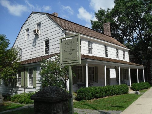
9 listings, 2 of them National Historic Landmarks: 4 buildings, among them the Widow Haviland's Tavern (listed 1974, the first), 3 historic districts, the Playland Amusement Park, the Boston Post Road Historic District and the Timothy Knapp House and Milton Cemetery, with 39 contributing buildings, and 2 sites. 48 historic buildings in all.
How old are the homes in Rye?
30% of Rye’s homes were built before 1940 (Census estimate, ±3.6 points), against a typical 27% for a New York town; the median home was built in 1957.
Founding dates: Wikidata, Wikipedia, the U.S. post office records of Blevins & Helbock (CC0) and the Census. Homes by year built: Census ACS 2020–24. National Register of Historic Places: National Park Service (list of May 22, 2026). Old photos, postcards and papers: Wikimedia Commons, the Library of Congress and other public archives, credited on each item’s page. Maps: U.S. Geological Survey historical topographic maps (via Esri) and Sanborn fire-insurance maps (Library of Congress). History text and census tables: Wikipedia (CC BY-SA 4.0). Places that used to be: USGS Geographic Names Information System (2021).
From Wikimedia Commons (10), Wikidata (2), the National Register of Historic Places (9), Wikipedia, Wikidata and Wikipedia for famous people, U.S. Geological Survey historical maps, U.S. Census counts (via Wikipedia), the US Post Offices dataset (Blevins & Helbock), the USGS Geographic Names Information System, Sanborn fire insurance maps (Library of Congress) and old county and town histories (Internet Archive). Archive images are copied here with their credits and licenses, shown on each photo’s page. Refreshed monthly.


 ★ Landmark


 1872
 c. 1874
 1911
 1911
 c. 1912
 1912
 1912

