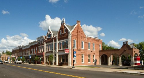
Richland dates to 1801, and 27% of its homes were built before 1940
More historic than 91% of U.S. towns · #256 of 758 in New York. What drives it
2 places in town are on the National Register, among them a historic district with 37 buildings. Below: 4 old photos and papers, maps from 1895 on, and the census since 1820.
Founding year: Wikipedia. First post office: 1817.The full story ↓
History grade
What drives Richland’s History grade
On its age, its old homes and the National Register, Richland is more historic than 91% of U.S. towns, #256 of 758 in New York. All 3 inputs are above most U.S. towns; its share of homes from before 1940 ranks highest and its age lowest.
A
HistoryA character grade: shown, never part of Richland’s overall grade.
New York towns list more on the Register than most of the country (a typical New York town has 12.3 per 10,000 residents, the U.S. 2.4), so Richland’s 64.7 sits above most of its state (71% of New York towns have fewer) while its 37 historic buildings outnumber those of 83% of U.S. towns.
How sure. Graded on any two of the three inputs instead, the letter would range from A− to A. The pre-1940 share is a Census survey estimate (±5.1 points). Two sources give 1801.
Founding year: Wikipedia (other dates in Quick answers). Homes: Census ACS 2020–24. National Register: National Park Service, May 2026 list; each listing counted once (boundary changes and added documentation belong to their listing), and a historic district counts its contributing buildings. How TownRatings grades history →
What stands out about Richland’s past
Read from the archive, the National Register and the record. The page puts what stands out first.
Lost post offices, old corners, places now gone and burying grounds
Richland had its own post office from 1817 to 1853. Five other post offices opened and closed inside today’s town.
Richland
1817–1853
Port Ontario
1837–1902
South Richland
1844–1899
Pulaski
1853–today
Richland Station
1861–1868
Daysville
1868–1907
Richland
1868–today
Fernwood
1899–1969
18101920today
Hamlets and corners on the map
Bethel CornersBrennan Beach Mobile Home ParkDaysvilleDaysville CornerFarmers CornerFernwoodLapointe Manor Mobile Home ParkPort OntarioPulaskiRainbow ShoresRamona BeachSelkirkTinker Tavern CornerTylers Corner
Gone or out of use
Bethel ChurchchurchPulaski AirportairportSchool Number 13schoolSchool Number 13schoolSchool Number 19schoolSchool Number 9school
8cemeteries and burying grounds inside Richland
Blue SpringsBrown's LandingDaysvilleMcClellandPulaski VillageRichland VillageRiversideSouth Richland
US Post Offices dataset (Blevins & Helbock, CC0). Places and cemeteries from the USGS Geographic Names Information System (2021).
Help out
Start Richland’s collection
The first neighbors to add old photos shape how Richland’s history is told.
Decades since 1900 with photos
00s10s20s30s40s50s60s70s80s90s
0 of 10 decades. The empty ones are waiting for someone’s album.
Passages that mention Richland, cut from the printed page as they were published.
... History of Oswego County, New York1877 · page 116Read the page →
Read the text
The articles of the Oswego and Rome railroad company had been filed in April, 1863. It was built from Richland station, in the town of Richland, through the village of Pulaski and the towns of Mexico, New Haven, and Soriba, to Oswego city, being completed to the latter place in the autumn of 1865. Immediately after the organization of the company, even before the building of the road, it was leased in perpetuity to the Rome, Watertown and Ogdens-
Text read by machine from the scan; it may contain errors.
The territory cuibraceJ within the present boundaries of this town originally comprised a portion of the old town of Williamstown, then Oneida county, which was formed March 24, 1804. Richland was set off February 20, 1807, and Albion erected from Richland, March 24, 1825. The surface is gently undulating, and the highest point in town is three hundred and ninety-two feet above Lake Ontario. It is watered by the Salmon river, which enters
Text read by machine from the scan; it may contain errors.
History of Richland County, Ohio, from 1808 to 1908. Also biographical sketches of prominent citizens of the county1908 · page 924Read the page →
Read the text
The name of Cline is an old and prominent one in Richland county, for representativcis of the family came here at a very early period in its history and have been identified with its agricultural interests from that time to the present. The family was established here by Michael Cline, who came from Beaver county, Pennsylvania, and spent his remaining days in Richland county. His son Jacob Cline entered eighty acres of land from the government, going to Wooster to secure his deed and not having sufficient funds to make full payment left his saddle and bridle to be redeemed upon payment
Text read by machine from the scan; it may contain errors.
History of Richland County, Ohio, from 1808 to 1908. Also biographical sketches of prominent citizens of the county1908 · page 978Read the page →
Read the text
Mr. Gribling is today the only representative of either his father's or mother's families in Richland county. His present home has been in possession of the family for almost a half century and no man in Richland county is more Digitized by Google
Text read by machine from the scan; it may contain errors.
Scans and text from the Internet Archive. Books published in 1930 or earlier, which are in the public domain.
Timeline
Richland, 1801 to 1902
Woven from the archive, old maps, post office records, the National Register and the people born here.
In 1801, according to Wikipedia’s history of the town. Richland’s post office opened in 1817, and the census of 1820 counted 488 people here.
How does Richland rank for history?
Richland is more historic than 91% of U.S. towns, #256 of 758 in New York. The History grade combines the town’s founding era, the share of homes built before 1940 and its National Register listings. It’s a character grade, so it isn’t part of the overall grade. How it works.
What is on the National Register in Richland?
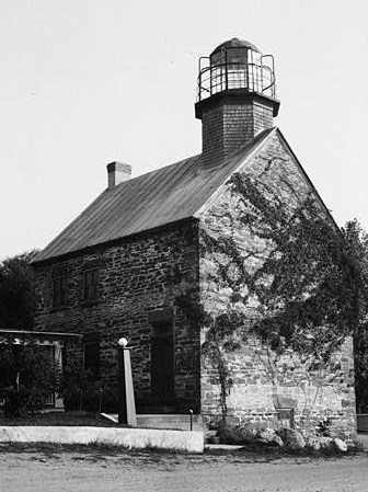
Two places: the Selkirk Lighthouse (listed 1979) and the Pulaski Village Historic District (1983).
How old are the homes in Richland?
27% of Richland’s homes were built before 1940 (Census estimate, ±5.1 points), against a typical 27% for a New York town; the median home was built in 1970.
Founding dates: Wikidata, Wikipedia, the U.S. post office records of Blevins & Helbock (CC0) and the Census. Homes by year built: Census ACS 2020–24. National Register of Historic Places: National Park Service (list of May 22, 2026). Old photos, postcards and papers: Wikimedia Commons, the Library of Congress and other public archives, credited on each item’s page. Maps: U.S. Geological Survey historical topographic maps (via Esri) and Sanborn fire-insurance maps (Library of Congress). History text and census tables: Wikipedia (CC BY-SA 4.0). Places that used to be: USGS Geographic Names Information System (2021).
From Wikimedia Commons (3), the Library of Congress (1), the National Register of Historic Places (2), Wikipedia, U.S. Geological Survey historical maps, U.S. Census counts (via Wikipedia), the US Post Offices dataset (Blevins & Helbock), the USGS Geographic Names Information System and old county and town histories (Internet Archive). Archive images are copied here with their credits and licenses, shown on each photo’s page. Refreshed monthly.




 1861
 1864
 1867