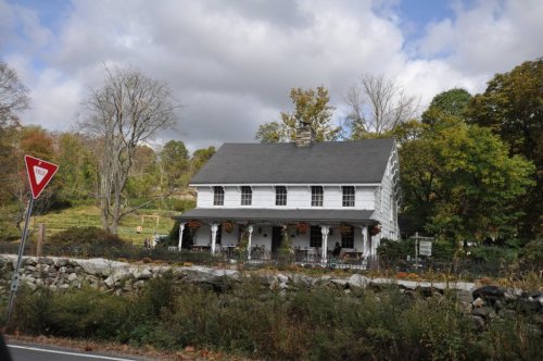
North Salem’s post office opened in 1819, and 35% of its homes were built before 1940
More historic than 86% of U.S. towns · #333 of 758 in New York. What drives it
Its Register listings are the Joseph Purdy Homestead, the North Salem Town Hall and the Union Hall. Below: 4 old photos and papers, maps from 1892 on, and the census since 1790.
From North Salem’s archive · credits on each photo
Quick answers
How North Salem began
When was North Salem founded?
1819
The North Salem post office opened in 1819, the earliest record of the town by name. Three smaller post offices, Salem Center (1826), Owenville (1833) and Purdy Station (1849), opened inside today’s town and later closed.
First census: 1,058 in 17902020 census: 5,243207 years
How historic is North Salem?
A
More historic than 86% of U.S. towns, on its age, its old homes and the National Register.
Founding year: the first North Salem post office (Blevins & Helbock, CC0).The full story ↓
History grade
What drives North Salem’s History grade
On its age, its old homes and the National Register, North Salem is more historic than 86% of U.S. towns, #333 of 758 in New York. All 3 inputs are above most U.S. towns; its share of homes from before 1940 ranks highest and its National Register listings lowest.
A
HistoryA character grade: shown, never part of North Salem’s overall grade.
New York towns list more on the Register than most of the country (a typical New York town has 12.3 per 10,000 residents, the U.S. 2.4), so North Salem’s 7.8 sits near the middle of its state (42% of New York towns have fewer) while its 4 historic buildings outnumber those of 68% of U.S. towns.
How sure. Graded on any two of the three inputs instead, the letter would range from B+ to A. The pre-1940 share is a Census survey estimate (±7.8 points). The founding year is the first post office, not a stated founding date.
Founding year: the first post office (other dates in Quick answers). Homes: Census ACS 2020–24. National Register: National Park Service, May 2026 list; each listing counted once (boundary changes and added documentation belong to their listing), and a historic district counts its contributing buildings. How TownRatings grades history →
What stands out about North Salem’s past
Read from the archive, the National Register and the record. The page puts what stands out first.
The land which currently comprises North Salem has been inhabited for about 12,000 years. Prior to the American Revolution, the territory was home to the Algonquian peoples, who lived in the village of Pequenakonck, where the hamlet of Peach Lake is today. Dutch explorers entered the area in the 1600s; towards the end of the seventeenth century, the land became the property of Stephanus Van Cortlandt, a wealthy New York politician, alongside a significant portion of what is today northern Westchester County.
Permanent European settlement began in the early 1700s. By the late Colonial Era, a single municipality, Salem, had been established in the area, its borders including both future North and South Salem.
Passages that mention North Salem, cut from the printed page as they were published.
History of Westchester County, New York, from its earliest settlement to the year 19001900 · page 614Read the page →
Read the text
says : "The additional land required for the construction of theNewCroton Reseiwoir has been taken from the Towns of Cortlandt, Yorktown, New Castle, Bedford, Somers, Lewisboro, aud North Salem, in Westchester County, covering an area of 0,398.244 acres. From the Town of Cortlandt, 752.654 acres were taken; from the Town of Yorktown, 1,752.932 acres were taken; from the Town of New Castle, 151.697 acres; from the Town of Bedford, 801.860 acres; from the Town of
Text read by machine from the scan; it may contain errors.
History of Westchester County, New York, from its earliest settlement to the year 19001900 · page 607Read the page →
Read the text
a citizen of Westchester County. He was one of the early incomers from New York City after the opening of the railways. In the summer of 1850 he lived with his family on the Todd Bailey estate in the Town of North Salem.1 We have seen that during the same year he took a very prominent part in the steps which led to the settlement of Mount Vernon. In 1851 he purchased a farm of seventy-five acres at Chappaqua in the Town of New Castle. Unlike most other prominent New Yorkers who came to Westchester County to live,
Text read by machine from the scan; it may contain errors.
Scans and text from the Internet Archive. Books published in 1930 or earlier, which are in the public domain.
Timeline
North Salem, 1819 to 2020
Woven from the archive, old maps, post office records, the National Register and the people born here.
Nothing in the archives for these yearsWeddings on Main Street, storms, parades, school pictures, the old store. If it’s in your family album, it belongs here.
The North Salem post office opened in 1819, the earliest record of the town by name (U.S. post office records).
How does North Salem rank for history?
North Salem is more historic than 86% of U.S. towns, #333 of 758 in New York. The History grade combines the town’s founding era, the share of homes built before 1940 and its National Register listings. It’s a character grade, so it isn’t part of the overall grade. How it works.
What is on the National Register in North Salem?
Three places: the Joseph Purdy Homestead (listed 1973), the North Salem Town Hall (1980) and the Union Hall (1986).
How old are the homes in North Salem?
35% of North Salem’s homes were built before 1940 (Census estimate, ±7.8 points), against a typical 27% for a New York town; the median home was built in 1963.
Founding dates: Wikidata, Wikipedia, the U.S. post office records of Blevins & Helbock (CC0) and the Census. Homes by year built: Census ACS 2020–24. National Register of Historic Places: National Park Service (list of May 22, 2026). Old photos, postcards and papers: Wikimedia Commons, the Library of Congress and other public archives, credited on each item’s page. Maps: U.S. Geological Survey historical topographic maps (via Esri) and Sanborn fire-insurance maps (Library of Congress). History text and census tables: Wikipedia (CC BY-SA 4.0). Places that used to be: USGS Geographic Names Information System (2021).
From Wikimedia Commons (6), the National Register of Historic Places (3), Wikipedia, Wikidata and Wikipedia for famous people, U.S. Geological Survey historical maps, U.S. Census counts (via Wikipedia), the US Post Offices dataset (Blevins & Helbock), the USGS Geographic Names Information System and old county and town histories (Internet Archive). Archive images are copied here with their credits and licenses, shown on each photo’s page. Refreshed monthly.


 1933
 1933
 2006
 2006