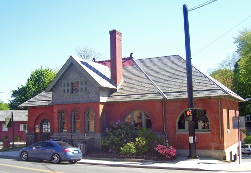
On its age, its old homes and the National Register, Southeast is more historic than 59% of U.S. towns, #609 of 758 in New York. Its share of homes from before 1940 holds the grade up; its National Register listings pull it down.
B
HistoryA character grade: shown, never part of Southeast’s overall grade.
New York towns list more on the Register than most of the country (a typical New York town has 12.3 per 10,000 residents, the U.S. 2.4), so Southeast’s 2.8 sits below most of its state (28% of New York towns have fewer) while its 5 listings outnumber those of 70% of U.S. towns.
How sure. Graded on two of the three inputs, so a change in either one moves the letter more than it would with three. The pre-1940 share (±2.8 points) is firm at this size.
Founding year: our sources. Homes: Census ACS 2020–24. National Register: National Park Service, May 2026 list; each listing counted once (boundary changes and added documentation belong to their listing), and a historic district counts its contributing buildings. How TownRatings grades history →
What stands out about Southeast’s past
Read from the archive, the National Register and the record. The page puts what stands out first.
The first settler arrived circa 1730. The area first exploited was called "The Oblong," and was outside of the land claimed by the Philipse Patent. Due to a border dispute between New York and Connecticut, the area between the undisputed border of New York and the undisputed border of Connecticut was an approximately 4-mile-wide (6 km) area which ran the full north-south dimension along the state line, in what are now Westchester, Putnam, Dutchess, and Columbia Counties. This was called the Oblong. Land was sold in this area, both by the governor of New York and the King of England for Connecticut, with conflicting deeds. The boundary was settled in New York's favor by the 1731 Treaty of Dover.
THE town of Patterson includes the north half of Lot No. 8 of Philipse Patent, the greater pare of Lot No. 7, and that portion of the Oblong which is in this county, and lies north of the north line of the town of Southeast. This town, which was originally a part of the Fredericksburg Precinct, and afterward of Frederickstown, was reduced to its present dimensions and established as the town of Franklin by an Act of the Legislature passed March 17th, 1795. The first town meeting was held
Text read by machine from the scan; it may contain errors.
History of Putnam County, New York1886 · page 141Read the page →
Read the text
Benjamin Cowls and Abijah Seeley and their associates were authorized " to make a good and sufficient road from the north end of the Croton Turnpike near the house of widow Deborah Sears, in the town of Southeast, and running thence the most direct route to the house of Abijah Seeley, in the town of Patterson and thence by the most direct route to the bridge across Croton River about one half mile west of Capt. Benjamin Cowls, thence eastwardly to the Connecticut line, terminating at the
Text read by machine from the scan; it may contain errors.
The history of Putnam County, N.Y.1849 · page 281Read the page →
Read the text
of Carmel Village, and a log building erected on the hill a few rods north of the present residence of Ira White, Esq., and within the limits of the town of Southeast. The Society was familiarly known as " Gregory's Parish," after the name of their first minister. No authentic records of the Church are found until 1792, when a new organization was made, and a more commodious edifice built upon the ground now
Text read by machine from the scan; it may contain errors.
of Carmel Village, and a log building erected on the hill a few rods north of the present residence of Ira White, Esq., and within the limits of the town of Southeast. The Society was familiarly known as '•'Gregory's Parish/' alter the name of their first minister. No authentic records of the Church are found until 1792, when a new organization was made, and a more commodious edifice built upon the ground now
Text read by machine from the scan; it may contain errors.
Scans and text from the Internet Archive. Books published in 1930 or earlier, which are in the public domain.
Timeline
Southeast, 1794 to 2010
Woven from the archive, old maps, post office records, the National Register and the people born here.
Southeast is more historic than 59% of U.S. towns, #609 of 758 in New York. The History grade combines the town’s founding era, the share of homes built before 1940 and its National Register listings. It’s a character grade, so it isn’t part of the overall grade. How it works.
What is on the National Register in Southeast?
5 listings: 5 buildings, among them the Old Southeast Church (listed 1972, the first).
How old are the homes in Southeast?
16% of Southeast’s homes were built before 1940 (Census estimate, ±2.8 points), against a typical 27% for a New York town; the median home was built in 1975.
Founding dates: Wikidata, Wikipedia, the U.S. post office records of Blevins & Helbock (CC0) and the Census. Homes by year built: Census ACS 2020–24. National Register of Historic Places: National Park Service (list of May 22, 2026). Old photos, postcards and papers: Wikimedia Commons, the Library of Congress and other public archives, credited on each item’s page. Maps: U.S. Geological Survey historical topographic maps (via Esri) and Sanborn fire-insurance maps (Library of Congress). History text and census tables: Wikipedia (CC BY-SA 4.0). Places that used to be: USGS Geographic Names Information System (2021).
From Wikimedia Commons (17), Wikidata (1), the National Register of Historic Places (5), Wikipedia, U.S. Geological Survey historical maps, U.S. Census counts (via Wikipedia), the US Post Offices dataset (Blevins & Helbock), the USGS Geographic Names Information System and old county and town histories (Internet Archive). Archive images are copied here with their credits and licenses, shown on each photo’s page. Refreshed monthly.


 2021
 2019
 2019
 2019
 2018
 2011
 2009
 2008
 2008
 2007
 2006
 2006
 2006
 2006
 2005
 2004
 2004