Maine’s post office opened in 1828, and 20% of its homes were built before 1940
More historic than 81% of U.S. towns · #406 of 758 in New York. What drives it
2 places in town are on the National Register, among them a historic district with 7 buildings. Below: 8 old photos and papers, maps from 1901 on, and the census since 1850.
The Maine post office opened in 1828, the earliest record of the town by name. Three smaller post offices, East Maine (1849), New Ireland (1894) and Tiona (1897), opened inside today’s town and later closed.
First census: 1,843 in 18502020 census: 5,168198 years
How historic is Maine?
A−
More historic than 81% of U.S. towns, on its age, its old homes and the National Register.
Founding year: the first Maine post office (Blevins & Helbock, CC0).The full story ↓
History grade
What drives Maine’s History grade
On its age, its old homes and the National Register, Maine is more historic than 81% of U.S. towns, #406 of 758 in New York. All 3 inputs are above most U.S. towns; its age ranks highest and its National Register listings lowest.
A−
HistoryA character grade: shown, never part of Maine’s overall grade.
New York towns list more on the Register than most of the country (a typical New York town has 12.3 per 10,000 residents, the U.S. 2.4), so Maine’s 15.7 sits near the middle of its state (52% of New York towns have fewer) while its 8 historic buildings outnumber those of 74% of U.S. towns.
How sure. Graded on any two of the three inputs instead, the letter would range from B+ to A−. The pre-1940 share is a Census survey estimate (±12.4 points). The founding year is the first post office, not a stated founding date.
Founding year: the first post office (other dates in Quick answers). Homes: Census ACS 2020–24. National Register: National Park Service, May 2026 list; each listing counted once (boundary changes and added documentation belong to their listing), and a historic district counts its contributing buildings. How TownRatings grades history →
What stands out about Maine’s past
Read from the archive, the National Register and the record. The page puts what stands out first.
The area was first settled in 1794. The town of Maine was formed from the northern part of the town of Union in 1848.
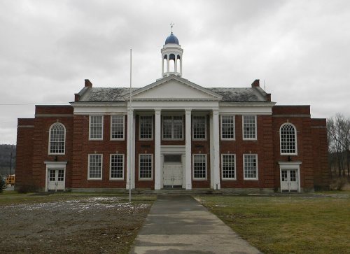
The Maine Central School (also known as J. Ralph Ingals School) was listed on the National Register of Historic Places in 1998. The Cyrus Gates Farmstead was listed in 1999.
Passages that mention Maine, cut from the printed page as they were published.
Illustrated history of Kennebec County, Maine, 1625-1799-18921892 · page 1243Read the page →
Read the text
south by Benton and west by Fairfield. The surface of the town is rolling, crossed by several small streams, and is altogether an ideal farming district. The soil is a clay loam, yielding rich and abundant crops of hay. The trunk line of the Maine Central railroad runs through the southeastern portion of the town, having a station at Clinton village, where most of the present manufacturing industries — including saw mills, a grist mill, carding mill, tannery, door and sash factory and a boot and shoe factory— are located. Pishon's Ferry, on
Text read by machine from the scan; it may contain errors.
Illustrated history of Kennebec County, Maine, 1625-1799-18921892 · page 1034Read the page →
Read the text
SIDXEY, formerly that part of Vassalboro lyingwest of the Kennebec river, was named after Sir Philip Sidney, and incorporated January 30, 1792 — the seventy-.sixth town in the province of Maine. No equal area of Kennebec county was settled, or enjoyed the benefits of township any earlier, or possessed superior attractions for settlement. After inspecting the adjacent sections on either side, an observer must have been agreeably impressed, then as now, with its comparatively level surface and the infrequency of rugged hills
Text read by machine from the scan; it may contain errors.
Genealogical and family history of the state of Maine1909Read the page →
Read the text
body at Princeton, began the study of medicine in September, 1861, with Drs. Job Holmes and Charles E. Swan, of Calais. He attended the medical lectures at the Maine Medical School in 1862, Plarvard in 1863 and Maine in 1864, graduating from the Maine school August 3, 1864. After practicing in Gorham, Maine, from March, 1865, to February, 1869,
Text read by machine from the scan; it may contain errors.
History of Castine, Penobscot, and Brooksville, Maine1875 · page 160Read the page →
Read the text
Sundry Post-offices in the District of Maine, being possessed by, or under the control of, the public enemy, and it being possible that others may be in the same situation, it is hereby ordered, that the Post Master (at the nearest safe Post-office to those offices so possessed or controlled by the enemy) detain, open and account for the mails addressed to them, in the same manner as if addressed to his own office. Whenever it shall become safe to forward
Text read by machine from the scan; it may contain errors.
Scans and text from the Internet Archive. Books published in 1930 or earlier, which are in the public domain.
Timeline
Maine, 1828 to 1970
Woven from the archive, old maps, post office records, the National Register and the people born here.
Nothing in the archives for these yearsWeddings on Main Street, storms, parades, school pictures, the old store. If it’s in your family album, it belongs here.
Nothing in the archives for these yearsWeddings on Main Street, storms, parades, school pictures, the old store. If it’s in your family album, it belongs here.
The Maine post office opened in 1828, the earliest record of the town by name (U.S. post office records).
How does Maine rank for history?
Maine is more historic than 81% of U.S. towns, #406 of 758 in New York. The History grade combines the town’s founding era, the share of homes built before 1940 and its National Register listings. It’s a character grade, so it isn’t part of the overall grade. How it works.
What is on the National Register in Maine?
Two places: the Maine Central School (listed 1998) and the Cyrus Gates Farmstead (1999).
How old are the homes in Maine?
20% of Maine’s homes were built before 1940 (Census estimate, ±12.4 points), against a typical 27% for a New York town; the median home was built in 1964.
Founding dates: Wikidata, Wikipedia, the U.S. post office records of Blevins & Helbock (CC0) and the Census. Homes by year built: Census ACS 2020–24. National Register of Historic Places: National Park Service (list of May 22, 2026). Old photos, postcards and papers: Wikimedia Commons, the Library of Congress and other public archives, credited on each item’s page. Maps: U.S. Geological Survey historical topographic maps (via Esri) and Sanborn fire-insurance maps (Library of Congress). History text and census tables: Wikipedia (CC BY-SA 4.0). Places that used to be: USGS Geographic Names Information System (2021).
From Wikimedia Commons (8), the National Register of Historic Places (2), Wikipedia, Wikidata and Wikipedia for famous people, U.S. Geological Survey historical maps, U.S. Census counts (via Wikipedia), the US Post Offices dataset (Blevins & Helbock), the USGS Geographic Names Information System and old county and town histories (Internet Archive). Archive images are copied here with their credits and licenses, shown on each photo’s page. Refreshed monthly.


 1876
 1876
 1876
 1910