Geneseo’s historic district, a National Historic Landmark, takes in 414 buildings
More historic than 94% of U.S. towns · #163 of 758 in New York. What drives it
4 places in town are on the National Register, among them 2 National Historic Landmarks and two historic districts with 414 buildings between them. Below: 6 old photos and papers, maps from 1885 on, and the census since 1820.
Founding year: Wikidata; Wikipedia’s history section gives the same year. First post office: 1806.The full story ↓
History grade
What drives Geneseo’s History grade
On its age, its old homes and the National Register, Geneseo is more historic than 94% of U.S. towns, #163 of 758 in New York. All 3 inputs are above most U.S. towns; its National Register listings ranks highest and its age lowest.
A
HistoryA character grade: shown, never part of Geneseo’s overall grade.
New York towns list more on the Register than most of the country (a typical New York town has 12.3 per 10,000 residents, the U.S. 2.4), so Geneseo’s 416 sits above most of its state (90% of New York towns have fewer) while its 430 historic buildings outnumber those of 97% of U.S. towns.
How sure. Graded on any two of the three inputs instead, the letter would range from A− to A. The pre-1940 share is a Census survey estimate (±5.1 points). Two sources give 1789.
Founding year: Wikidata (other dates in Quick answers). Homes: Census ACS 2020–24. National Register: National Park Service, May 2026 list; each listing counted once (boundary changes and added documentation belong to their listing), and a historic district counts its contributing buildings. How TownRatings grades history →
What stands out about Geneseo’s past
Read from the archive, the National Register and the record. The page puts what stands out first.
The country’s official list of buildings and places worth saving. 2 are National Historic Landmarks, the highest tier. Boundary changes and added documentation are counted with their listing.
National Park Service, National Register of Historic Places. Photos from Wikimedia Commons, credited on each place’s page.
Every building
Geneseo, building by building, 1885–1913
Fire insurance maps drew every building, what it was made of and what it was used for, so insurers could price the risk of fire. Pick a year, then a sheet.
Near Geneseo was the largest Seneca village, Jo’néhsi:yo:h, a center of power for the Haudenosaunee Confederacy. It was also the confederacy's "bread basket", with orchards, vineyards, and fields of maize and vegetables.
Passages that mention Geneseo, cut from the printed page as they were published.
1687. History of Livingston County, New York, with illustrations and biographical sketches of some of its prominent men and pioneers1881 · page 371Read the page →
Read the text
The church originally extended over the entire town of Geneseo, and the principal place of worship was in a building that stood on what is now known as Temple hill, above the village of Geneseo. The first members of this church were nearly all Presbyterians. Afterwards a number of members of the Congregational order came here from the Eastern States. They were attached to the
Text read by machine from the scan; it may contain errors.
History of Livingston County, New York, from its earliest traditions to the present1905 · page 362Read the page →
Read the text
■Gerrit Smith delivered an address at a meeting held at the Presbyterian Church in Geneseo, on the 1st day of September, 1838. At this meeting, according to the record, "there was a respectable audience from several towns in the county, and among them a fciv from the Village of Geneseo." It is apparent from the emphasis with which the secretary records the word "few," that the attendance from Geneseo was not up to his notion of what it should have been.
Text read by machine from the scan; it may contain errors.
History of Livingston County, New York, from its earliest traditions to the present1905Read the page →
Read the text
It was resolved to hold the treaty at Big Tree, near the settlement which afterwards became Geneseo. In meadow lands within the corporate limits of the village of Geneseo, southwest from the park, about a quarter of a mile above the Erie railroad and about the same distance west of the Mount Morris road, there stood until 1000 a cobblestone house; on the site of this building there was at the time of the treaty a small dwelling erected by William and James Wadsworth in 1701.1 This was rented by Thomas Morris for the
Text read by machine from the scan; it may contain errors.
1687. History of Livingston County, New York, with illustrations and biographical sketches of some of its prominent men and pioneers1881 · page 128Read the page →
Read the text
The county poor house is pleasantly situated on a farm of one hundred and fifty-one acres in the town of Geneseo, about one and one-half miles east of Geneseo village. The farm, which originally contained about one hundred and thirty-six acres, was bought for the purpose in 1829, for $5,440, and a two-story addition forty-eight by thirty-six feet made to the dwelling house then on the premises.
Text read by machine from the scan; it may contain errors.
Scans and text from the Internet Archive. Books published in 1930 or earlier, which are in the public domain.
Timeline
Geneseo, 1789 to 1991
Woven from the archive, old maps, post office records, the National Register and the people born here.
Nothing in the archives for these yearsWeddings on Main Street, storms, parades, school pictures, the old store. If it’s in your family album, it belongs here.
Cottonwood CoveEagle PointLakeville Estates Mobile Home ParkLong Point CoveSacketts HarborSleggs LandingWadsworth Cove
Gone or out of use
First Methodist Episcopal ChurchchurchGeneseo High SchoolschoolSaint Mary's HallbuildingSchool Number 1schoolSchool Number 10schoolSchool Number 2schoolSchool Number 4schoolSchool Number 7schoolSchool Number 9school
3cemeteries and burying grounds inside Geneseo
Mount PleasantSaint MarysTemple Hill
US Post Offices dataset (Blevins & Helbock, CC0). Places and cemeteries from the USGS Geographic Names Information System (2021).
Help out
Finish Geneseo’s story
Most archives stop around 1920. The photos from after that are in family albums, not libraries.
Decades since 1900 with photos
00s10s20s30s40s50s60s70s80s90s
1 of 10 decades. The empty ones are waiting for someone’s album.
In 1789, according to Wikidata and Wikipedia’s history of the town. Geneseo’s post office opened in 1806, and the census of 1820 counted 1,598 people here.
How does Geneseo rank for history?
Geneseo is more historic than 94% of U.S. towns, #163 of 758 in New York. The History grade combines the town’s founding era, the share of homes built before 1940 and its National Register listings. It’s a character grade, so it isn’t part of the overall grade. How it works.
What is on the National Register in Geneseo?
4 listings, 2 of them National Historic Landmarks: 2 buildings, among them the Homestead, The (listed 1974, the first), and 2 historic districts, the Main Street Historic District and the Geneseo Historic District, with 414 contributing buildings. 430 historic buildings in all.
How old are the homes in Geneseo?
26% of Geneseo’s homes were built before 1940 (Census estimate, ±5.1 points), against a typical 27% for a New York town; the median home was built in 1974.
Founding dates: Wikidata, Wikipedia, the U.S. post office records of Blevins & Helbock (CC0) and the Census. Homes by year built: Census ACS 2020–24. National Register of Historic Places: National Park Service (list of May 22, 2026). Old photos, postcards and papers: Wikimedia Commons, the Library of Congress and other public archives, credited on each item’s page. Maps: U.S. Geological Survey historical topographic maps (via Esri) and Sanborn fire-insurance maps (Library of Congress). History text and census tables: Wikipedia (CC BY-SA 4.0). Places that used to be: USGS Geographic Names Information System (2021).
From Wikimedia Commons (5), the Library of Congress (1), the National Register of Historic Places (4), Wikipedia, Wikidata and Wikipedia for famous people, U.S. Geological Survey historical maps, U.S. Census counts (via Wikipedia), the US Post Offices dataset (Blevins & Helbock), the USGS Geographic Names Information System, Sanborn fire insurance maps (Library of Congress) and old county and town histories (Internet Archive). Archive images are copied here with their credits and licenses, shown on each photo’s page. Refreshed monthly.


 ★ Landmark


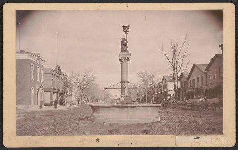


 1917
 1917
 1917


