4 places in town are on the National Register, among them a historic district. Below: 2 old photos and papers, maps from 1905 on, and the census since 1820.
Founding year: Wikidata. First post office: 1814.The full story ↓
History grade
What drives Groveland’s History grade
On its age, its old homes and the National Register, Groveland is more historic than 88% of U.S. towns. All 3 inputs are above most U.S. towns; its share of homes from before 1940 ranks highest and its National Register listings lowest.
A
HistoryA character grade: shown, never part of Groveland’s overall grade.
New York towns list more on the Register than most of the country (a typical New York town has 12.3 per 10,000 residents, the U.S. 2.4), so Groveland’s 15.8 sits near the middle of its state (52% of New York towns have fewer) while its 4 listings outnumber those of 68% of U.S. towns.
How sure. Graded on any two of the three inputs instead, the letter would range from B+ to A. The pre-1940 share is a Census survey estimate (±5.8 points). Two sources give 1792.
Founding year: Wikidata (other dates in Quick answers). Homes: Census ACS 2020–24. National Register: National Park Service, May 2026 list; each listing counted once (boundary changes and added documentation belong to their listing), and a historic district counts its contributing buildings. How TownRatings grades history →
What stands out about Groveland’s past
Read from the archive, the National Register and the record. The page puts what stands out first.
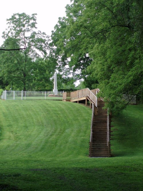
The Sullivan Expedition (1779) reached its farthest extent here. Groveland was the site of the Boyd and Parker ambush.
In 1792, the first planned European American settlement in Livingston County was located in Groveland and was called "Willamsburgh" after Sir William Pulteney, a land speculator. The town was formed in 1789 as part of Ontario County, later becoming part of Livingston County when it was formed in 1821. Part of Groveland was used to form part of the town of Conesus (1819).
Passages that mention Groveland, cut from the printed page as they were published.
History of Livingston County, New York, from its earliest traditions to the present1905 · page 1004Read the page →
Read the text
The town of Sparta originally extended from Livonia south to the Allegany county line, and west from Naples, Ontario county, to the Genesee river, embracing what are now the towns of Sparta, West Sparta, Groveland, North Dansville and a portion of Springwater. Groveland was formed in 1S12; a part of Springwater w-as cut off from Sparta in 1816; a part of Groveland was annexed in 1816. The other towns were formed many years later. vSparta is now bounded north by Conesus, east by Springwater, south by North Dansville, and west
Text read by machine from the scan; it may contain errors.
History of Livingston County, New York, from its earliest traditions to the present1905 · page 935Read the page →
Read the text
William Doty's in the southern part and Joseph Richardson's at Williamsburg. The following is a description of William Doty and his tavern : William Doty, Senior, came to what is now the town of Groveland, to reside permanently on June 4, 1806, from the township of Derry, County of Westmoreland, and State of Pennsylvania. This was his second visit. He had removed thither from the town of Groveland in the year 1795. On his first visit to the "Genesee Country," he resided
Text read by machine from the scan; it may contain errors.
A history of Livingston County, New York1876 · page 556Read the page →
Read the text
tlie town of Groveland. On its westerly side the township slopes down toward the Canaseraga creek, whoMe fiats comprise the remaining fourth part of the area. In June, 1812, the Legislature enacted "that from and after the first Monday of April next, all that part of the town of Sparta in the county of Ontario, comprehending township eight, in the seventh range, and the west half of tow^nship eight, in the sixth range
Text read by machine from the scan; it may contain errors.
A history of Livingston County, New York1876 · page 655Read the page →
Read the text
The town of Sparta was formed in January, 1789, and it originally embraced the towns of Sparta, West Sparta, Groveland and North Dansville, together with a portion of Springwater. Groveland was formed in 1812. A part of Springwater was taken from Sparta in 1816 ; and in 1846 Sparta was divided and the three towns formed first above named. A portion of Groveland was annexed in 1856. The surface of the town is
Text read by machine from the scan; it may contain errors.
Scans and text from the Internet Archive. Books published in 1930 or earlier, which are in the public domain.
Timeline
Groveland, 1792 to 1940
Woven from the archive, old maps, post office records, the National Register and the people born here.
In 1792, according to Wikidata. Groveland’s post office opened in 1814, and the census of 1820 counted 1,273 people here.
How does Groveland rank for history?
Groveland is more historic than 88% of U.S. towns. The History grade combines the town’s founding era, the share of homes built before 1940 and its National Register listings. It’s a character grade, so it isn’t part of the overall grade. How it works.
What is on the National Register in Groveland?
4 listings: 2 buildings, among them the Black and White Farm Barn (listed 1988, the first), 1 historic district, the Boyd & Parker Park and Groveland Ambuscade,, and 1 site.
How old are the homes in Groveland?
33% of Groveland’s homes were built before 1940 (Census estimate, ±5.8 points), against a typical 27% for a New York town; the median home was built in 1964.
Founding dates: Wikidata, Wikipedia, the U.S. post office records of Blevins & Helbock (CC0) and the Census. Homes by year built: Census ACS 2020–24. National Register of Historic Places: National Park Service (list of May 22, 2026). Old photos, postcards and papers: Wikimedia Commons, the Library of Congress and other public archives, credited on each item’s page. Maps: U.S. Geological Survey historical topographic maps (via Esri) and Sanborn fire-insurance maps (Library of Congress). History text and census tables: Wikipedia (CC BY-SA 4.0). Places that used to be: USGS Geographic Names Information System (2021).
From Wikimedia Commons (8), the National Register of Historic Places (4), Wikipedia, Wikidata and Wikipedia for famous people, U.S. Geological Survey historical maps, U.S. Census counts (via Wikipedia), the US Post Offices dataset (Blevins & Helbock), the USGS Geographic Names Information System and old county and town histories (Internet Archive). Archive images are copied here with their credits and licenses, shown on each photo’s page. Refreshed monthly.


 Date?
 Date?
 2018
 2018
 2014
 2006
 2006
 2006