The Cato post office opened in 1816, the earliest record of the town by name. Another post office, Cato Four Corners (1824), opened inside today’s town and later closed.
First census: 1,075 in 18102020 census: 2,445210 years
How historic is Cato?
A−
More historic than 84% of U.S. towns, on its age, its old homes and the National Register.
Founding year: the first Cato post office (Blevins & Helbock, CC0).The full story ↓
History grade
What drives Cato’s History grade
On its age, its old homes and the National Register, Cato is more historic than 84% of U.S. towns. All 3 inputs are above most U.S. towns; its share of homes from before 1940 ranks highest and its National Register listings lowest.
A−
HistoryA character grade: shown, never part of Cato’s overall grade.
New York towns list more on the Register than most of the country (a typical New York town has 12.3 per 10,000 residents, the U.S. 2.4), so Cato’s 7.9 sits near the middle of its state (42% of New York towns have fewer) while its 2 historic buildings outnumber those of 60% of U.S. towns.
How sure. Graded on any two of the three inputs instead, the letter would range from B+ to A. The pre-1940 share is a Census survey estimate (±5.1 points). The founding year is the first post office, not a stated founding date.
Founding year: the first post office (other dates in Quick answers). Homes: Census ACS 2020–24. National Register: National Park Service, May 2026 list; each listing counted once (boundary changes and added documentation belong to their listing), and a historic district counts its contributing buildings. How TownRatings grades history →
What stands out about Cato’s past
Read from the archive, the National Register and the record. The page puts what stands out first.
The town was in the Central New York Military Tract, reserved for veterans of the American Revolution. Settlers trickled in during the early 19th century. After the War of 1812, the population increased more quickly.
The town was formed in 1802 from part of the town of Aurelius. Cato was subsequently reduced in size when new towns were formed: Sterling in 1812, and in 1821 Conquest, Ira, and Victory. Part of the town of Ira was returned to Cato in 1824.
Passages that mention Cato, cut from the printed page as they were published.
History of Cayuga County, New York1879 · page 267Read the page →
Read the text
on the north by Sterling, on the east by Ira, on the south by Conquest, and on the west by Wayne Co. It is the north-west quarter of the old military town of Cato, from which it was formed March i6th, 1821. Its name, like that of Conquest, which town was organized at the same time, originates from the victory achieved by those who favored a division of the town of Cato
Text read by machine from the scan; it may contain errors.
Plutarch's lives of Romulus, Lycurgus, Solon, Pericles, Cato, Pompey, Alexander the Great, Julius Caesar, Demosthenes, Cicero, Mark Antony, Brutus, and others, and his comparisons. With notes, critical and historical1889 · page 176Read the page →
Read the text
Cato, who was never sparing in his own praises, and thought boasting a natural attendant on great actions, is very pompous in his account of this exploit He says, '* That those who saw him charging the enemy, routing and pursuing them, declared, that Cato owed less to the people of Rome, than the people of Rome owed to Cato ; and that the Consul Manius himself, coming hot from the fight, took him in his arms as he too came panting from
Text read by machine from the scan; it may contain errors.
History of Cayuga County, New York1879 · page 288Read the page →
Read the text
The river is spanned within the limits of the town by three bridges, two of wood and one of iron. The latter, in the south-east corner, connects Cato and Elbridge, and was built in 1868, at a cost of about $25,000, toward which Cayuga and Onondaga counties each contributed $5,000, the remainder being paid in equal shares by the towns of Cato and Elbridge. It replaced a wooden
Text read by machine from the scan; it may contain errors.
Scans and text from the Internet Archive. Books published in 1930 or earlier, which are in the public domain.
Timeline
Cato, 1816 to 1983
Woven from the archive, old maps, post office records, the National Register and the people born here.
Nothing in the archives for these yearsWeddings on Main Street, storms, parades, school pictures, the old store. If it’s in your family album, it belongs here.
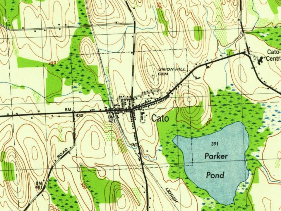
Fire insurance maps drew every building, what it was made of and what it was used for, so insurers could price the risk of fire. Pick a year, then a sheet.
The Cato post office opened in 1816, the earliest record of the town by name (U.S. post office records).
How does Cato rank for history?
Cato is more historic than 84% of U.S. towns. The History grade combines the town’s founding era, the share of homes built before 1940 and its National Register listings. It’s a character grade, so it isn’t part of the overall grade. How it works.
What is on the National Register in Cato?
One place: the William Smith Ingham House (listed 2005).
How old are the homes in Cato?
32% of Cato’s homes were built before 1940 (Census estimate, ±5.1 points), against a typical 27% for a New York town; the median home was built in 1974.
Founding dates: Wikidata, Wikipedia, the U.S. post office records of Blevins & Helbock (CC0) and the Census. Homes by year built: Census ACS 2020–24. National Register of Historic Places: National Park Service (list of May 22, 2026). Old photos, postcards and papers: Wikimedia Commons, the Library of Congress and other public archives, credited on each item’s page. Maps: U.S. Geological Survey historical topographic maps (via Esri) and Sanborn fire-insurance maps (Library of Congress). History text and census tables: Wikipedia (CC BY-SA 4.0). Places that used to be: USGS Geographic Names Information System (2021).
From Wikimedia Commons (10), the National Register of Historic Places (1), Wikipedia, Wikidata and Wikipedia for famous people, U.S. Geological Survey historical maps, U.S. Census counts (via Wikipedia), the US Post Offices dataset (Blevins & Helbock), the USGS Geographic Names Information System, Sanborn fire insurance maps (Library of Congress) and old county and town histories (Internet Archive). Archive images are copied here with their credits and licenses, shown on each photo’s page. Refreshed monthly.




 2024
 2024
 2024
 2019
 2018
 2018
 2017
 2012
 2008

