Rochester dates to 1749, and 18% of its homes were built before 1940
More historic than 92% of U.S. towns · #34 of 126 in New Hampshire. What drives it
2 places in town are on the National Register, among them a historic district with 86 buildings. Below: 6 old photos and papers, maps from 1887 on, and the census since 1790.
Founding year: Wikidata. First post office: 1812.The full story ↓
History grade
What drives Rochester’s History grade
On its age, its old homes and the National Register, Rochester is more historic than 92% of U.S. towns, #34 of 126 in New Hampshire. All 3 inputs are above most U.S. towns; its age ranks highest and its share of homes from before 1940 lowest.
A
HistoryA character grade: shown, never part of Rochester’s overall grade.
New Hampshire towns list more on the Register than most of the country (a typical New Hampshire town has 9.5 per 10,000 residents, the U.S. 2.4), so Rochester’s 26.2 sits above most of its state (68% of New Hampshire towns have fewer) while its 87 historic buildings outnumber those of 89% of U.S. towns.
NoteThe founding year comes from Wikidata alone; no second source gives 1749.
How sure. Graded on any two of the three inputs instead, the letter would range from A− to A+. The pre-1940 share (±2.2 points) is firm at this size.
Founding year: Wikidata (other dates in Quick answers). Homes: Census ACS 2020–24. National Register: National Park Service, May 2026 list; each listing counted once (boundary changes and added documentation belong to their listing), and a historic district counts its contributing buildings. How TownRatings grades history →
What stands out about Rochester’s past
Read from the archive, the National Register and the record. The page puts what stands out first.
The town was one of four granted by colonial governor Samuel Shute of Massachusetts and New Hampshire during his brief term. The other three were Barrington, Nottingham, and Chester. Incorporated in 1722, it was named for his close friend, Laurence Hyde, 1st Earl of Rochester, brother-in-law to King James II. As was customary, tall white pine trees were reserved for use as masts by the Royal Navy.
The same year the town was settled was the first year of Lovewell's War. There were no pitched battles in the town, but throughout the war, there were periodic ambushes of individual settlers. When the provincial assembly put a bounty on Indian scalps, the inhabitants of Rochester organized a militia led by Abraham Benwick to hunt down Indians.
Passages that mention Rochester, cut from the printed page as they were published.
History of the town of Rochester, New Hampshire, from 1722 to 18901892 · page 611Read the page →
Read the text
Sepf 5"' Moses Downs with Mercy Robinson both of Rochester Josiah Nute with Rebecca Nute both of Rochester Stephen Wille of Dover with Temperance Rollings of Rochester Sepf" 20"' John Lock of Barrington with Abigail Page of Rochester. Ocf 4"' John Roberts with Abigail Jones both of Rochester Ocf 14"' Robert Knight with Susanna Kimball both of Rochester Nov 18"' John Sherburne of Wakefield with Mary Twombly of Rochester Dec"" 3*1 John Downs it Sarah Door of Rochester married
Text read by machine from the scan; it may contain errors.
History of the town of Rochester, New Hampshire, from 1722 to 18901892 · page 609Read the page →
Read the text
March 23'' Josiah Hall of Conway with Susannah Place of Rochester March 27"* David Morrison with Mary Kimball both of Rochester April 2'' Clement Hayes with Joanna Wentworth both of Rochester April 5"* Moses Downs with Sarah Tripe both of Rochester April 6"* Closes Mighls of Parsonsfield with Elisalteth Page of Rochester April 8"* Andrew Hayes of Barrington with Sarah M'^Duffee Rochester.
Text read by machine from the scan; it may contain errors.
History of Strafford County, New Hampshire1914 · page 510Read the page →
Read the text
On Oct. 15, 1787, Rochester "voted to lay out a road from the Branch bridge to Palmer's mill." This was the first public road laid out in Milton, and was from some bridge in the present town of Rochester, and not from what is now known as the Branch bridge in Milton, for, at a meeting held the 31st day of the following March, they "voted to lay out a road from Palmer's mill to Wakefield line, if the owners will give the land." This road extended over Plumer's ridge, the Branch river, and what has since been known as the Branch hill, thus establishing a thoroughfare through the entire town from
Text read by machine from the scan; it may contain errors.
Scans and text from the Internet Archive. Books published in 1930 or earlier, which are in the public domain.
Timeline
Rochester, 1749 to 1963
Woven from the archive, old maps, post office records, the National Register and the people born here.
Nothing in the archives for these yearsWeddings on Main Street, storms, parades, school pictures, the old store. If it’s in your family album, it belongs here.
Fire insurance maps drew every building, what it was made of and what it was used for, so insurers could price the risk of fire. Pick a year, then a sheet.
In 1749, according to Wikidata. Rochester’s post office opened in 1812, and the first U.S. census counted 2,857 people here in 1790.
How does Rochester rank for history?
Rochester is more historic than 92% of U.S. towns, #34 of 126 in New Hampshire. The History grade combines the town’s founding era, the share of homes built before 1940 and its National Register listings. It’s a character grade, so it isn’t part of the overall grade. How it works.
What is on the National Register in Rochester?
Two places: the Rochester Commercial and Industrial District (listed 1983) and the Richard Hayes House (1986).
How old are the homes in Rochester?
18% of Rochester’s homes were built before 1940 (Census estimate, ±2.2 points), against a typical 17% for a New Hampshire town; the median home was built in 1978.
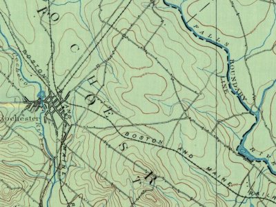
Founding dates: Wikidata, Wikipedia, the U.S. post office records of Blevins & Helbock (CC0) and the Census. Homes by year built: Census ACS 2020–24. National Register of Historic Places: National Park Service (list of May 22, 2026). Old photos, postcards and papers: Wikimedia Commons, the Library of Congress and other public archives, credited on each item’s page. Maps: U.S. Geological Survey historical topographic maps (via Esri) and Sanborn fire-insurance maps (Library of Congress). History text and census tables: Wikipedia (CC BY-SA 4.0). Places that used to be: USGS Geographic Names Information System (2021).
From Wikimedia Commons (5), the Library of Congress (1), the National Register of Historic Places (2), Wikipedia, U.S. Geological Survey historical maps, U.S. Census counts (via Wikipedia), the US Post Offices dataset (Blevins & Helbock), the USGS Geographic Names Information System, Sanborn fire insurance maps (Library of Congress) and old county and town histories (Internet Archive). Archive images are copied here with their credits and licenses, shown on each photo’s page. Refreshed monthly.



 1877
 1884
 1885
