Claremont dates to 1762, and 36% of its homes were built before 1940
More historic than 98% of U.S. towns · #7 of 126 in New Hampshire. What drives it
8 places in town are on the National Register, among them three historic districts with 70 buildings between them. Below: 12 old photos and papers, maps from 1884 on, and the census since 1790.
Founding year: Wikidata. First post office: 1802.The full story ↓
History grade
What drives Claremont’s History grade
On its age, its old homes and the National Register, Claremont is more historic than 98% of U.S. towns, #7 of 126 in New Hampshire. All 3 inputs are above most U.S. towns; its age ranks highest and its National Register listings lowest.
A+
HistoryA character grade: shown, never part of Claremont’s overall grade.
New Hampshire towns list more on the Register than most of the country (a typical New Hampshire town has 9.5 per 10,000 residents, the U.S. 2.4), so Claremont’s 57.3 sits above most of its state (77% of New Hampshire towns have fewer) while its 75 historic buildings outnumber those of 88% of U.S. towns.
NoteThe founding year comes from Wikidata alone; no second source gives 1762.
How sure. Graded on any two of the three inputs instead, the letter would range from A to A+. The pre-1940 share is a Census survey estimate (±5.4 points).
Founding year: Wikidata (other dates in Quick answers). Homes: Census ACS 2020–24. National Register: National Park Service, May 2026 list; each listing counted once (boundary changes and added documentation belong to their listing), and a historic district counts its contributing buildings. How TownRatings grades history →
What stands out about Claremont’s past
Read from the archive, the National Register and the record. The page puts what stands out first.
Fire insurance maps drew every building, what it was made of and what it was used for, so insurers could price the risk of fire. Pick a year, then a sheet.
The Upper Connecticut River Valley was home to the Pennacook and Western Abenaki (Sokoki) peoples, later merging with members of other Algonquin tribes displaced by the wars and famines which accompanied the European settling of the region. The Hunter Archeological Site, located near the bridge connecting Claremont with Ascutney, Vermont, is a significant prehistoric Native American site that includes seven levels of occupational evidence, including evidence of at least three longhouses. The oldest dates recorded from evidence gathered during excavations in 1967 were to 1300 CE.
Passages that mention Claremont, cut from the printed page as they were published.
History of the town of Claremont, New Hampshire, for a period of one hundred and thirty years from 1764 to 18941895Read the page →
Read the text
The above deed was read at a town meeting, held Agust 15, 1873, when the following resolution was passed : Resolved by the town of Claremont, That we cordially accept the munificent gift of Two Thousand volumes of valuable books from Samuel P. Fiske, Esq., upon the conditions and terms of his deed of trust to said town of Claremont, dated August 7, 1873, hereby pledging to the donor that such conditions shall be faithfully complied with, on the part of the town, for the use and perpetuation of the Fiske Free Library.
Text read by machine from the scan; it may contain errors.
History of the town of Claremont, New Hampshire, for a period of one hundred and thirty years from 1764 to 18941895Read the page →
Read the text
The town of Claremont, as originally granted, was six miles square, and contained twentj-'four thousand acres. In 1828, by act of the legislature, a tract of land nearly a mile long, and a little more than a half mile wide, embracing what have been known as the Francis Whitcomb, Jacob Smith, Winthrop Sargent, Ira Colby, and Joshua Colby farms, was set off from the town of Unity on to Claremont. The town is bounded on the north by Cornish, east by Newport, south by Unity and Charlestown,
Text read by machine from the scan; it may contain errors.
Scans and text from the Internet Archive. Books published in 1930 or earlier, which are in the public domain.
Timeline
Claremont, 1762 to 1993
Woven from the archive, old maps, post office records, the National Register and the people born here.
Nothing in the archives for these yearsWeddings on Main Street, storms, parades, school pictures, the old store. If it’s in your family album, it belongs here.
In 1762, according to Wikidata. Claremont’s post office opened in 1802, and the first U.S. census counted 1,435 people here in 1790.
How does Claremont rank for history?
Claremont is more historic than 98% of U.S. towns, #7 of 126 in New Hampshire. The History grade combines the town’s founding era, the share of homes built before 1940 and its National Register listings. It’s a character grade, so it isn’t part of the overall grade. How it works.
What is on the National Register in Claremont?
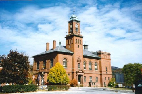
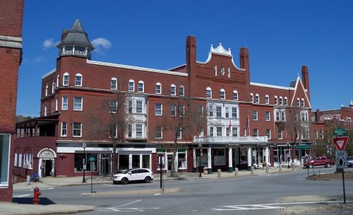
8 listings: 5 buildings, among them the Claremont City Hall (listed 1973, the first), and 3 historic districts, the Central Business District, the Lower Village District and the Monadnock Mills, with 70 contributing buildings. 75 historic buildings in all.
How old are the homes in Claremont?
36% of Claremont’s homes were built before 1940 (Census estimate, ±5.4 points), against a typical 17% for a New Hampshire town; the median home was built in 1957.
Founding dates: Wikidata, Wikipedia, the U.S. post office records of Blevins & Helbock (CC0) and the Census. Homes by year built: Census ACS 2020–24. National Register of Historic Places: National Park Service (list of May 22, 2026). Old photos, postcards and papers: Wikimedia Commons, the Library of Congress and other public archives, credited on each item’s page. Maps: U.S. Geological Survey historical topographic maps (via Esri) and Sanborn fire-insurance maps (Library of Congress). History text and census tables: Wikipedia (CC BY-SA 4.0). Places that used to be: USGS Geographic Names Information System (2021).
From Wikimedia Commons (12), the National Register of Historic Places (8), Wikipedia, Wikidata and Wikipedia for famous people, U.S. Geological Survey historical maps, U.S. Census counts (via Wikipedia), the US Post Offices dataset (Blevins & Helbock), the USGS Geographic Names Information System, Sanborn fire insurance maps (Library of Congress) and old county and town histories (Internet Archive). Archive images are copied here with their credits and licenses, shown on each photo’s page. Refreshed monthly.




 1874
 1877
 c. 1905
 1905
 c. 1906
 1907
 1908
 1909


